
Sonoma County is a county in the U.S. state of California. As of the 2010 United States Census, its population was 483,878. Its county seat and largest city is Santa Rosa. It is to the north of Marin County and the south of Mendocino County. It is west of Napa County and Lake County.

The Sepulveda Dam is a project of the U.S. Army Corps of Engineers designed to withhold winter flood waters along the Los Angeles River. Completed in 1941, at a cost of $6,650,561, it is located south of center in the San Fernando Valley, approximately eight miles east of the river's source in the western end of the Valley, in Los Angeles, California.

Lake Oroville is a reservoir formed by the Oroville Dam impounding the Feather River, located in Butte County, northern California. The lake is situated 5 miles (8.0 km) northeast of the city of Oroville, within the Lake Oroville State Recreation Area, in the western foothills of the Sierra Nevada. Known as the second-largest reservoir in California, Lake Oroville is treated as a keystone facility within the California State Water Project by storing water, providing flood control, recreation, freshwater releases assist in controlling the salinity intrusion Sacramento-San Joaquin Delta and protecting fish and wildlife.

The Santa Ynez River is one of the largest rivers on the Central Coast of California. It is 92 miles (148 km) long, flowing from east to west through the Santa Ynez Valley, reaching the Pacific Ocean at Surf, near Vandenberg Air Force Base and the city of Lompoc.
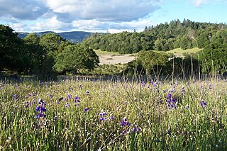
Trione-Annadel State Park is a state park of California in the United States. It is situated at the northern edge of Sonoma Valley and is adjacent to Spring Lake Regional Park in Santa Rosa. It offers many recreational activities within its 5,092-acre (2,061 ha) property.

Sonoma Creek is a 33.4-mile-long (53.8 km) stream in northern California. It is one of two principal drainages of southern Sonoma County, California, with headwaters rising in the rugged hills of Sugarloaf Ridge State Park and discharging to San Pablo Bay, the northern arm of San Francisco Bay. The watershed drained by Sonoma Creek is roughly equivalent to the wine region of Sonoma Valley, an area of about 170 square miles (440 km2). The State of California has designated the Sonoma Creek watershed as a “Critical Coastal Water Resource”. To the east of this generally rectangular watershed is the Napa River watershed, and to the west are the Petaluma River and Tolay Creek watersheds.

Limnanthes vinculans, the Sebastopol meadowfoam, is an endangered species of meadowfoam found only in the Laguna de Santa Rosa in Sonoma County, California, United States and an area slightly to the south in the Americano Creek and Washoe Creek watersheds. The name vinculans derives from the Latin root vinculum, meaning "a bond, a cord." The specific epithet vinculans means linking or bonding, in reference to the sharing of some characters of L. vinculans with L. douglasii (R.Br) and L. bakeri.

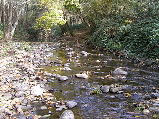
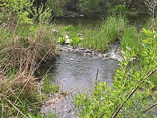
Matanzas Creek is an 11.4-mile-long (18.3 km) year-round stream in Sonoma County, California, United States, a tributary of Santa Rosa Creek.
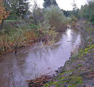
Santa Rosa Creek is a 22-mile-long (35 km) stream in Sonoma County, California, which rises on Hood Mountain and discharges to the Laguna de Santa Rosa by way of the Santa Rosa Flood Control Channel. This article covers both the creek and the channel.
Brush Creek or Rincon Creek is a tributary of Santa Rosa Creek in Sonoma County, California. Brush Creek rises in the southern slopes of the Mayacamas Mountains within Sonoma County. The lower reach of the creek is a suburban medium density residential area in the city of Santa Rosa, and that reach of Brush Creek has been restored during the 1990s under a U.S. Environmental Protection Agency grant to promote steelhead migration and spawning. Further restoration and incorporation into citywide park planning is currently underway as of 2006. The location of the confluence with Santa Rosa Creek is particularly noteworthy, since it was a locus of prehistoric life as a village of the Pomo people and a scenic geologic feature of massive flat boulder outcrops within the stream channel.

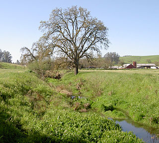
Copeland Creek is a 9.0-mile-long (14.5 km) perennial stream that rises on Sonoma Mountain in Sonoma County, California.

The Laguna de Santa Rosa is a 22-mile-long (35 km) wetland complex that drains a 254-square-mile (660 km2) watershed encompassing most of the Santa Rosa Plain in Sonoma County, California, United States.
Washoe Creek is a perennial stream located in Sonoma County, California. It is about 2 mi (3 km) long and discharges to the Laguna de Santa Rosa.
Piner Creek is a stream in northeast Santa Rosa, California, United States which originates as an outlet of Fountaingrove Lake. Piner Creek discharges to Santa Rosa Creek which in turn joins the Laguna de Santa Rosa. The upper reaches in the foothills of the Mayacamas Mountains are at elevations of 200 to 300 feet, while the lower and middle reaches are located on the Santa Rosa Plain at elevations of between the 110- and 140-foot contours; therefore, these lower reaches have a gradient of about 1:250 toward the southwest. Geologic studies in the lower and middle reaches of Piner Creek indicate groundwater levels ranging from three to 15 feet below the surface. Prior to extensive urban development of the middle and lower reaches, the landscape earlier bore extensive agricultural uses including plum orchards, which fruit was subsequently processed for prunes.
Tolay Lake is a shallow freshwater lake in southern Sonoma County, California, United States. The lake, nestled within the southern vestiges of the Sonoma Mountains, is the site of significant Native American prehistoric seasonal settlement. In 2005, Sonoma County acquired the entirety of the lake and virtually its whole drainage basin from the Cardoza family for the sum of $18 million; the County's intention is to utilize the property as Tolay Lake Regional Park for ecological and archaeological preservation, as well as public use and enjoyment. Tolay Lake and its immediate drainage area is home to several nesting pairs of golden eagles, Aquila chrysaetos, and a number of rare, threatened or endangered species including the California red-legged frog, Rana draytonii; Western pond turtle, Actinemys marmorata; and Western burrowing owl, Athene cunicularia.

Lilium pardalinum subsp. pitkinense, the Pitkin Marsh lily, is an endangered perennial herb of the family Liliaceae that is endemic to certain wetland areas in the northern California Coast Ranges of Sonoma County, California, United States. It is a subspecies of Lilium pardalinum.

The Los Vaqueros Reservoir is located in the northern Diablo Range, within northeastern Contra Costa County, northern California. It was completed by the Contra Costa Water District (CCWD) in 1998 to improve the quality of drinking water for its 550,000 customers in Central and Eastern Contra Costa County, and the reservoir is accessible via Vasco Road, a road which connects Brentwood and Livermore.

Fountain Grove was a utopian colony founded near Santa Rosa, California, by Thomas Lake Harris in 1875. Most of its settlers were followers of Harris's Brotherhood of the New Life and moved with Harris from their previous colony at Brocton, New York.
Sonoma Water, formerly known as the Sonoma County Water Agency, maintains a water transmission system that provides naturally filtered Russian River water to more than 600,000 residents in portions of Sonoma County, California and Marin County, California. The Water Agency is a water wholesaler that sells potable water to nine cities and special districts that in turn sell drinking water to their residents. These cities and special districts are: the City of Santa Rosa, Rohnert Park, Cotati, Petaluma, Sonoma, the Town of Windsor, Valley of the Moon Water District, Marin Municipal Water District, and North Marin Water District.

The Tubbs Fire was a wildfire in Northern California during October 2017. At the time, the Tubbs Fire was the most destructive wildfire in California history, burning parts of Napa, Sonoma, and Lake counties, inflicting its greatest losses in the city of Santa Rosa. Its destructiveness was surpassed only a year later by the Camp Fire of 2018. The Tubbs Fire was one of more than a dozen large fires that broke out in early October 2017, which were simultaneously burning in eight Northern California counties, in what was called the "Northern California firestorm." By the time of its containment on October 31, the fire was estimated to have burned 36,810 acres (149 km2); at least 22 people were believed to have been killed in Sonoma County by the fire.


