
Sonoma County is a county located in the U.S. state of California. As of the 2020 United States Census, its population was 488,863. Its seat of government and largest city is Santa Rosa.

Santa Rosa is a city in and the county seat of Sonoma County, in the North Bay region of the Bay Area in California. Its population as of the 2020 census was 178,127. It is the largest city in California's Wine Country and Redwood Coast. It is the fifth most populous city in the Bay Area after San Jose, San Francisco, Oakland, and Fremont; and the 25th-most populous city in California.

Wine Country is a region of California, in the northern San Francisco Bay Area, known worldwide as a premier wine-growing region. The region is famed for its wineries, its cuisine, Michelin star restaurants, boutique hotels, luxury resorts, historic architecture, and culture. Viticulture and wine-making have been practiced in the region since the Spanish missionaries from Mission San Francisco Solano established the first vineyards in 1812.
Trione-Annadel State Park is a state park of California in the United States. It is situated at the northern edge of Sonoma Valley and is adjacent to Spring Lake Regional Park in Santa Rosa. It offers many recreational activities within its 5,092-acre (2,061 ha) property.

Mount Hood, also known as Hood Mountain, is a mountain near the southeastern edge of Santa Rosa, California, at the northeast of the Sonoma Valley and attains a height of 2,733 feet (833 m). The original name was Mount Wilikos, an Indian name meaning "willows." Most of the drainage from Mount Hood contributes to the headwaters of Sonoma Creek. A prominent feature is the extensive rock face visible on the upper half of the mountain as viewed from State Route 12. The habitats on the mountain include mixed oak forest, pygmy forest, chaparral and riparian zones. In prehistoric times the slopes of Mount Hood were inhabited by a division of the Yuki tribe. Most of Mount Hood is within the Hood Mountain Regional Park maintained by Sonoma County. Mount Hood is part of the inner coast Mayacamas Range, and lies mostly within Sonoma County, with a part of the mountain geographically within Napa County. Mount Hood affords overlooks of the Pacific Ocean, San Francisco Bay and "a spectacular view east to the Sierra Nevada Range."

Sonoma Mountain is a prominent landform within the Sonoma Mountains of southern Sonoma County, California. At an elevation of 2,463 ft (751 m), Sonoma Mountain offers expansive views of the Pacific Ocean to the west and the Sonoma Valley to the east. In fact, the viticultural area extends in isolated patches up the eastern slopes of Sonoma Mountain to almost 1,700 feet (520 m) in elevation.

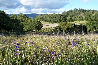
The Fairfield Osborn Preserve is a 450-acre nature reserve situated on the northwest flank of Sonoma Mountain in Sonoma County, California. There are eight plant communities within the property, oak woodland being the dominant type. Other communities include chaparral, Douglas fir woodland, native Bunch grass, freshwater marsh, vernal pool, pond and riparian woodland. The flora is extremely diverse including many native trees, shrubs, wildflowers, grasses, lichens and mosses. A diverse fauna inhabits this area including black-tailed deer, coyote, bobcat and an occasional mountain lion; moreover, there are abundant avifauna, amphibians, reptiles and insects.
Copeland Creek is a 9.0-mile-long (14.5 km) perennial stream that rises on Sonoma Mountain in Sonoma County, California.
The Sonoma Mountains are a northwest–southeast trending mountain range of the Inner Coast Ranges in the California Coast Ranges System, located in Sonoma County, Northern California.

Bennett Valley is a northwest- to southeast-trending valley in Sonoma County, California, US, approximately 1 mile (1.6 km) wide in its northwestern portion, where the southeast extremity of Santa Rosa, California is located. The axis of the valley floor slopes 40 feet (12 m) per mile from the pinched central portion of the valley, where knolls divide the northwestern from the southeastern segment of the valley. Bennett Valley is drained by Matanzas Creek which is incised into the valley floor; an unnamed stream and Spring Creek drain into Matanzas Creek from the east side of Bennett Valley below the Matanzas Creek Reservoir. A flood-control reservoir on Matanzas Creek in the central portion of the valley collects water from the drainage of the upper portion of the valley. Precipitation in the valley varies from approximately 35 to 40 inches per year. The latter amount falls on Taylor Mountain, located immediately above Bennett Valley, in an outlier spur of the Sonoma Mountains sometimes called the Los Gullicos Range. Rainfall occurs primarily during winters, separated by warm dry summers. Bennett Valley is accessed chiefly via Bennett Valley Road, which traverses the valley floor to connect southeast Santa Rosa with Warm Springs Road in Glen Ellen.

Rancho San Antonio County Park and Rancho San Antonio Open Space Preserve are a conjoined public recreational area in the Santa Cruz Mountains, in the northwest quadrant of Santa Clara County, California. The County Park is bordered by Los Altos with some parts of the eastern part of the County Park in western Cupertino. The Open Space Preserve is on the west side of the County Park, also bordered by Los Altos Hills, Monte Bello Open Space Preserve, and the Permanente Quarry.

Crane Creek is a stream in Sonoma County, California, United States which rises in the northern Sonoma Mountains. This watercourse flows through Crane Canyon and the Crane Creek Regional Park situated on the northwestern flank of Sonoma Mountain. Crane Creek forms a confluence with Hinebaugh Creek in the city of Rohnert Park; thereafter, the channelized Hinebaugh Creek flows westerly to discharge to the Laguna de Santa Rosa. Hiking access to the upper Crane Creek reaches is from Roberts Road off Petaluma Hill Road.
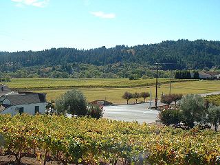
Sonoma County wine is wine made in Sonoma County, California, in the United States.
The Bennett Valley AVA is an American Viticultural Area located in Sonoma County, California. The boundaries of this appellation lie completely within the North Coast AVA, almost completely within the Sonoma Valley AVA and overlaps into some areas of the Sonoma Coast AVA and Sonoma Mountain AVA. The region was granted AVA status on December 23, 2003 following the petition of Matanzas Creek Winery. The AVA is surrounded to the south, east and west by the Sonoma Mountains and to the north by the city of Santa Rosa, California. The region receives a moderating effect on its climate from Pacific Ocean through the cool coastal fogs and breeze that creep into the area from the southwest through Crane Canyon between Sonoma Mountain and Taylor Mountain. Barbera, Cabernet Sauvignon, Cabernet Franc, Chardonnay, Grenache, Merlot, Pinot noir, Sauvignon blanc and Syrah are the leading grape varieties planted.

The Spring Mountain District AVA is an American Viticultural Area located in the Napa Valley AVA in California. Spring Mountain District AVA was officially established as an American Viticulture Area in 1993. Encompassed within its bounds are about 8,600 acres (3,480 ha), of which about 1,000 acres (400 ha) are planted to vineyards. Given the small crop yields on hillsides, the region represents less than 2% of Napa Valley wine. Currently the region has just over 30 winegrowers.

Bennett Mountain, also commonly known as Bennett Peak, is a 1,909-foot (582 m) summit in the Sonoma Mountains of California. Located on the west edge of Annadel State Park, it separates Bennett Valley in the Russian River drainage basin from Sonoma Valley in the Sonoma Creek drainage basin.

Monte Bello Open Space Preserve is a 3,133-acre (12.68 km2) open space preserve, located near Palo Alto in the Santa Cruz Mountains, in San Mateo and Santa Clara Counties, California, United States. The preserve encompasses the upper Stevens Creek watershed in the valley between Monte Bello Ridge and Skyline Ridge. "Monte Bello" means "beautiful mountain" in Italian, and refers to Black Mountain which is the highest part of Montebello Ridge. The straight valley of upper Stevens Creek is also the rift valley of the San Andreas Fault.

El Sereno Open Space Preserve is a park unit of the Midpeninsula Regional Open Space District located on the peak and slopes of 2580 ft. El Sereno mountain, a peak in the Santa Cruz Mountains. The preserve is located in Santa Clara County, California.

Petaluma Gap is an American Viticultural Area (AVA) established on January 8, 2018 by the Alcohol and Tobacco Tax and Trade Bureau (TTB), Treasury. The area spans 202,476 acres (316 sq mi) stretching through an 30 miles (48 km) inland valley from the Pacific coast at Bodega Bay southeast to Highway 37 at Sears Point on San Pablo Bay straddling the border of northern Marin and southern Sonoma counties. The AVA lies entirely within the North Coast AVA and partially in the Sonoma Coast AVA with eighty commercially-producing vineyards cultivating 4,000 acres (1,619 ha) and nine bonded wineries. The wind gap in its coastal mountain range funnels cooling breezes and fog east from the Pacific Ocean through the city of Petaluma to San Pablo Bay. A persistent afternoon breeze causes lower grape yields and longer hang time contributes to the AVA vintages' unique flavors and fruit characteristics which defines their character and distinction.


