
The Sierra Nevada is a mountain range in the Western United States, between the Central Valley of California and the Great Basin. The vast majority of the range lies in the state of California, although the Carson Range spur lies primarily in Nevada. The Sierra Nevada is part of the American Cordillera, an almost continuous chain of mountain ranges that forms the western "backbone" of the Americas.

Nevada County is a county located in the U.S. state of California, in the Sierra Nevada. As of the 2020 census, its population was 102,241. The county seat is Nevada City. Nevada County comprises the Truckee-Grass Valley micropolitan statistical area, which is also included in the Sacramento-Roseville combined statistical area, part of the Mother Lode Country.

Plumas County is a county in the Sierra Nevada of the U.S. state of California. As of the 2020 census, the population was 19,790. The county seat is Quincy, and the only incorporated city is Portola. The largest community in the county is East Quincy. The county was named for the Spanish Río de las Plumas, which flows through it. The county itself is also the namesake of a native moth species, Hadena plumasata.

Sierra County is a county located in the U.S. state of California. As of the 2020 census, the population was 3,236, making it California's second-least populous county. The county seat is Downieville; the sole incorporated city is Loyalton. The county is in the Sierra Nevada, northeast of Sacramento on the border with Nevada.

Graeagle is a town and census-designated place in eastern Plumas County, California, United States, located along the Middle Fork Feather River in the Northern Sierra Nevada. The population was 737 as of 2010.

La Porte is a census-designated place (CDP) in Plumas County, California, United States. The population was 65 at the 2020 census. The town was first known as Rabbit Creek until 1857.

State Route 49 is a north–south state highway in the U.S. state of California that passes through many historic mining communities of the 1849 California gold rush and it is known as the Golden Chain Highway. The highway's creation was lobbied by the Mother Lode Highway Association, a group of locals and historians seeking a single highway to connect many relevant locations along the Gold Rush to honor the 49ers. One of the bridges along SR 49 is named for the leader of the association, Archie Stevenot.

Tahoe National Forest is a United States National Forest located in California, northwest of Lake Tahoe. It includes the 8,587-foot (2,617 m) peak of Sierra Buttes, near Sierra City, which has views of Mount Lassen and Mount Shasta. It is located in parts of six counties: Sierra, Placer, Nevada, Yuba, Plumas and El Dorado. The forest has a total area of 871,495 acres. Its headquarters is in Nevada City, California. There are local ranger district offices in Camptonville, Foresthill, Sierraville and Truckee.

State Route 89 is a state highway in the U.S. state of California that travels in the north–south direction, serving as a major thoroughfare for many mountain communities in the Sierra Nevada and the Cascade Range. It starts from U.S. Route 395 near Topaz Lake, winding its way up to the 8,314-foot (2,534 m) Monitor Pass, down to the Carson River, and up again over the 7,740-foot (2,359 m) Luther Pass. From that point on, the route generally loses elevation on its way past Lake Tahoe, through Tahoe and Plumas National Forests until Lake Almanor. For roughly nine miles the route is then a part of State Route 36. The route then ascends to the 5,753-foot (1,754 m) Morgan Summit. After it enters Lassen Volcanic National Park it continues to gain elevation until it reaches its highest point in an unnamed pass in the middle of Lassen Peak and Bumpass Mountain. The road then descends and heads northwest, finally terminating at Interstate 5 at the foot of Mount Shasta at around 3,600 feet (1,100 m).

Empire Mine State Historic Park is a state-protected mine and park in the Sierra Nevada mountains in Grass Valley, California, U.S. The Empire Mine is on the National Register of Historic Places, a federal Historic District, and a California Historical Landmark. Since 1975 California State Parks has administered and maintained the mine as a historic site. The Empire Mine is "one of the oldest, largest, deepest, longest and richest gold mines in California". Between 1850 and its closure in 1956, the Empire Mine produced 5.8 million ounces of gold, extracted from 367 miles (591 km) of underground passages.

The Palisades Tahoe Aerial Tram is a 1.5-mile (2.4 km) long aerial tramway at the Palisades Tahoe ski resort in Olympic Valley, California. It was inaugurated in 1968, and was called the Cable Car. At its opening, it was the largest tramway in the world, built by an Austrian company Garaventa. It carries passengers from the Base Camp at 6,200 feet (1,889m) elevation to High Camp at 8,200 feet (2,499m) elevation. The tram operated operates year-round.

Area code 530 is a telephone area code in the North American Numbering Plan (NANP) in northeastern and Northern California. It was created in 1997 in an area code split of 916.
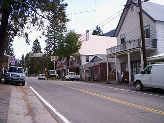
Sierra City is a census-designated place in Sierra County, California, United States. The elevation of Sierra City is 4,147 feet (1,264 m), and the town is situated in the canyon of the North Yuba River on California State Route 49, twelve miles northeast of the county seat of Sierra County, Downieville. The population was 221 at the 2010 census.

The Wasatch and Uinta montane forest is a temperate coniferous forest ecoregion in the Wasatch Range and Uinta Mountains of the western Rocky Mountains system, in the Western United States.
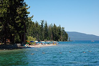
Ed Z'berg Sugar Pine Point State Park is a state park in California in the United States. It occupies nearly two miles of the western shore of Lake Tahoe and a total of about 1,000 hectares of forested mountains in El Dorado County. Originally called Sugar Pine Point State Park, its name was changed in 2003 to honor Edwin L. Z'berg, a California state assemblyman who specialized in environmental legislation and worked to develop state parks and other natural areas.
Onion Valley, California is a former California gold rush mining settlement and supply station in Plumas County, California, United States.
The protected areas of the Sierra Nevada, a major mountain range located in the U.S. states of California and Nevada, are numerous and highly diverse. Like the mountain range itself, these areas span hundreds of miles along the length of the range, and over 14,000 feet of elevation from the lowest foothills to the summit of Mount Whitney.
The Lost Sierra is the northern Sierra Nevada region in California in the United States. It encompasses the area of Plumas and Sierra Counties.
Eureka Peak is a 7,447-foot granite peak in the Northern Sierra Nevada in Plumas County, California in the United States.


