Mount Whitney is the highest mountain in the contiguous United States, with an elevation of 14,505 feet (4,421 m). It is in East–Central California, in the Sierra Nevada, on the boundary between California's Inyo and Tulare counties, and 84.6 miles (136.2 km) west-northwest of North America's lowest topographic point, Badwater Basin in Death Valley National Park, at 282 ft (86 m) below sea level. The mountain's west slope is in Sequoia National Park and the summit is the southern terminus of the John Muir Trail, which runs 211.9 mi (341.0 km) from Happy Isles in Yosemite Valley. The eastern slopes are in Inyo National Forest in Inyo County. Mount Whitney is ranked 18th by topographic isolation.
Mount Dana is a mountain in the U.S. state of California. Its summit marks the eastern boundary of Yosemite National Park and the western boundary of the Ansel Adams Wilderness. At an elevation of 13,061 feet (3,981 m), it is the second highest mountain in Yosemite, and the northernmost summit in the Sierra Nevada which is over 13,000 feet (3,962.4 m) in elevation. Mount Dana is the highest peak in Yosemite that accessible to summit. The mountain is named in honor of James Dwight Dana, who was a professor of natural history and geology at Yale.

Grays Peak is the tenth-highest summit of the Rocky Mountains of North America and the U.S. state of Colorado. The prominent 14,276-foot (4351.18 m) fourteener is the highest summit of the Front Range and the highest point on the Continental Divide and the Continental Divide Trail in North America. Grays Peak is located in Arapahoe National Forest, 3.9 miles (6.2 km) southeast by east of Loveland Pass on the Continental Divide between Clear Creek and Summit counties. The peak is the highest point in both counties.

Wheeler Peak is the highest natural point in the U.S. state of New Mexico. It is located northeast of Taos and south of Red River in the northern part of the state, and just 2 miles (3.2 km) southeast of the ski slopes of Taos Ski Valley. It lies in the Sangre de Cristo Mountains, the southernmost subrange of the Rocky Mountains. The peak's elevation is 13,167 feet (4,013 m).

Humphreys Peak is the highest mountain and the second most prominent peak after Mount Graham in the U.S. state of Arizona. With an elevation of 12,633 feet (3,851 m), it is located within the Kachina Peaks Wilderness in the Coconino National Forest, about 11 miles (17.7 km) north of Flagstaff, Arizona. Humphreys Peak is the highest of a group of dormant volcanic peaks known as the San Francisco Peaks.

Mount Harvard is the third highest summit of the Rocky Mountains of North America and the U.S. state of Colorado. The prominent 14,421-foot (4395.6 m) fourteener is the highest summit of the Collegiate Peaks and the fourth highest summit in the contiguous United States. Mount Harvard is located in the Collegiate Peaks Wilderness of San Isabel National Forest, 11.7 miles (18.9 km) northwest by west of the Town of Buena Vista in Chaffee County, Colorado, United States. The summit of Mount Harvard is the highest point in Chaffee County and is higher than any point in the United States east of its longitude. The mountain was named in honor of Harvard University.

Algonquin Peak is a mountain in the MacIntyre Range of the Adirondacks in the U.S. state of New York. It is the second-highest mountain in New York, with an elevation of 5,114 feet (1,559 m), and one of the 46 Adirondack High Peaks. It is located in the town of North Elba in Essex County and in the High Peaks Wilderness Area of Adirondack Park. The first recorded ascent of the mountain was made on August 8, 1837, by a party led by New York state geologist Ebenezer Emmons. It was originally named Mount McIntyre, after Archibald McIntyre, but this name was eventually applied to the entire range. Surveyor Verplanck Colvin added the name "Algonquin" in 1880. This name came from the peak reputedly being on the Algonquian side of a nearby informal boundary between the Algonquian and their Iroquois neighbors, although no such boundary existed in reality.
Dix Mountain is a mountain in the Dix Range of the Adirondacks in the U.S. state of New York. With an elevation of 4,857 feet (1,480 m), it is the sixth-highest peak in New York and one of the 46 Adirondack High Peaks. It is located roughly on the boundary between the towns of North Hudson and Keene in Essex County, and in the High Peaks Wilderness Area of Adirondack Park. The crest of the peak consists of a very narrow ridge, which continues to the southeast and rises to a subsidiary peak named Beckhorn, then continues south to other peaks of the Dix Range. The summit is also in an alpine zone above the treeline. The ridge offers unobstructed views of Elk Lake to the southwest, the Great Range to the northwest, and Lake Champlain and the Green Mountains to the east.

Quandary Peak is the highest summit of the Tenmile Range in the Rocky Mountains of North America and is the most commonly climbed fourteener in Colorado. It has nearly the same elevation as Castle Peak and Mount Blue Sky. It lies in Summit County and within the White River National Forest about 6 miles (10 km) south-southwest of the town of Breckenridge.

Mount Williamson, at an elevation of 14,379 feet (4,383 m), is the second-highest mountain in both the Sierra Nevada range and the state of California, and the sixth-highest peak in the contiguous United States.

Mount Langley is a mountain located on the crest of the Sierra Nevada, on the boundary between Inyo and Tulare counties in eastern California, in the United States. To the east is the Owens Valley, and to the west is the Kern River Valley. It is the ninth-highest peak in the state and the seventh-highest in the Sierra. Mount Whitney, the highest peak in the contiguous United States, lies 4.8 miles (7.7 km) to the northwest. Mount Langley also has the distinction of being the southernmost fourteener in the United States.

Giant Mountain, also known as Giant of the Valley, is a mountain in the Adirondacks in the U.S. state of New York. It is the twelfth-highest peak in New York, with an elevation of 4,627 feet (1,410 m), and one of the 46 High Peaks in Adirondack Park. It is located in the Giant Mountain Wilderness Area, in the town of Keene in Essex County. The mountain is named for its towering appearance from the nearby Pleasant Valley to the east, which sits at a low elevation.

Bald Mountain is a 11,949-foot (3,642 m) peak in the western Uinta Mountain Range in the Uinta-Wasatch-Cache National Forest on the border between Summit and Wasatch counties in northeastern Utah, United States.

Esther Mountain is a mountain in the Adirondacks in the U.S. state of New York. It is the 28th-highest of the Adirondack High Peaks, with an elevation of 4,240 feet (1,290 m). The mountain is located in the town of Wilmington in Essex County, and is the northernmost of the High Peaks. It was the only High Peak named for a woman until 2014, having been named in honor of Esther McComb, who made the first recorded climb to the summit in 1839, at age 15; at the time she was attempting to climb the adjacent Whiteface Mountain from the north. A tablet commemorating her ascent was placed at the summit of the mountain by the Adirondack Forty-Sixerss in 1939. The name Esther Mountain first appeared in print in 1865.

Santanoni Peak is a mountain located in the Santanoni Range of the Adirondacks in the U.S. state of New York. It is the fourteenth-highest peak in New York, with an elevation of 4,607 ft (1,404 m), and one of the 46 High Peaks in Adirondack Park. It is located in the town of Newcomb in Essex County. Santanoni Peak is flanked to the north by Panther Peak and to the northwest by Couchsachraga Peak, the other two mountains of the Santanoni Range. The mountain's name is believed to be an Abenaki derivative of "Saint Anthony"; the first French fur traders and missionaries having named the area for Saint Anthony of Padua. The name first appeared in print in 1838, but may have been used much earlier. The earliest recorded ascent of the mountain was made in 1866 by artist and writer Theodore R. Davis and mountain guide Dave Hunter.

Freel Peak is a mountain located in the Carson Range, a spur of the Sierra Nevada, near Lake Tahoe in California.

Leavitt Peak is located in the Emigrant Wilderness near Sonora Pass in the eastern Sierra Nevada range of California. Leavitt Peak is located on the Tuolumne County - Mono County line. The Pacific Crest Trail runs close to the east of Leavitt Peak, at an elevation of about 10,800 feet (3,290 m) elevation. The peak offers views south to Yosemite National Park and north towards South Lake Tahoe.

Merced Peak, with an elevation of 11,731 feet (3,576 m), is the highest point in the Clark Range, just surpassing three other peaks; Red Peak, Gray Peak, and Mount Clark.

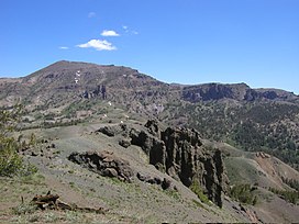
Highland Peak is a prominent 10,936-foot-elevation (3,333-meter) mountain summit located in the Sierra Nevada mountain range, in Alpine County of northern California, United States. It is situated 3.5 miles east of Ebbetts Pass in the Carson-Iceberg Wilderness, on land managed by Humboldt–Toiyabe National Forest. Although it ranks as the 680th-highest summit in California, it ranks 36th-highest of those with at least 500 meters of topographic prominence. Also, there is no higher peak than Highland Peak to the north within the Sierra Nevada. Highland Peak has a subsidiary South Peak, with one-half mile separation between summits. The Pacific Crest Trail traverses the western foot of this mountain, providing an approach option. Precipitation runoff from this mountain drains into tributaries of the East Fork Carson River.. Topographic relief is significant as the summit rises over 2,900 feet above Noble Canyon in 1.6 mile (2.6 km).

Dicks Peak is a 9,974-foot-elevation (3,040 meter) mountain summit located in the Sierra Nevada mountain range in El Dorado County, California, United States. It is the third-highest peak in the Desolation Wilderness, and is set on land managed by Eldorado National Forest. It is situated six miles (9.7 km) south of Lake Tahoe, and approximately eight miles (13 km) west of the community of South Lake Tahoe. Topographic relief is significant as the west aspect rises over 2,300 feet above Rockbound Valley in approximately one mile. One-half mile east of the peak the Pacific Crest Trail and Tahoe Rim Trail traverse Dicks Pass, which provides an approach option for those climbing the peak. Inclusion on the Sierra Peaks Section peakbagging list generates climbing interest.