Sutter Creek, California

Last updated

Sutter Creek
Main Street Sutter Creek.jpg
A view of Main Street (Old Highway 49) in Sutter Creek.
Nickname: 
Jewel of the gold country
Amador County California Incorporated and Unincorporated areas Sutter Creek Highlighted 0677392.svg
Location in Amador County
USA California location map.svg
Red pog.svg
Sutter Creek
Location in California
Usa edcp location map.svg
Red pog.svg
Sutter Creek
Sutter Creek (the United States)
Coordinates: 38°23′35″N120°48′09″W / 38.39306°N 120.80250°W / 38.39306; -120.80250
Country Flag of the United States.svg  United States
State Flag of California.svg  California
County Amador
Settled1848
Incorporated February 11, 1913 [1]
Government
   Mayor Claire Gunselman [2]
   State Senate Angelique Ashby (D) [3]
   State Assembly Joe Patterson (R) [4]
   U. S. Congress Mike Thompson (D) [5]
Area
[6]
  Total2.70 sq mi (6.99 km2)
  Land2.70 sq mi (6.99 km2)
  Water0.00 sq mi (0.00 km2)  0%
Elevation
[7]
1,188 ft (362 m)
Population
 (2010)
  Total2,501
  Estimate 
(2019) [8]
2,622
  Density971.83/sq mi (375.21/km2)
Time zone UTC-8 (PST)
  Summer (DST) UTC-7 (PDT)
ZIP code
95685
Area code 209
FIPS code 06-77392
GNIS feature IDs 277620, 2412019
Website www.cityofsuttercreek.org
Reference no.322 [9]

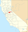
Sutter Creek (formerly spelled Sutter's Creek and Suttercreek; [10] formerly named Suttersville [11] ) is a city in Amador County, California, United States. The population was 2,501 at the 2010 census, up from 2,303 at the 2000 census. It is accessible via State Route 49.

Contents

History

Sutter Creek in 1853 SutterCreek1853.jpg
Sutter Creek in 1853

The community takes its name from nearby Sutter Creek, which in turn has the name of early California developer John Sutter. [12]

Sutter's discovery of gold at nearby Coloma in January 1848 triggered the California Gold Rush. After all his workers left him to go on their own hunts for gold, Sutter moved to Mormon Island with a couple of hands. After about two weeks miners flooded the island, so Sutter and his hands left and returned to Sutter Creek. Sutter said: "I broke up the camp and started on the march further south, and located my next camp on Sutter Creek, now in Amador County, and thought that I should be there alone. The work was going on well for a while, until three or four traveling grog-shops surrounded me, at from one-half to ten miles (16 km) distance from the camp. Then, of course, the gold was taken to these places, for drinking, gambling, etc., and then the following day they were sick and unable to work, and became deeper and more indebted to me, particularly the Kanakas [native Hawaiians]." Shortly thereafter Sutter moved out of Sutter Creek and back to his fort. [13]

Sutter Creek became a destination for fortune hunters. A post office was established in 1852, and Sutter Creek became a town in 1854 [11] that incorporated in 1913. [11]

Although plenty of placer gold was found there, gold-bearing quartz deposits were discovered in 1851, and mining those deposits for gold became the mainstay of the local economy for many years. With the prosperity brought by quartz mining, Sutter Creek became a boomtown. By 1932, the Central Eureka mine, begun in 1869, had reached the 2,300-foot (700 m) level. By 1939, it was the best-paying mine in Sutter Creek. The mines continued operations until 1942, when most gold mines were closed for manpower reasons during World War II.

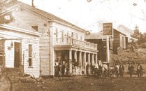
Today, Sutter Creek is a tourist town with many shops and restaurants. The town itself is registered as California Historical Landmark #322. [9]

Geography

According to the United States Census Bureau, the city has a total area of 2.6 square miles (6.6 km2), all of it land.

Climate

According to the Köppen Climate Classification system, Sutter Creek has a hot-summer Mediterranean climate, abbreviated "Csa" on climate maps. [14] Summers are long and hot, while winters are cool but relatively short. As typical of mediterranean climates, precipitation is concentrated to winter months, with summers being extremely dry.

Climate data for Sutter Hill Ranger Station
MonthJanFebMarAprMayJunJulAugSepOctNovDecYear
Record high °F (°C)68
(20)
73
(23)
81
(27)
92
(33)
100
(38)
106
(41)
110
(43)
107
(42)
104
(40)
99
(37)
89
(32)
70
(21)
110
(43)
Mean daily maximum °F (°C)53.8
(12.1)
56.8
(13.8)
61.9
(16.6)
65.7
(18.7)
76.5
(24.7)
86.2
(30.1)
92.9
(33.8)
91.6
(33.1)
86.5
(30.3)
74.7
(23.7)
62.0
(16.7)
54.2
(12.3)
71.9
(22.2)
Daily mean °F (°C)45.9
(7.7)
48.4
(9.1)
51.8
(11.0)
54.6
(12.6)
63.6
(17.6)
71.5
(21.9)
78.0
(25.6)
76.7
(24.8)
72.6
(22.6)
63.0
(17.2)
53.2
(11.8)
46.5
(8.1)
60.5
(15.8)
Mean daily minimum °F (°C)38.0
(3.3)
40.0
(4.4)
41.7
(5.4)
43.7
(6.5)
50.8
(10.4)
57.0
(13.9)
62.8
(17.1)
61.6
(16.4)
58.8
(14.9)
51.3
(10.7)
44.4
(6.9)
38.8
(3.8)
49.1
(9.5)
Record low °F (°C)23
(−5)
26
(−3)
28
(−2)
29
(−2)
31
(−1)
41
(5)
42
(6)
47
(8)
44
(7)
32
(0)
28
(−2)
20
(−7)
20
(−7)
Average precipitation inches (mm)5.19
(132)
4.41
(112)
3.84
(98)
2.76
(70)
1.07
(27)
0.32
(8.1)
0.01
(0.25)
0.12
(3.0)
0.29
(7.4)
1.72
(44)
3.62
(92)
5.22
(133)
28.55
(725)
Average snowfall inches (cm)0.4
(1.0)
0.2
(0.51)
0.1
(0.25)
0
(0)
0
(0)
0
(0)
0
(0)
0
(0)
0
(0)
0
(0)
0
(0)
0.1
(0.25)
0.9
(2.3)
Average precipitation days10109641011471063
Source: Western Regional Climate Center [15]

Demographics

Historical population
CensusPop.Note
1880 1,324
1890 1,3512.0%
1920 920
1930 1,01310.1%
1940 1,13411.9%
1950 1,1511.5%
1960 1,1610.9%
1970 1,50829.9%
1980 1,70513.1%
1990 1,8357.6%
2000 2,30325.5%
2010 2,5018.6%
2019 (est.)2,622 [8] 4.8%
U.S. Decennial Census [16]
Old Route 49 2009-0724-CA-SutterCreek.jpg
Old Route 49

2010

The 2010 United States Census [17] reported that Sutter Creek had a population of 2,501. The population density was 977.8 inhabitants per square mile (377.5/km2). The racial makeup of Sutter Creek was 2,272 (90.8%) White, 10 (0.4%) African American, 34 (1.4%) Native American, 65 (2.6%) Asian, 5 (0.2%) Pacific Islander, 40 (1.6%) from other races, and 75 (3.0%) from two or more races. Hispanic or Latino of any race were 219 persons (8.8%).

The Census reported that 2,500 people (100% of the population) lived in households, 1 (0%) lived in non-institutionalized group quarters, and 0 (0%) were institutionalized.

There were 1,168 households, out of which 258 (22.1%) had children under the age of 18 living in them, 500 (42.8%) were opposite-sex married couples living together, 109 (9.3%) had a female householder with no husband present, 51 (4.4%) had a male householder with no wife present. There were 65 (5.6%) unmarried opposite-sex partnerships, and 15 (1.3%) same-sex married couples or partnerships. 418 households (35.8%) were made up of individuals, and 239 (20.5%) had someone living alone who was 65 years of age or older. The average household size was 2.14. There were 660 families (56.5% of all households); the average family size was 2.77.

The population was spread out, with 466 people (18.6%) under the age of 18, 191 people (7.6%) aged 18 to 24, 426 people (17.0%) aged 25 to 44, 768 people (30.7%) aged 45 to 64, and 650 people (26.0%) who were 65 years of age or older. The median age was 49.4 years. For every 100 females, there were 84.3 males. For every 100 females age 18 and over, there were 83.2 males.

There were 1,367 housing units at an average density of 534.4 per square mile (206.3/km2), of which 1,168 were occupied, of which 626 (53.6%) were owner-occupied, and 542 (46.4%) were occupied by renters. The homeowner vacancy rate was 2.6%; the rental vacancy rate was 14.6%. 1,355 people (54.2% of the population) lived in owner-occupied housing units and 1,145 people (45.8%) lived in rental housing units.

2000

As of the census [18] of 2000, there were 2,303 people, 1,025 households, and 658 families residing in the city. The population density was 1,377.3 inhabitants per square mile (531.8/km2). There were 1,106 housing units at an average density of 661.4 per square mile (255.4/km2). The racial makeup of the city was 91.45% White, 0.22% African American, 1.30% Native American, 1.04% Asian, 0.30% Pacific Islander, 2.13% from other races, and 3.56% from two or more races. Hispanic or Latino of any race were 5.82% of the population.

Of the 1,025 households, 27.0% had children under the age of 18 living with them, 51.2% were married couples living together, 9.7% had a female householder with no husband present, and 35.8% were non-families. 32.1% of all households were made up of individuals, and 18.2% had someone living alone who was 65 years of age or older. The average household size was 2.25 and the average family size was 2.79.

23.2% of residents were under the age of 18, 5.9% from 18 to 24, 20.3% from 25 to 44, 28.1% from 45 to 64, and 22.4% who were 65 years of age or older. The median age was 45 years. For every 100 females, there were 83.4 males. For every 100 females age 18 and over, there were 78.6 males.

The median income for a household in the city was $47,000, and the median income for a family was $55,795. Males had a median income of $46,563 versus $30,188 for females. The per capita income was $23,100. About 4.9% of families and 7.8% of the population were below the poverty line, including 10.5% of those under age 18 and 6.5% of those age 65 or over.

Politics

Sutter Creek Auditorium & City Hall also houses the Police Department. 2009-0724-CA-SutterCreek-CH.jpg
Sutter Creek Auditorium & City Hall also houses the Police Department.
Sutter Creek Inn, Main Street, Sutter Creek Sutter Creek Inn.jpg
Sutter Creek Inn, Main Street, Sutter Creek
Sutter Creek Main Street Sutter Creek Main Street.jpg
Sutter Creek Main Street

In the state legislature Sutter Creek is in the 8th Senate District , represented by Democrat Angelique Ashby, [3] and the 5th Assembly District , represented by Republican Joe Patterson. [4] Federally, Sutter Creek is in California's 5th congressional district , represented by Republican Tom McClintock. [5] The city, as well as Amador County as a whole, consistently votes Republican.

Landmarks

Sutter Creek has two buildings on the National Register of Historic Places

Notable people

High schools

Sutter Creek is home to Amador High School. It has fewer than 1000 students and competes athletically in the Mother Lode League of the CIF Sac-Joaquin Section.

Related Research Articles

<span class="mw-page-title-main">Amador County, California</span> County in California, United States

Amador County is a county located in the U.S. state of California, in the Sierra Nevada. As of the 2020 census, the population was 40,474. The county seat is Jackson. Amador County, located within California's Gold Country, is known as "The Heart of the Mother Lode". There is a substantial viticultural industry in the county.

<span class="mw-page-title-main">Cherryland, California</span> Unincorporated Community in California, United States

Cherryland is an unincorporated community and census-designated place (CDP) in Alameda County, California, United States. Cherryland is located between Ashland to the north and the city of Hayward to the south. The population was 15,808 at the 2020 census.

<span class="mw-page-title-main">Kirkwood, California</span> Place in California, United States

Kirkwood is an unincorporated community in Alpine and Amador counties, California, United States. Kirkwood's main attraction is the Kirkwood Mountain Resort. The town is accessible by State Route 88. Kirkwood is within the Eldorado National Forest. The population was 158 at the 2010 census. For statistical purposes, the United States Census Bureau has defined Kirkwood as a census-designated place (CDP).

<span class="mw-page-title-main">Amador City, California</span> City in California, United States

Amador City is a city in Amador County, California, United States. The population was 200 as of the 2020 Census, up from 185 in 2010, making it the least populous incorporated city in California. Amador City is also noted for being the smallest city in California by area.

<span class="mw-page-title-main">Ione, California</span> City in California, United States

Ione is a city in Amador County, California. As of the 2020 census the population is 5,141, which is a 35.1% decrease from the 2010 census. Once known as "Bed-Bug" and "Freeze Out," Ione was an important supply center on the main road to the Mother Lode and Southern Mines during the California Gold Rush.

<span class="mw-page-title-main">Jackson, California</span> City in California, United States

Jackson is a city in and the county seat of Amador County, California. Its population was 4,651 at the 2010 census, up from 3,989 at the 2000 census. The city is accessible by both State Route 49 and State Route 88.

<span class="mw-page-title-main">Plymouth, California</span> City in California, United States

Plymouth is a city in Amador County, California, United States. The population was 1,005 at the 2010 census. The town was originally named Pokerville, when it was settled during the time of the gold rush. Plymouth is commonly now known as a "Gateway to Shenandoah Valley", a popular wine-producing region in the Sierra foothills. The Ione Band of Miwok Indians, a federally recognized tribe of Miwok people, is headquartered in Plymouth.

<span class="mw-page-title-main">Angels Camp, California</span> City in California, United States

Angels Camp, also known as City of Angels and formerly Angel's Camp, Angels, Angels City, Carson's Creek and Clearlake, is the only incorporated city in Calaveras County, California, United States. The population was 3,836 at the 2010 census, up from 3,004 at the 2000 census. It lies at an elevation of 1378 feet.

<span class="mw-page-title-main">Auberry, California</span> Census-designated place in California, United States

Auberry is a census-designated place (CDP) in Fresno County, California, United States. The population was 2,369 at the 2010 census, up from 2,053 at the 2000 census. Auberry is located on Little Sandy Creek 9.5 miles (15 km) west of Shaver Lake Heights, at an elevation of 2,018 feet (615 m).

<span class="mw-page-title-main">Cantua Creek, California</span> Census-designated place in California, United States

Cantua Creek is a census-designated place (CDP) in Fresno County, California, United States. As of the 2010 census, the population was 466, down from the 655 reported at the 2000 census. Cantua Creek is located 11 miles (18 km) south-southwest of Tranquillity, at an elevation of 295 feet.

<span class="mw-page-title-main">Willow Creek, California</span> Census-designated place in California, United States

Willow Creek is a census-designated place (CDP) in Humboldt County, California, United States. The population was 1,710 at the 2010 census, down from 1,743 at the 2000 census. Residents of this small mountain town are commonly referred to as "Willow Creekers." The town is located around 30 miles (48 km) from county seat and harbor city Eureka, with the two places vastly differing in climate.

<span class="mw-page-title-main">American Canyon, California</span> City in California, United States

American Canyon is a city located in southern Napa County, California, United States, 35 miles (56 km) northeast of San Francisco, part of the San Francisco Bay Area. The 2020 census reported the city's population as 21,837. Its ZIP Code is 94503, and its area code is 707. It is in the Pacific Time time zone and observes Daylight-Saving Time. The city was incorporated in 1992.

<span class="mw-page-title-main">Folsom, California</span> City in California, United States

Folsom is a city in Sacramento County, California, United States. The population was 80,454 at the 2020 census.

<span class="mw-page-title-main">Loyalton, California</span> City in California, United States

Loyalton is a city in Sierra County, California, United States. At the 2020 census, the population was 740, reflecting a decline of 29 from the 769 counted in 2010. The ZIP code for the community is 96118. The town is near the north extent of State Route 49, which ends at State Route 70 in Vinton. According to Rand-McNally, it is a fifty-mile drive on State Route 49 to the county seat, Downieville. Many of the population are ranchers, loggers, former loggers, or suburbanites who have relocated from the San Francisco Bay Area, Sacramento, and growing Reno–Tahoe area.

<span class="mw-page-title-main">Graton, California</span> Census-designated place in California, United States

Graton is an unincorporated town and census-designated place (CDP) in west Sonoma County, California, United States. The population was 1,707 at the 2010 census. Graton's ZIP code is 95444. The town also has a culinary reputation attributed to two restaurants in the area.

<span class="mw-page-title-main">Live Oak, Sutter County, California</span> City in California, United States

Live Oak is an incorporated city in Sutter County, California, United States. It is part of the Yuba City Metropolitan Statistical Area within the Greater Sacramento CSA, and includes a hamlet historically named Stafford. The population was 9,106 at the 2020 census, up from 8,392 at the 2010 census.

<span class="mw-page-title-main">Sutter, California</span> Census-designated place in California, United States

Sutter, formerly South Butte and Sutter City, is a census-designated place (CDP) in Sutter County, California, United States. It is part of the Yuba City Metropolitan Statistical Area within the Greater Sacramento CSA. The population as of the 2010 census was 2,904, up from 2,885 at the 2000 census.

<span class="mw-page-title-main">Myrtle Creek, Oregon</span> City in Oregon, United States

Myrtle Creek is a city in Douglas County, Oregon, United States. The population was 3,439 at the 2010 census.

<span class="mw-page-title-main">Long Creek, Oregon</span> City in Oregon, United States

Long Creek is a city in Grant County, Oregon, United States. The population was 173 at the 2020 census. The city is named after John Long, a prominent miner who came to Grant County in 1862 during the Canyon City rush of that same year. Located in a high valley of the Blue Mountains, ranching has been the principal enterprise for the area. Log harvesting was slowly curtailed in the nearby Malheur National Forest until the local mill was closed in 1998.

Nicolaus is a census-designated place (CDP) in Sutter County, California. Nicolaus is part of the Yuba City Metropolitan Statistical Area. Nicolaus sits at an elevation of 26 feet (7.9 m). The 2010 United States census reported Nicolaus's population was 211.

References

  1. "California Cities by Incorporation Date". California Association of Local Agency Formation Commissions. Archived from the original (Word) on February 21, 2013. Retrieved March 27, 2013.
  2. "City Council" . Retrieved January 10, 2023.
  3. 1 2 "Senators". State of California. Retrieved March 18, 2013.
  4. 1 2 "Members Assembly". State of California. Retrieved March 18, 2013.
  5. 1 2 "California's 5th Congressional District - Representatives & District Map". Civic Impulse, LLC. Retrieved April 10, 2023.
  6. "2019 U.S. Gazetteer Files". United States Census Bureau. Retrieved July 1, 2020.
  7. "Sutter Creek". Geographic Names Information System . United States Geological Survey, United States Department of the Interior . Retrieved May 24, 2007.
  8. 1 2 "Population and Housing Unit Estimates". United States Census Bureau. May 24, 2020. Retrieved May 27, 2020.
  9. 1 2 "Sutter Creek". Office of Historic Preservation, California State Parks. Retrieved October 6, 2012.
  10. U.S. Geological Survey Geographic Names Information System: Sutter Creek, California
  11. 1 2 3 Durham, David L. (1998). California's Geographic Names: A Gazetteer of Historic and Modern Names of the State. Clovis, Calif.: Word Dancer Press. p. 565. ISBN   1-884995-14-4.
  12. "Historic Sutter Creek". City of Sutter Creek. Archived from the original on August 26, 2017. Retrieved March 27, 2018.{{cite web}}: CS1 maint: bot: original URL status unknown (link)
  13. Mason, J.D. (1881). History of Amador County, California. Oakland, California: Thompson & West. ISBN   978-0-938121-07-7.
  14. Climate Summary for Sutter Creek, California
  15. "Sutter Hill CDF, California". Western Regional Climate Center. Desert Research Institute. Retrieved May 20, 2020.
  16. "Census of Population and Housing". Census.gov. Retrieved June 4, 2015.
  17. "2010 Census Interactive Population Search: CA - Sutter Creek city". U.S. Census Bureau. Archived from the original on July 15, 2014. Retrieved July 12, 2014.
  18. "U.S. Census website". United States Census Bureau . Retrieved January 31, 2008.
  19. Perovich, Edyth. "National Register of Historical Places Inventory" (PDF). Sierra Nevada Geotourism. Archived from the original (PDF) on November 4, 2019.
  20. Greenbaum, Toni (1996). Eidelberg, Martin P. (ed.). Messengers of Modernism: American Studio Jewelry 1940-1960. Montreal Museum of Decorative Arts. Montreal Museum of Decorative Arts. p. 112. ISBN   978-2-08-013593-3.
  21. Storms, A. D. (1901). The Players Blue Book. Worcester, MA: Sutherland & Storms. pp.  258-259.