The Sierra Nevada is a mountain range in the Western United States, between the Central Valley of California and the Great Basin. The vast majority of the range lies in the state of California, although the Carson Range spur lies primarily in Nevada. The Sierra Nevada is part of the American Cordillera, an almost continuous chain of mountain ranges that forms the western "backbone" of the Americas.

The John Muir Trail (JMT) is a long-distance trail in the Sierra Nevada mountain range of California, passing through Yosemite, Kings Canyon and Sequoia National Parks. It is named after John Muir, a naturalist.

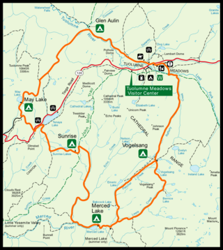
Tuolumne Meadows is a gentle, dome-studded, sub-alpine meadow area along the Tuolumne River in the eastern section of Yosemite National Park in the United States. Its approximate location is 37°52.5′N119°21′W. Its approximate elevation is 8,619 feet (2,627 m). The term Tuolumne Meadows is also often used to describe a large portion of the Yosemite high country around the meadows, especially in context of rock climbing.
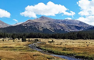
Mount Dana is a mountain in the U.S. state of California. Its summit marks the eastern boundary of Yosemite National Park and the western boundary of the Ansel Adams Wilderness. At an elevation of 13,061 feet (3,981 m), it is the second highest mountain in Yosemite, and the northernmost summit in the Sierra Nevada which is over 13,000 feet (3,962.4 m) in elevation. Mount Dana is the highest peak in Yosemite that accessible to summit. The mountain is named in honor of James Dwight Dana, who was a professor of natural history and geology at Yale.

Kings Canyon National Park is a national park of the United States in the southern Sierra Nevada, in Fresno and Tulare Counties, California. Originally established in 1890 as General Grant National Park, the park was greatly expanded and renamed on March 4, 1940. The park's namesake, Kings Canyon, is a rugged glacier-carved valley more than a mile (1,600 m) deep. Other natural features include multiple 14,000-foot (4,300 m) peaks, high mountain meadows, swift-flowing rivers, and some of the world's largest stands of giant sequoia trees. Kings Canyon is north of and contiguous with Sequoia National Park, and both parks are jointly administered by the National Park Service as the Sequoia and Kings Canyon National Parks.
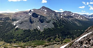
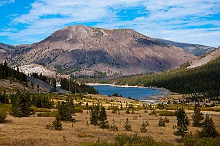
Mount Gibbs is located in the Sierra Nevada of the U.S. state of California, 2.6 miles (4 km) south of Mount Dana. The mountain was named in honor of Oliver Gibbs, a professor at Harvard University and friend of Josiah Whitney. The summit marks the boundary between Yosemite National Park and the Ansel Adams Wilderness, and Mount Gibbs is the sixth-highest mountain, of Yosemite.

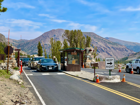
State Route 120 is a state highway in the central part of California, connecting the San Joaquin Valley with the Sierra Nevada, Yosemite National Park, and the Mono Lake area. Its western terminus is at Interstate 5 in Lathrop, and its eastern terminus is at U.S. Route 6 in Benton. While the route is signed as a contiguous route through Yosemite, the portion inside the park is federally maintained and is not included in the state route logs. The portion at Tioga Pass at Yosemite's eastern boundary is the highest paved through road in the California State Route system. This part is not maintained in the winter and is usually closed during the winter season.

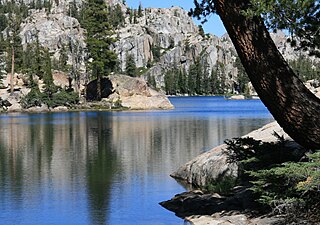
Tenaya Lake is an alpine lake in Yosemite National Park, located between Yosemite Valley and Tuolumne Meadows. The surface of Tenaya Lake has an elevation of 8,150 feet (2,484 m). The lake basin was formed by glacial action, which left a backdrop of light granite rocks, whose beauty was known to the Native Americans. Today, Tenaya Lake is easily accessible by State Route 120 and is a popular lake for water activities.
The Emigrant Wilderness of Stanislaus National Forest is a formally designated wilderness area in the Sierra Nevada. It is bordered by Yosemite National Park on the south, the Toiyabe National Forest and the Hoover Wilderness on the east, and State Route 108 over Sonora Pass on the north. It is an elongated area that extends northeast about 25 miles (40 km) in length and up to 15 miles (24 km) in width. Watersheds drain to the Stanislaus and Tuolumne Rivers. The Emigrant Wilderness area, which is a glaciated landscape, is entirely within Tuolumne County, California and is approximately 140 miles (230 km) east of San Francisco, California and 50 miles (80 km) south of Lake Tahoe.

Mount Lyell is the highest point in Yosemite National Park, at 13,114 feet (3,997 m). It is located at the southeast end of the Cathedral Range, 1+1⁄4 miles northwest of Rodgers Peak. The peak as well as nearby Lyell Canyon is named after Charles Lyell, a well-known 19th century geologist. The peak had one of the last remaining glaciers in Yosemite, Lyell Glacier. The Lyell Glacier is currently considered to be a permanent ice field, not a living glacier. Mount Lyell divides the Tuolumne River watershed to the north, the Merced to the west, and the Rush Creek drainage in the Mono Lake Basin to the southeast.

State Route 168 is an east-west state highway in the U.S. state of California that is separated into two distinct segments by the Sierra Nevada. The western segment runs from State Routes 41 and 180 in Fresno east to Huntington Lake along the western slope of the Sierra. The eastern segment connects Lake Sabrina in the Eastern Sierra to State Route 266 in the community of Oasis, just to the west of the Nevada border. The eastern segment of SR 168 also forms a concurrency with U.S. Route 395 between Bishop and Big Pine.

The High Sierra Trail (HST) is a hiking trail in Sequoia National Park, California. The trail crosses the Sierra Nevada from west to east. According to the Yosemite Decimal System, the HST is a Class 1/Class 2 trail, which means simple scrambling, with the possibility of occasional use of the hands for balance.

Sonora Pass is a mountain pass in the Sierra Nevada in California. It is the second-highest pass with a road in California and in the Sierra Nevada. It is 321 feet (98 m) lower than Tioga Pass to the south. State Route 108 traverses the pass, as does the Pacific Crest Trail.
The High Sierra Camps are nine rustic lodging facilities located in two national parks and a national monument in California's Sierra Nevada mountain range. Open most years from June or July to September, they are staffed camps with tent cabins and food service facilities. The backcountry camps receive their supplies by pack mules.

The Tahoe–Yosemite Trail (TYT) is a long-distance trail in the Sierra Nevada mountain range of California. The trail courses 186 miles (299 km) from Meeks Bay at Lake Tahoe to Tuolumne Meadows in Yosemite National Park. The trail is a foot and equestrian path that passes through the Desolation, Mokelumne, Carson-Iceberg, Emigrant, and Yosemite Wilderness Areas and the Meiss Country (Dardanelles) Roadless Area.
Hiking, rock climbing, and mountain climbing around Tuolumne Meadows in Yosemite National Park has many options.
Tioga Peak is located in Mono County, California, approximately two miles outside of Yosemite National Park. It is situated in the Hoover Wilderness on land managed by Inyo National Forest.
False White Mountain is a mountain, in the northern part of Yosemite National Park. It is the 24th highest mountain, in Yosemite National Park. False White Mountain can be climbed, as a day hike, from Tioga Pass.

Gaylor Peak is an 11,004-foot (3,354-meter) mountain summit located on the crest of the Sierra Nevada mountain range in northern California, United States. The peak is positioned on the boundary between Yosemite National Park and the Inyo National Forest, and it also lies on the border between Mono County and Tuolumne County. The peak rises prominently above Tioga Pass and Tioga Lake, with a notable topographic relief, as the summit stands approximately 1,400 feet above the lake within a distance of one-half mile (0.80 km).