Yosemite National Park is a national park of the United States in California. It is bordered on the southeast by Sierra National Forest and on the northwest by Stanislaus National Forest. The park is managed by the National Park Service and covers 759,620 acres in four counties – centered in Tuolumne and Mariposa, extending north and east to Mono and south to Madera. Designated a World Heritage Site in 1984, Yosemite is internationally recognized for its granite cliffs, waterfalls, clear streams, groves of giant sequoia, lakes, mountains, meadows, glaciers, and biological diversity. Almost 95 percent of the park is designated wilderness. Yosemite is one of the largest and least fragmented habitat blocks in the Sierra Nevada.
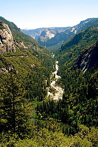
Yosemite Valley is a glacial valley in Yosemite National Park in the western Sierra Nevada mountains of Central California, United States. The valley is about 7.5 mi (12.1 km) long and 3,000–3,500 ft (910–1,070 m) deep, surrounded by high granite summits such as Half Dome and El Capitan, and densely forested with pines. The valley is drained by the Merced River, and a multitude of streams and waterfalls flow into it, including Tenaya, Illilouette, Yosemite and Bridalveil Creeks. Yosemite Falls is the highest waterfall in North America and is a big attraction, especially in the spring, when the water flow is at its peak. The valley is renowned for its natural environment and is regarded as the centerpiece of Yosemite National Park.

Tuolumne Meadows is a gentle, dome-studded, sub-alpine meadow area along the Tuolumne River in the eastern section of Yosemite National Park in the United States. Its approximate location is 37°52.5′N119°21′W. Its approximate elevation is 8,619 feet (2,627 m). The term Tuolumne Meadows is also often used to describe a large portion of the Yosemite high country around the meadows, especially in context of rock climbing.

The Merced River, in the central part of the U.S. state of California, is a 145-mile (233 km)-long tributary of the San Joaquin River flowing from the Sierra Nevada into the San Joaquin Valley. It is most well known for its swift and steep course through the southern part of Yosemite National Park, where it is the primary watercourse flowing through Yosemite Valley. The river's character changes dramatically once it reaches the plains of the agricultural San Joaquin Valley, where it becomes a slow-moving meandering stream.

State Route 140 is a state highway in the U.S. state of California, 102 miles (164 km) in length. It begins in the San Joaquin Valley at Interstate 5 near Gustine, and runs east into Sierra Nevada, terminating in Yosemite National Park.

Glacier Point is a viewpoint above Yosemite Valley in the U.S. state of California. It is located on the south wall of Yosemite Valley at an elevation of 7,214 feet (2,199 m), 3,200 feet (980 m) above Curry Village. The point offers a superb view of several of Yosemite National Park's well-known landmarks, including Yosemite Valley, Yosemite Falls, Half Dome, Vernal Fall, Nevada Fall, and Clouds Rest. Between 1872 and 1968, it was the site of the Yosemite Firefall.

Human habitation in the Sierra Nevada region of California reaches back 8,000 to 10,000 years ago. Historically attested Native American populations, such as the Sierra Miwok, Mono and Paiute, belong to the Uto-Aztecan and Utian phyla. In the mid-19th century, a band of Native Americans called the Ahwahnechee lived in Yosemite Valley. The California Gold Rush greatly increased the number of non-indigenous people in the region. Tensions between Native Americans and white settlers escalated into the Mariposa War. As part of this conflict, settler James Savage led the Mariposa Battalion into Yosemite Valley in 1851, in pursuit of Ahwaneechees led by Chief Tenaya. The California state military forces burned the tribe's villages, destroyed their food stores, killed the chief's sons, and forced the tribe out of Yosemite. Accounts from the Mariposa Battalion, especially from Dr. Lafayette Bunnell, popularized Yosemite Valley as a scenic wonder.

The ecology of the Sierra Nevada, located in the U.S. states of California and Nevada, is diverse and complex. The combination of climate, topography, moisture, and soils influences the distribution of ecological communities across an elevation gradient from 500 to 14,500 feet. Biotic zones range from scrub and chaparral communities at lower elevations, to subalpine forests and alpine meadows at the higher elevations. Particular ecoregions that follow elevation contours are often described as a series of belts that follow the length of the Sierra Nevada. There are many hiking trails, paved and unpaved roads, and vast public lands in the Sierra Nevada for exploring the many different biomes and ecosystems.

Little Yosemite Valley is a smaller glacial valley upstream in the Merced River drainage from the Yosemite Valley in Yosemite National Park. The Merced River meanders through the 3.5 mi (5.6 km) long flat valley, draining out over Nevada Fall and Vernal Fall before emptying into the main Yosemite Valley. It can be reached by a day hike from the main valley, and is the most popular area in the Yosemite Wilderness. The Valley provides access to nearby destinations such as the back side of Half Dome, Clouds Rest and the High Sierra Camp at Merced Lake.
Merced Falls is an unincorporated community in Merced County, California. It is located on the north bank of the Merced River 6 miles (9.7 km) east of Snelling, at an elevation of 348 feet . Merced Falls was named for a set of rapids on the Merced River.

The Yosemite Valley Railroad (YVRR) was a short-line railroad that operated in California from 1907 to 1945, providing a new mode of travel and tourism for the region. It ran from Merced to the Yosemite National Park, but it did not extend to Yosemite Valley itself, as railroad construction was prohibited in the National Parks. Tourists would disembark at the park boundary in El Portal, California and stay overnight at the Hotel Del Portal before taking a stagecoach to Yosemite Valley.
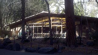
Yosemite Lodge at the Falls, often referred to informally within the Park as "The Lodge" is located in western Yosemite Village, Yosemite National Park, Mariposa County, California. The lodging accommodation is close to Yosemite Falls.

The 1996 Yosemite Valley landslide occurred on July 10, 1996, near the Happy Isles trailhead in Yosemite Valley, Yosemite National Park, Mariposa County, California. 162,000 tons of rocks and other debris fell to the ground at over 160 miles per hour. Of the 12 campers/hikers involved in the incident, one was killed. The landslide competes with the 1997 Merced River flood and the 2013 Rim wildfire for the designation of the worst natural disaster in Yosemite to date. The earthquake caused by the rock slide was followed almost immediately by a sonic boom. Soon afterward a granite dust mushroom cloud formed over Happy Isles. The immense pressure created at the base of the rock slide blew down giant pine trees. Afterwards the nearby campground tables and trees were covered with a thick coat of granite dust.

The Christmas flood of 1964 was a major flood in the United States' Pacific Northwest and some of Northern California between December 18, 1964, and January 7, 1965, spanning the Christmas holiday.

The Yosemite Valley Bridges are eight bridges in the Yosemite Valley of Yosemite National Park, most of them spanning the Merced River. Five of them were built in 1928, with the remainder built between 1921 and 1933. The bridges feature a concrete structure faced with local stone, in an elliptical or three-centred arch configuration. They are notable for their uniform character and for their conformance to tenets of the National Park Service rustic style. Design work for the seven newer bridges was by George D. Whittle of the San Francisco District Office of the U.S. Bureau of Public Roads for the National Park Service. Concrete bridges were chosen at the urging of Thomas Chalmers Vint of the Park Service, in lieu of alternative designs for steel truss bridges, or suspension bridges suggested by the park superintendent.

The Wawona Covered Bridge is a covered bridge spanning the South Fork Merced River near Wawona, California, in Yosemite National Park. The open bridge was built by Galen Clark, the steward of what was then called the Yosemite Grant, in 1868, without its cladding. The open bridge was a component of Clark's proposed new road from Wawona to the Yosemite Valley. Clark was unable to complete the road, which he sold to the Washburn Group of investors along with his stopover lodging in 1874. In mid-1875 the Washburn Group completed the road to Yosemite Valley. It is one of twelve remaining covered bridges in California.

Flooding in 2017 affected parts of California in the first half of the year. Northern California saw its wettest winter in almost a century, breaking the record set in 1982–83. The same storm systems also flooded parts of western Nevada and southern Oregon. The damage was estimated at $1.55 billion ($1,926,663,046 today), including damage to California roads and highways estimated at more than $1.05 billion.
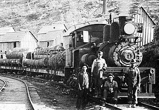
The Yosemite Lumber Company was an early 20th century Sugar Pine and White Pine logging operation in the Sierra Nevada. The company built the steepest logging incline ever, a 3,100 feet (940 m) route that tied the high-country timber tracts in Yosemite National Park to the low-lying Yosemite Valley Railroad running alongside the Merced River. From there, the logs went by rail to the company’s sawmill at Merced Falls, about fifty-four miles west of El Portal.

Periods of heavy rainfall caused by multiple atmospheric rivers in California between December 31, 2022, and March 25, 2023, resulted in floods that affected parts of Southern California, the California Central Coast, Northern California and Nevada. The flooding resulted in property damage and at least 22 fatalities. At least 200,000 homes and businesses lost power during the December-January storms and 6,000 individuals were ordered to evacuate.

The 1997 California New Years Floods resulted from a series of winter storms, from December 26 to January 3 of 1997, fed with tropical moisture by an atmospheric river. It impacted Northern California, resulting in some of the most devastating flooding since the Great Flood of 1862. Similarly to the 1862 event, the flooding was a combined effect of heavy rainfall and excessive snowmelt of the relatively large early-season Sierra Nevada snowpack. The resulting flooding in the Central Valley and other low-lying areas forced over 120,000 people from their homes and caused over $2 billion in property damage alone. 48 out of California's 58 counties were declared disaster areas with many streamflow gauge stations in these areas recording return intervals of over 100 years. It would take months for the worst-hit areas to recover fully.