California State Route 140

Last updated • 4 min readFrom Wikipedia, The Free Encyclopedia

California 140.svg
State Route 140
California State Route 140.svg
SR 140 highlighted in red
Route information
Maintained by Caltrans
Length101.645 mi [1]  (163.582 km)
SR 140 is broken into pieces, and the length does not reflect the overlaps that would be required to make the route continuous.
Tourist
routes
California Scenic State.svg SR 140 between Mariposa and El Portal [2]
Major junctions
West endI-5 (1961).svg I-5 near Gustine
Major intersections
East end Yosemite National Park
Location
Country United States
State California
Counties Merced, Mariposa
Highway system
California 139.svg SR 139 California 142.svg SR 142

State Route 140 (SR 140) is a state highway in the U.S. state of California, 102 miles (164 km) in length. It begins in the San Joaquin Valley at Interstate 5 near Gustine, and runs east into Sierra Nevada, terminating in Yosemite National Park.

Contents

Route description

Ferguson Slide Ferguson-slide.jpg
Ferguson Slide
A stretch west of El Portal California highway 140.jpg
A stretch west of El Portal
SR 140 from Yosemite National Park to Midpines Yosemite CA-140 IMG IMG 20180410 160759.jpg
SR 140 from Yosemite National Park to Midpines
Eastbound SR 140 just east of Merced, California California State Route 140 East Of Merced.jpg
Eastbound SR 140 just east of Merced, California

Heading east from I-5, the highway passes Gustine; it then jogs to cross the San Joaquin River. It roughly marks the southern edge of the farmable land around Livingston. It intersects with State Route 99 in Merced, which it overlaps for a few miles. Travelers coming from most regions of the San Francisco Bay Area or other parts of Northern California to Yosemite Valley and the southern portion of Yosemite would transfer from Highway 99 to Highway 140 at this point. For those coming from San Jose and the rest of the Silicon Valley, the most direct, fastest route is State Route 152 east; then the roads of Road 9, Bliss Road, Sandy Mush Road, and Plainsburg Road to reach Highway 140 in Planada. (Those going to the northern portion of Yosemite would have instead taken either I-580 and I-205 leaving the Bay Area, then State Route 120 east through Manteca, or State Route 132 east through Modesto.)

After exiting Highway 99, Highway 140 continues through Planada, after which the farmland gives way to grazing land. It is quite dry in the summer due to California's Mediterranean climate, and the dry grass gives the landscape a golden color. Western meadowlarks, American kestrels, red-tailed hawks and turkey vultures are frequently glimpsed. A few blue oaks can be seen as the highway leaves the valley and begins to climb through the foothills of the Sierra Nevada. They become more and more numerous as the elevation increases. As the highway passes through Catheys Valley the vegetation begins to diversify a little. California live oaks and ponderosa pines intermingle with the blue oaks as it nears Mariposa. In Mariposa, it briefly runs concurrently with State Route 49.

A ponderosa pine forest borders the highway on both sides as it passes through Midpines. As it approaches Briceburg, the roadway follows a steep, winding grade down to the Merced River valley. The highway then runs alongside the Merced River for about 20 miles (32 km) to the Yosemite National Park entrance, after passing through El Portal. The upper stretch of the Merced River valley below the park, which the highway follows, is designated as Wild and Scenic River Area. The area separates Sierra National Forest (south) and Stanislaus National Forest (north).

Inside Yosemite, state routes are federally maintained and are not included in the state route logs. The highway continues into the park as El Portal Drive, following the Merced River to Yosemite Valley. The road intersects with Big Oak Flat Road, providing a connection to State Route 120. El Portal Drive then splits into a one way loop road to connect the rest of the valley, heading east as Southside Drive on the south side of the river and then looping back west as Northside Drive on the north side of the river. State Route 41/Wawona Road intersects with Southside Drive just east of the split.

SR 140 is part of the California Freeway and Expressway System, [3] and is part of the National Highway System, [4] a network of highways that are considered essential to the country's economy, defense, and mobility by the Federal Highway Administration. [5] SR 140 is eligible to be included in the State Scenic Highway System; [6] however, only the part of the road from Mariposa to El Portal is designated as a scenic highway. [7]

History

The "All-Weather Highway" (now State Route 140) opened in 1926, ensuring year-long visitation and delivery of supplies under normal conditions.[74] NPS 1989, p. 113. In June 2006, the road between El Portal and Mariposa was closed due to a rock slide. The Ferguson Slide buried about 600 feet (180 m) of SR140 between Cedar Lodge and Briceburg Visitor Center between SR-49 and SR-41. [8]

A small detour opened in August, 2006, with a traffic light system to allow drivers to circumvent the original slide damage area. Plans are underway for construction of a rock shed through the slide area to restore the original alignment.

The road was closed in 2018 due to the Ferguson Fire.

Major intersections

Except where prefixed with a letter, postmiles were measured on the road as it was in 1964, based on the alignment that existed at the time, and do not necessarily reflect current mileage. R reflects a realignment in the route since then, M indicates a second realignment, L refers to an overlap due to a correction or change, and T indicates postmiles classified as temporary (for a full list of prefixes, see California postmile § Official postmile definitions ). [1] Segments that remain unconstructed or have been relinquished to local control may be omitted. The numbers reset at county lines; the start and end postmiles in each county are given in the county column.

CountyLocationPostmile
[1] [9] [10]
Exit
[11]
DestinationsNotes
Merced 0.00Sullivan RoadContinuation beyond I-5
0.00I-5 (1961).svg I-5 (West Side Freeway) Sacramento, Los Angeles Interchange; west end of SR 140; I-5 exit 418
Gustine 4.35South plate California.svg
California 33.svg
SR 33 south / Sullivan Road
West end of SR 33 overlap
6.06North plate California.svg
California 33.svg
SR 33 north / First Avenue Newman, Tracy
East end of SR 33 overlap
16.22California 165.svg SR 165 (Lander Avenue) Stevinson, Hilmar, Turlock, Los Banos
23.43Lincoln Boulevard – Livingston
29.47Applegate Road – Atwater
Merced 35.81
15.77 [N 1]
North plate California.svg
California 99.svg
North plate California.svg
California 59.svg
SR 99 north / SR 59 north (V Street) Sacramento, Sonora
Interchange; west end of SR 99 / SR 59 overlap; SR 99 south exit 188
West end of freeway on SR 99
14.69 [N 1] 187BSouth plate California.svg
California 59.svg
SR 59 south (Martin Luther King Jr. Way) Downtown Merced, Los Banos
East end of SR 59 overlap
14.41 [N 1] 187AG StreetWestbound exit and eastbound entrance
13.86 [N 1]
35.82
East end of freeway on SR 99
South plate California.svg
California 99.svg
SR 99 south / 16th Street (SR 99 Bus. north) Los Angeles
Interchange; east end of SR 99 overlap; SR 99 north exit 186B
38.26To plate California.svg
California 99.svg
Campus Parkway Access to SR 99
Connects to Campus Parkway
Planada 43.70Plainsburg Road – Le Grand, Madera, Fresno
Mariposa Catheys Valley 9.50Hornitos Road – Hornitos
Mariposa 21.22South plate California.svg
California 49.svg
SR 49 south Oakhurst
West end of SR 49 overlap
22.00North plate California.svg
California 49.svg
SR 49 north / Jones Street Coulterville, Sonora
East end of SR 49 overlap
Yosemite National Park 51.80East end of state maintenance at western park boundary
Arch Rock Entrance Station; park fee or pass required for entry [12]
To plate California.svg
California 120.svg
Big Oak Flat Road to SR 120 (Tioga Road) Manteca
Northside DriveEntrance only
South plate California.svg
California 41.svg
SR 41 south (Wawona Road) Wawona, Fresno
Eastbound access only
Southside Drive – Yosemite Valley DestinationsContinuation beyond SR 41; westbound entrance only accessible via Northside Drive
1.000 mi = 1.609 km; 1.000 km = 0.621 mi
  1. 1 2 3 4 Indicates that the postmile represents the distance along SR 99 rather than SR 140.

See also

Related Research Articles

<span class="mw-page-title-main">California State Route 152</span> East-west highway in central California

State Route 152 is a state highway that runs from east to west near the middle of the U.S. state of California from State Route 1 in Watsonville to State Route 99 southeast of Merced. Its western portion provides access to and from Interstate 5 toward Southern California for motorists in or near Gilroy and San Jose.

<span class="mw-page-title-main">California State Route 99</span> State highway in California, United States

State Route 99 (SR 99) is a major north–south state highway in the U.S. state of California, stretching almost the entire length of the Central Valley. From its southern end at Interstate 5 (I-5) near Wheeler Ridge to its northern end at SR 36 near Red Bluff, SR 99 goes through the densely populated eastern parts of the valley. Cities served include Bakersfield, Delano, Tulare, Visalia, Fresno, Madera, Merced, Turlock, Modesto, Manteca, Stockton, Sacramento, Yuba City, and Chico.

<span class="mw-page-title-main">California State Route 120</span> Highway in California

State Route 120 is a state highway in the central part of California, connecting the San Joaquin Valley with the Sierra Nevada, Yosemite National Park, and the Mono Lake area. Its western terminus is at Interstate 5 in Lathrop, and its eastern terminus is at U.S. Route 6 in Benton. While the route is signed as a contiguous route through Yosemite, the portion inside the park is federally maintained and is not included in the state route logs. The portion at Tioga Pass at Yosemite's eastern boundary is the highest paved through road in the California State Route system. This part is not maintained in the winter and is usually closed during the winter season.

The State Scenic Highway System in the U.S. state of California is a list of highways, mainly state highways, that have been designated by the California Department of Transportation (Caltrans) as scenic highways. They are marked by the state flower, a California poppy, inside either a rectangle for state-maintained highways or a pentagon for county highways.

<span class="mw-page-title-main">California State Route 126</span> Highway in California

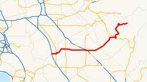
State Route 126 is a state highway in the U.S. state of California that serves Ventura and Los Angeles counties. The route runs from U.S. Route 101 in Ventura to Interstate 5 at the Castaic Junction-Santa Clarita border through the Santa Clara River Valley. The highway is an important connector highway in Ventura County, and serves as an alternate route into the Santa Clarita Valley, and the San Fernando Valley area of Los Angeles and the High Desert of Antelope Valley.

<span class="mw-page-title-main">California State Route 35</span> Highway in California

State Route 35, generally known as Skyline Boulevard for most of its length, is a mostly two-lane state highway in the U.S. state of California. It runs along the ridge of the Santa Cruz Mountains from the high point of State Route 17 near Lexington Reservoir in Santa Clara County to State Route 1 just south of Daly City in San Mateo County, where it crosses SR 1 and loops around Lake Merced to become Sloat Boulevard in San Francisco. SR 35 then continues along Sloat Boulevard until it reaches its terminus when it meets SR 1 again at 19th Avenue.

<span class="mw-page-title-main">California State Route 116</span> Highway in California

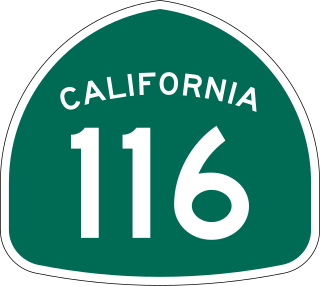
State Route 116 (SR 116) is a state highway in the U.S. state of California in Sonoma County. The route runs from SR 1 on the Pacific coast near Jenner to SR 121 south of Sonoma.

<span class="mw-page-title-main">California State Route 49</span> Highway in California

State Route 49 is a north–south state highway in the U.S. state of California that passes through many historic mining communities of the 1849 California gold rush and it is known as the Golden Chain Highway. The road was initially lobbied in 1919 by the Mother Lode Highway Association, a group of locals and historians. The highway begins at State Route 41 in Oakhurst, Madera County, in the Sierra Nevada. It continues in a generally northwest direction, weaving through the communities of Goldside and Ahwahnee, before crossing into Mariposa County. State Route 49 then continues northward through the counties of Tuolumne, Calaveras, Amador, El Dorado, Placer, Nevada, Yuba, Sierra, and Plumas, where it reaches its northern terminus at State Route 70, in Vinton.

<span class="mw-page-title-main">California State Route 12</span> State highway in California, United States

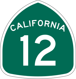
State Route 12 is a state highway in the U.S. state of California that travels in an east–west direction from State Route 116 in Sebastopol in Sonoma County to State Route 49 just north of San Andreas in Calaveras County. The route connects the Sonoma and Napa valleys with the Sacramento–San Joaquin River Delta and the Sierra Foothills. It is constructed to freeway standards from the Fulton Road/South Wright Road stoplight in Santa Rosa, to its partial interchange with Farmers Lane.

<span class="mw-page-title-main">California State Route 4</span> State highway in California

State Route 4 is a state highway in the U.S. state of California, routed from Interstate 80 in the San Francisco Bay Area to State Route 89 in the Sierra Nevada. It roughly parallels the Sacramento-San Joaquin River Delta, a popular area for boating and fishing, with a number of accesses to marinas and other attractions. After crossing the Central Valley, the highway ascends up the Sierra foothills. It passes through Ebbetts Pass and contains the Ebbetts Pass Scenic Byway, a National Scenic Byway.

<span class="mw-page-title-main">California State Route 41</span> Highway in California

State Route 41 is a state highway in the U.S. State of California, connecting the Central Coast with the San Joaquin Valley and the Sierra Nevada. Its southern terminus is at the Cabrillo Highway in Morro Bay, and its northern terminus is at SR 140 in Yosemite National Park. It has been constructed as an expressway from near SR 198 in Lemoore north to the south part of Fresno, where the Yosemite Freeway begins, passing along the east side of downtown and extending north into Madera County.

<span class="mw-page-title-main">California State Route 33</span> Highway in California

State Route 33 is a north–south state highway in the U.S. state of California. It runs north from U.S. Route 101 in Ventura through the Transverse Ranges and the western side of the San Joaquin Valley to Interstate 5 at a point east of Tracy. SR 33 replaced part of U.S. Route 399 in 1964 during the "great renumbering" of routes. In the unincorporated sections of Kern County it is known as the West Side Highway. In addition, the California Legislature designated the entire Kern County portion as the Petroleum Highway in 2004. The southernmost portion in Ventura is a freeway known as the Ojai Freeway, while it is known as the Maricopa Highway from Ojai to Maricopa.

<span class="mw-page-title-main">California State Route 165</span> Highway in California

State Route 165 is a rural north–south state highway in the U.S. state of California. It runs in the San Joaquin Valley from Interstate 5 south of Los Banos to State Route 99 in Turlock.

<span class="mw-page-title-main">California State Route 132</span> Highway in California

State Route 132 is a state highway in the U.S. state of California that connects the Central Valley with the Sierra Nevada foothills and the California Gold Country. Its western segment also connects the city of Modesto with the San Francisco Bay Area via I-580, although this route is discouraged due to it being a two-lane road between Modesto and Interstate 5. East of Modesto, the road climbs the foothills and eventually ends at SR 49 at Coulterville.

<span class="mw-page-title-main">California State Route 166</span> Highway in California

State Route 166 is a state highway in the U.S. state of California. It connects the Central Coast to the southern San Joaquin Valley, running from State Route 1 in Guadalupe and through Santa Maria in Santa Barbara County to State Route 99 in Mettler in Kern County.

<span class="mw-page-title-main">California State Route 108</span> Highway in California

State Route 108 is a state highway in the U.S. state of California that runs from the Central Valley and across the Sierra Nevada via the Sonora Pass. It generally runs northeast from downtown Modesto near the SR 99/SR 132 interchange, to U.S. Route 395 near the Nevada state line. The route was once recommended to continue south of Modesto to Interstate 5, although today that portion exists as a county road. Parts of SR 108 are closed annually during the winter due to inclement weather along the summit.

<span class="mw-page-title-main">California State Route 127</span> Highway in California

State Route 127 is a state highway in the U.S. state of California that connects Interstate 15 in Baker to Nevada State Route 373 at the Nevada state line, passing near the eastern boundary of Death Valley National Park. The entire length of the highway closely follows the central portion of the former Tonopah and Tidewater Railroad and loosely follows the Amargosa River.

<span class="mw-page-title-main">California State Route 180</span> Highway in California

State Route 180 is a state highway in the U.S. state of California. It runs through the heart of the San Joaquin Valley from State Route 33 in Mendota through Fresno, and then east towards the Sierra Nevada to Kings Canyon National Park.

<span class="mw-page-title-main">California State Route 178</span> Highway in California

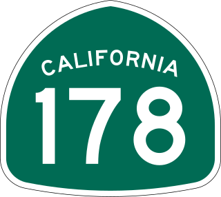
State Route 178 is a state highway in the U.S. state of California that exists in two constructed segments. The gap in between segments is connected by various local roads and State Route 190 through Death Valley National Park. The western segment runs from State Route 99 in Bakersfield and over the Walker Pass in the Sierra Nevada to the turnoff for the Trona Pinnacles National Natural Landmark. The eastern segment runs from the southeasterly part of Death Valley to Nevada State Route 372 at the Nevada state line.

<span class="mw-page-title-main">Ferguson landslide</span> Landslide in Mariposa County, California

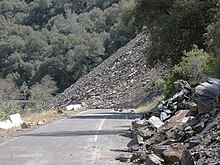
The Ferguson landslide, also commonly called the Ferguson Slide, is an active landslide in the Merced River canyon in Mariposa County, California, United States. In 2006, rocks and debris slid off Ferguson Ridge, blocking California State Route 140, a primary access road to Yosemite National Park. The slide still blocked the original road as of June 2024, although temporary bridges allow one-way traffic around the slide and into the park. The slide is a natural phenomenon, and resulted from the erosion dynamics of the river valley.

References

  1. 1 2 3 California Department of Transportation. "State Truck Route List". Sacramento: California Department of Transportation. Archived from the original (XLS file) on September 5, 2015. Retrieved June 30, 2015.
  2. California Department of Transportation (August 2019). "Officially Designated State Scenic Highways and Historic Parkways" (XLSX). Sacramento: California Department of Transportation. Retrieved March 27, 2019.
  3. "Article 2 of Chapter 2 of Division 1". California Streets and Highways Code. Sacramento: California Office of Legislative Counsel. Retrieved February 6, 2019.
  4. Federal Highway Administration (March 25, 2015). National Highway System: California (North) (PDF) (Map). Scale not given. Washington, DC: Federal Highway Administration. Retrieved September 27, 2017.
  5. Natzke, Stefan; Neathery, Mike & Adderly, Kevin (June 20, 2012). "What is the National Highway System?". National Highway System. Washington, DC: Federal Highway Administration. Retrieved July 1, 2012.
  6. "Article 2.5 of Chapter 2 of Division 1". California Streets & Highways Code. Sacramento: California Office of Legislative Counsel. Retrieved February 6, 2019.
  7. California Department of Transportation (August 2019). "Officially Designated State Scenic Highways and Historic Parkways" (XLSX). Sacramento: California Department of Transportation. Retrieved September 27, 2017.
  8. "Ferguson Rock Slide" (PDF). Archived from the original (PDF) on August 10, 2006.
  9. California Department of Transportation (July 2007). "Log of Bridges on State Highways". Sacramento: California Department of Transportation.
  10. California Department of Transportation, All Traffic Volumes on CSHS, 2005 and 2006
  11. California Department of Transportation, California Numbered Exit Uniform System, State Route 99 Freeway Interchanges, Retrieved on 2009-02-14.
  12. "Yosemite National Park Fees & Passes". National Park Service. Retrieved December 31, 2021.
Template:Attached KML/California State Route 140
KML is from Wikidata