Yosemite National Park is an American national park in California, surrounded on the southeast by Sierra National Forest and on the northwest by Stanislaus National Forest. The park is managed by the National Park Service and covers an area of 759,620 acres and sits in four counties – centered in Tuolumne and Mariposa, extending north and east to Mono and south to Madera County. Designated a World Heritage Site in 1984, Yosemite is internationally recognized for its granite cliffs, waterfalls, clear streams, giant sequoia groves, lakes, mountains, meadows, glaciers, and biological diversity. Almost 95 percent of the park is designated wilderness.
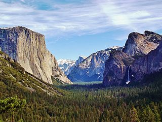
Yosemite Valley is a glacial valley in Yosemite National Park in the western Sierra Nevada mountains of Central California. The valley is about 7.5 mi (12.1 km) long and 3,000–3,500 ft (910–1,070 m) deep, surrounded by high granite summits such as Half Dome and El Capitan, and densely forested with pines. The valley is drained by the Merced River, and a multitude of streams and waterfalls flow into it, including Tenaya, Illilouette, Yosemite and Bridalveil Creeks. Yosemite Falls is the highest waterfall in North America and is a big attraction especially in the spring, when the water flow is at its peak. The valley is renowned for its natural environment and is regarded as the centerpiece of Yosemite National Park.

The exposed geology of the Yosemite area includes primarily granitic rocks with some older metamorphic rock. The first rocks were laid down in Precambrian times, when the area around Yosemite National Park was on the edge of a very young North American continent. The sediment that formed the area first settled in the waters of a shallow sea, and compressive forces from a subduction zone in the mid-Paleozoic fused the seabed rocks and sediments, appending them to the continent. Heat generated from the subduction created island arcs of volcanoes that were also thrust into the area of the park. In time, the igneous and sedimentary rocks of the area were later heavily metamorphosed.

The Ahwahnechee are a Native American people who traditionally lived in the Yosemite Valley and still live in surrounding area. They are the seven tribes of Yosemite Miwok, Northern Paiute, Kucadikadi Mono Lake people. As one of the most documented tribes the tribe still fights for Federal Recognition. The Ahwahnechee people's heritage can be found all over Yosemite National Park.
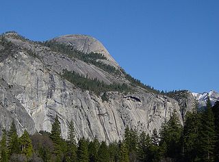
North Dome is a granite dome in Yosemite National Park, California. It is the southernmost summit of Indian Ridge, 0.6 miles (1.0 km) north of Washington Column and the Royal Arches on the northeastern wall of Yosemite Valley. It can be reached by trail from the Tioga Pass Road, or by going up the Yosemite Falls trail and heading east. It can also be reached from Mirror Lakes by the Snow Creek Falls trail going north around Indian Rock and then south again on the Tioga Pass Road trail. The South Face is precipitous.
Tenaya was a leader of the Ahwahnechee people in Yosemite Valley, California.

Tenaya Lake is an alpine lake in Yosemite National Park, located between Yosemite Valley and Tuolumne Meadows. The surface of Tenaya Lake has an elevation of 8,150 feet (2,484 m). The lake basin was formed by glacial action, which left a backdrop of light granite rocks, whose beauty was known to the Native Americans. Today, Tenaya Lake is easily accessible by State Route 120 and is a popular lake for water activities.
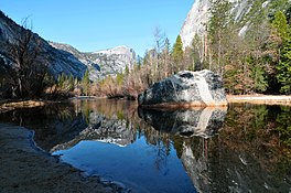
Tenaya Canyon is a dramatic and dangerous canyon in Yosemite National Park, California, USA, that runs from the outlet of Tenaya Lake 10 miles down to Yosemite Valley, carrying water in Tenaya Creek through a series of spectacular cascades and pools and thence into a deep canyon below Cloud's Rest, a giant granite mountain adjacent to Half Dome. Waterfalls on the creek inside the canyon include Pywiack Cascade and Three Chute Falls, near Mirror Lake.
Olmsted Point is a viewing area off Tioga Pass Road in Yosemite National Park which offers a view south into Tenaya Canyon, giving, in particular, a view of the northern side of Half Dome, Clouds Rest, and a view of Tenaya Lake to the east. The granite slopes immediately south and southwest of the parking lot feature numerous glacial erratics scattered about, as well as a short 0.125 mi (0.2 km) trail leading south - through a small grove of trees - to the top of a small granite dome where the view of Clouds Rest and Half Dome is clearest.

Three Chute Falls is a waterfall on Tenaya Creek in Yosemite National Park, in the U.S. state of California.
The Pywiack Cascade is a waterfall in Yosemite National Park within the U.S. state of California. It is located a few miles downstream from the outlet of Tenaya Lake on Tenaya Creek at the head of the steep and rugged granite gorge, Tenaya Canyon. The waterfall can be viewed from Glacier Point, or by a 6-mile (9.7 km) hike from Olmsted Point, but the canyon is dangerous and the waterfall is unsafe to be reached on foot. The waterfall is highly seasonal. It typically rages in the spring and early summer while shrinking to a trickle by late summer to mid-autumn.

The Yosemite Valley Bridges are eight bridges in the Yosemite Valley of Yosemite National Park, most of them spanning the Merced River. Five of them were built in 1928, with the remainder built between 1921 and 1933. The bridges feature a concrete structure faced with local stone, in an elliptical or three-centered arch configuration. They are notable for their uniform character and for their conformance to tenets of the National Park Service rustic style. Design work for the seven newer bridges was by George D. Whittle of the San Francisco District Office of the U.S. Bureau of Public Roads for the National Park Service. Concrete bridges were chosen at the urging of Thomas Chalmers Vint of the Park Service, in lieu of alternative designs for steel truss bridges, or suspension bridges suggested by the park superintendent.
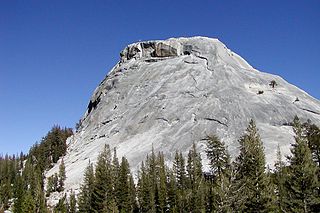
Pywiack Dome is a prominent 600 foot granite dome in Yosemite National Park, located 0.7 miles (1.1 km) north-east of Tenaya Lake, 4 miles (6.4 km) west of Tuolumne Meadows and 200 feet (61.0 m) from the Tioga Road. It is quite near Harlequin Dome, and North and South Whizz Domes are north.
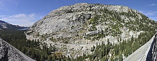
Polly Dome is a prominent granite dome rising 1,640 feet (500 m) above the northwest side of Tenaya Lake and Tioga Road in the Yosemite high country. The dome, more than 3 kilometers long, is a substantially intact mass of granitic rock that has withstood heavy glaciation and exfoliation. Forest clings to the less-steep parts of its north and west slopes. The southwest end of Polly Dome consists of the Stately Pleasure Dome, 740 feet (230 m) lower than Polly Dome, but rising very steeply 900 feet (270 m) from the shore of the lake. Polly Dome's summit has unobstructed views east to the Cathedral Range, north over Tuolumne Meadows to the Sierra crest, northwest over the Grand Canyon of the Tuolumne and southwest to Half Dome.

Stately Pleasure Dome is the unofficial name for the prominent south-southwestern portion of Polly Dome, a granite dome on the northwest side of Tenaya Lake and Tioga Road in the Yosemite high country. Stately Pleasure Dome consists of glaciated and exfoliated granite rock that rises steeply 900 feet (270 m) from the lake shore; the very steep east side of the dome is popular with rock climbers, who gave the dome its name.

Tenaya Peak is a mountain in the Yosemite high country, rising above Tenaya Lake. Tenaya Peak is named after Chief Tenaya, who met the Mariposa Battalion near the shores of the Tenaya lake. In 1851, the Mariposa Battalion under Captain John Boling expelled Chief Tenaya and his people from what was to become Yosemite National Park.
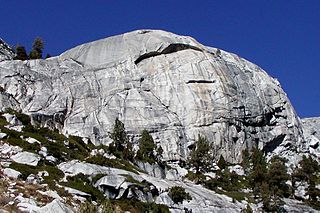
Harlequin Dome is a granite dome, quite near Tenaya Lake, in the Tuolumne Meadows region of Yosemite National Park.
Mariolumne Dome is a granite dome, in the Tuolumne Meadows region of Yosemite National Park.
Doda Dome is a granite dome west of the Tuolumne Meadows area of Yosemite National Park, to the northeast of Tenaya Lake. It is a high dome, just northwest of Daff Dome, and may be identified by its mammalian appearance. It is named after Carol Doda, a famous Bay Area stripper.

West Quarter Dome is a granodiorite dome, in the Tenaya Canyon area of Yosemite National Park. It is composed of Half Dome Granodiorite.