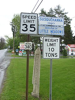
Little Meadows is a borough in Susquehanna County, Pennsylvania, United States. The population was 273 at the 2010 census.
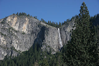
Silver Strand Falls drops 574 feet (175m) along Meadow Brook, at the western end of Yosemite Valley, within Yosemite National Park. The falls are commonly thought to drop 1170 feet (356m); this is incorrect. The name Widow's Tears had been applied to Silver Strand Falls in the past, but the lower-volume waterfall located one drainage to the east of Meadow Brook is now known as Widow's Tears and is thought to drop 1,170 feet (360 m), hence the confusion regarding the height.

The Hoover Wilderness is a wilderness area in the Inyo and Humboldt-Toiyabe National Forests. It lies to the east of the crest of the central Sierra Nevada in California, to the north and east of Yosemite National Park - a long strip stretching nearly to Sonora Pass on the north and Tioga Pass on the south.
Shuswap Lake Marine Provincial Park is an 896-hectare provincial park in British Columbia, Canada, comprising 991 ha. The Park has a variety of amenities including boat launch ramps, picnic areas, and 27 campsites around the perimeter of Shuswap Lake. The lake's name and that of the surrounding Shuswap Country is from the Shuswap people (Secwepemc), the most northern of the Salishan speaking people.

KMGV is located in the Fresno, California area and broadcasts at 97.9 FM. It is owned by Cumulus Media. Its studios are located at the Radio City building on Shaw Avenue in North Fresno and its transmitter is at Meadow Lakes in Sierra National Forest.

KLBN is a commercial radio station located in Fresno, California, broadcasting on 101.9 FM. KLBN airs a Regional Mexican music format branded as "La Buena". Its studios are located just north of downtown Fresno, and the transmitter tower is in Meadow Lakes in the Sierra National Forest.
Buck Meadows is a census-designated place in Mariposa County, California. It is located 2 miles (3.2 km) east-northeast of Smith Peak, at an elevation of 3015 feet. The population was 31 at the 2010 census.
Olmsted Point, located in Yosemite National Park, is a viewing area off of the Tioga Road which offers a view into Tenaya Canyon. This view looks southwest into the valley, giving, in particular, a view of the northern side of Half Dome and a view of Tenaya Lake to the east.
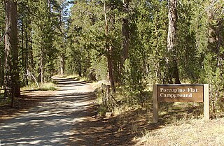
Porcupine Flat Campground, located in northern area of Yosemite National Park along Tioga Road, is a first-come first-served campground outside of Yosemite Valley. This campground is very remote, very quiet, and very unpopulated relative to other campgrounds in Yosemite. The campground is directly off the road and thus does not require a rough drive to the campground like other Yosemite campgrounds outside of the Valley. Porcupine Flat is directly along a branch of Snow Creek and therefore many of the sites inside the campground are directly alongside a running creek. Those looking to stay away from crowds/noise should consider this campground. The sites are very green and shaded by the trees in the area. Deer are often seen grazing in the campground.
South Williamson is a census-designated place (CDP) in the Appalachian Mountains of northeastern Pike County, Kentucky, United States, on the border with West Virginia. It is separated from Williamson, West Virginia by the Tug Fork River. The community is located near U.S. Route 119 about 23 miles (37 km) east of Pikeville, Kentucky and 28 miles (45 km) southwest of Logan, West Virginia.

A seagull intersection or continuous green T-intersection is a type of three-way road intersection, usually used on high traffic volume roads and dual carriageways. This form of intersection is popular in Australia and New Zealand, and sometimes used in the United States and other countries.
The McConnell State Recreation Area is on the banks of the Merced River, about two miles northeast of Livingston. Fishing is popular for catfish, black bass and perch. There are picnic, camping and play areas.

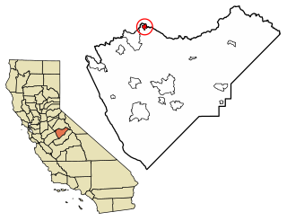
Meadow Lakes is an unincorporated community in Fresno County, California. It is located 6.5 miles (10 km) west-southwest of Shaver Lake Heights, at an elevation of 4452 feet.
Piedra is an unincorporated community in Fresno County, California. It is located on the south bank of the Kings River 23 miles (37 km) east of Fresno, at an elevation of 538 feet.

Ruthless Records Tenth Anniversary: Decade of Game is a compilation album released by Ruthless Records. The album featured some of the label's greatest hits from the previous ten years. It peaked at 119 on the Billboard 200 and 44 on the Top R&B/Hip-Hop Albums.

Demmitt is a hamlet in northern Alberta, Canada within the County of Grande Prairie No. 1. It is located on Highway 43, approximately 77 kilometres (48 mi) northwest of Grande Prairie. The Northern Alberta Railway was built through the area in 1930 as it extended westwards towards Dawson Creek, British Columbia.

Burt Castle is a ruined castle located close to Newtowncunningham and Burt, County Donegal, Ireland. Historically it was sometimes spelt as Birt Castle. It is also known by the name O'Doherty's Castle, and should not be mistaken for O'Doherty's Castle near Buncrana.


