
Yosemite National Park is an American national park in the western Sierra Nevada of Central California, bounded on the southeast by Sierra National Forest and on the northwest by Stanislaus National Forest. The park is managed by the National Park Service and covers an area of 748,436 acres and sits in four counties: centered in Tuolumne and Mariposa, extending north and east to Mono and south to Madera County. Designated a World Heritage Site in 1984, Yosemite is internationally recognized for its granite cliffs, waterfalls, clear streams, giant sequoia groves, lakes, mountains, meadows, glaciers, and biological diversity. Almost 95% of the park is designated wilderness.
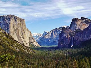
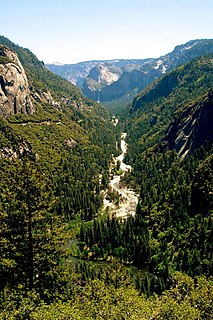
Yosemite Valley is a glacial valley in Yosemite National Park in the western Sierra Nevada mountains of Central California. The valley is about 7.5 miles (12 km) long and approximately 3000–3500 feet deep, surrounded by high granite summits such as Half Dome and El Capitan, and densely forested with pines. The valley is drained by the Merced River, and a multitude of streams and waterfalls flow into it, including Tenaya, Illilouette, Yosemite and Bridalveil Creeks. Yosemite Falls is the highest waterfall in North America and is a big attraction especially in the spring, when the water flow is at its peak. The valley is renowned for its natural environment and is regarded as the centerpiece of Yosemite National Park, attracting visitors from around the world.

Yosemite Valley is a census-designated place (CDP) in Mariposa County, California, United States. It consists of the developed area of Yosemite Village and the other areas of the Yosemite Valley in Yosemite National Park. The population was 1,035 at the 2010 census, up from 265 at the 2000 census.

The National Park Service (NPS) is an agency of the federal government of the United States that manages all national parks, many national monuments, and other conservation and historical properties with various title designations. The United States Congress created the agency on August 25, 1916 through the National Park Service Organic Act.

The Mist Trail is one of the most popular short hikes in Yosemite National Park, California, USA. The steep hike follows the Merced River, starting at Happy Isles in Yosemite Valley, past Vernal Fall and Emerald Pool, to Nevada Fall.

The Merced River, in the central part of the U.S. state of California, is a 145-mile (233 km)-long tributary of the San Joaquin River flowing from the Sierra Nevada into the San Joaquin Valley. It is most well known for its swift and steep course through the southern part of Yosemite National Park, where it is the primary watercourse flowing through Yosemite Valley. The river's character changes dramatically once it reaches the plains of the agricultural San Joaquin Valley, where it becomes a slow-moving meandering stream.

Human habitation in the Sierra Nevada region of California reaches back 8,000 to 10,000 years ago. Historically attested Native American populations, such as the Sierra Miwok, Mono and Paiute, belong to the Uto-Aztecan and Utian phyla. In the mid-19th century, a band of Native Americans called the Ahwahnechee lived in Yosemite Valley. The California Gold Rush greatly increased the number of non-indigenous people in the region. Tensions between Native Americans and white settlers escalated into the Mariposa War. As part of this conflict, settler James Savage led the Mariposa Battalion into Yosemite Valley in 1851, in pursuit of Ahwaneechees led by Chief Tenaya. The California state military forces burned the tribe's villages, destroyed their food stores, killed the chief's sons, and forced the tribe out of Yosemite. Accounts from the Mariposa Battalion, especially from Dr. Lafayette Bunnell, popularized Yosemite Valley as a scenic wonder.

Delaware North is a global food service and hospitality company headquartered in Buffalo, New York. The company also operates in the lodging, sporting, airport, gambling and entertainment industries. The company employs over 55,000 people worldwide and has over $3.2 billion in annual revenues.

The Ahwahnee Hotel is a grand hotel in Yosemite National Park, California, on the floor of Yosemite Valley. It was built by the Yosemite Park and Curry Company and opened for business in 1927. The hotel is constructed from steel, stone, concrete, wood, and glass, and is a premier example of National Park Service rustic architecture. It was declared a National Historic Landmark in 1987.

The Wawona Hotel is a historic hotel located within southern Yosemite National Park, in California. It was declared a National Historic Landmark in 1987, and is on the National Register of Historic Places.

Badger Pass Ski Area is a small ski area located within Yosemite National Park. Badger Pass is one of only three lift serviced ski areas operating in a US National Park. It is situated five miles (8 km) south-southeast of the Chinquapin intersection of Wawona Road with Glacier Point Road in the southern area of Yosemite National Park. Glacier Point Road provides the access to this ski area. During high snow level and/or ski season, Glacier Point road terminates at Badger Pass Ski Resort. Under these conditions, the remainder of Glacier Point Road is used for cross-country skiing access to Glacier Point and other destinations in the high country.

Located in the Yosemite Valley, Housekeeping Camp is one of the more inexpensive lodging options for visitors to Yosemite National Park. The camp is open from April through October and is one of the most popular places to stay in the valley. Reservations typically fill up on the first day they become available. The original design of the camp was intended to provide a camping-like experience for visitors who did not want to have to provide their own equipment.

National Park Service rustic – sometimes colloquially called Parkitecture – is a style of architecture that developed in the early and middle 20th century in the United States National Park Service (NPS) through its efforts to create buildings that harmonized with the natural environment. Since its founding in 1916, the NPS sought to design and build visitor facilities without visually interrupting the natural or historic surroundings. The early results were characterized by intensive use of hand labor and a rejection of the regularity and symmetry of the industrial world, reflecting connections with the Arts and Crafts movement and American Picturesque architecture. Architects, landscape architects and engineers combined native wood and stone with convincingly native styles to create visually appealing structures that seemed to fit naturally within the majestic landscapes. Examples of the style can be found in numerous types of National Park structures, including entrance gateways, hotels and lodges, park roads and bridges, visitor centers, trail shelters, informational kiosks, and even mundane maintenance and support facilities. Many of these buildings are listed on the National Register of Historic Places.

Curry Village is a resort in Mariposa County, California in Yosemite National Park within the Yosemite Valley.
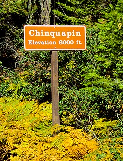
Chinquapin is a former settlement in Mariposa County, California. It was located 8.5 miles (14 km) north-northwest of Wawona. It is located within Yosemite National Park, adjacent to the community of Yosemite West. Chinquapin is the midway point between Yosemite Valley and Wawona, a community inside the park.
The January 1997 flood of the Merced River occurred from December 31, 1996, to January 5, 1997, throughout the Yosemite Valley in Yosemite National Park, Mariposa County, California, US. The flood stands as arguably the park's worst natural disaster to date, and inarguably the worst flood in park history. The Merced River at Happy Isles peaked at 10,100 cubic feet per second during the flood. A book was written on the flood later in 1997 by Mark Goodin titled Yosemite: The 100-Year Flood.

The Yosemite Valley Bridges are eight bridges in the Yosemite Valley of Yosemite National Park, most of them spanning the Merced River. Five of them were built in 1928, with the remainder built between 1921 and 1933. The bridges feature a concrete structure faced with local stone, in an elliptical or three-centered arch configuration. They are notable for their uniform character and for their conformance to tenets of the National Park Service rustic style. Design work for the seven newer bridges was by George D. Whittle of the San Francisco District Office of the U.S. Bureau of Public Roads for the National Park Service. Concrete bridges were chosen at the urging of Thomas Chalmers Vint of the Park Service, in lieu of alternative designs for steel truss bridges, or suspension bridges suggested by the park superintendent.

The High Sierra Camps are nine rustic lodging facilities located in two national parks and a national monument in California's Sierra Nevada mountain range. Open most years from June or July to September, they are staffed camps with tent cabins and food service facilities. The backcountry camps receive their supplies by pack mules.
In 1993, Delaware North became the provider of visitor services at Yosemite National Park under contract with the National Park Service, via the subsidiary DNC Parks and Resorts at Yosemite, Inc.

The Panorama Trail is a marked hiking trail in Yosemite National Park that descends along the south wall of Yosemite Valley from Glacier Point, past several major waterfalls, to Happy Isles. The trail derives its name from the panoramic vistas visible along the route, most notably Panorama Point.


