Mount Gibbs is located in the Sierra Nevada of the U.S. state of California, 2.6 miles (4 km) south of Mount Dana. The mountain was named in honor of Oliver Gibbs, a professor at Harvard University and friend of Josiah Whitney. The summit marks the boundary between Yosemite National Park and the Ansel Adams Wilderness, and Mount Gibbs is the sixth-highest mountain, of Yosemite.

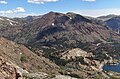
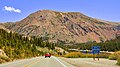
Tioga Pass is a mountain pass in the Sierra Nevada mountain range of California. State Route 120 runs through it, and serves as the eastern entry point for Yosemite National Park, at the Tioga Pass Entrance Station. It is the highest elevation highway pass in California and in the Sierra Nevada at an elevation of 9,945 ft (3,031 m). Mount Dana is to the east of the pass, and Gaylor Peak to the west.

State Route 120 is a state highway in the central part of California, connecting the San Joaquin Valley with the Sierra Nevada, Yosemite National Park, and the Mono Lake area. Its western terminus is at Interstate 5 in Lathrop, and its eastern terminus is at U.S. Route 6 in Benton. While the route is signed as a contiguous route through Yosemite, the portion inside the park is federally maintained and is not included in the state route logs. The portion at Tioga Pass at Yosemite's eastern boundary is the highest paved through road in the California State Route system. This part is not maintained in the winter and is usually closed during the winter season.

Lee Vining is an unincorporated community and census-designated place (CDP) in Mono County, California, United States. It is located 25 miles (40 km) south-southeast of Bridgeport. Lee Vining is located on the southwest shore of Mono Lake. The population was 217 as of the 2020 census.

Lee Vining Creek is a 16.2-mile-long (26.1 km) stream in Mono County, California, flowing into the endorheic basin of Mono Lake. It is the second largest stream flowing into the lake, after Rush Creek.

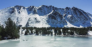
Mount Baldwin is a 12,614-foot-elevation (3,845-meter) mountain summit located in the Sierra Nevada mountain range in Mono County of northern California, United States. It is situated in the John Muir Wilderness on land managed by Inyo National Forest. It is four miles north of Red and White Mountain, and approximately 10.5 miles (16.9 km) southeast of the community of Mammoth Lakes. The nearest higher neighbor is Red Slate Mountain, 2 miles (3.2 km) to the south-southwest. Baldwin ranks as the 257th highest summit in California. Topographic relief is significant as the east aspect rises 3,775 feet above McGee Canyon in 1.5 mile. The first ascent of the summit was made July 2, 1928, by Norman Clyde, who is credited with 130 first ascents, most of which were in the Sierra Nevada.
Gabbro Peak is an 11,033-foot-elevation (3,363-meter) mountain summit located in the Sierra Nevada mountain range, in Mono County of northern California, United States. The mountain is set in the Hoover Wilderness on land managed by Humboldt–Toiyabe National Forest. The peak is situated one mile outside the boundary of Yosemite National Park, approximately three miles northwest of Virginia Lakes, one-half mile north of Page Peaks, and 2.2 miles (3.5 km) west-northwest of Dunderberg Peak. Topographic relief is significant as the north aspect rises over 2,000 feet above Green Lake in one-half mile. Gabbro Peak may be climbed from East Lake, or via the Virginia Pass Trail.

Kettle Peak is a mountain with a summit elevation of 11,010 feet (3,356 m) located in the Sierra Nevada mountain range, in Mono County of northern California, United States. The summit is set in the Hoover Wilderness on land managed by Humboldt–Toiyabe National Forest, and is less than one-half mile outside the boundary of Yosemite National Park. The peak is situated approximately three miles southwest of Twin Lakes, three miles south of Victoria Peak, 2.9 miles northeast of Crown Point, and 3.1 miles northwest of Matterhorn Peak. Topographic relief is significant as the west aspect rises over 2,600 feet above Robinson Creek in one mile.
Black Mountain is an 11,797-foot-elevation (3,596 meter) summit located in the Sierra Nevada mountain range, in Mono County of northern California, United States. The mountain is set within the Hoover Wilderness, on the common boundary shared by Inyo National Forest with Humboldt–Toiyabe National Forest, and 1.5 mile outside the boundary of Yosemite National Park. The peak is situated immediately southwest above Virginia Lakes, 1.8 miles (2.9 km) northeast of line parent Excelsior Mountain, and 1.8 miles (2.9 km) south of Dunderberg Peak. Topographic relief is significant as the north aspect rises 1,500 feet above Cooney Lake in one-half mile (0.80 km), and the south aspect rises 3,600 feet above Lundy Canyon in one and a half miles (2.4 km). The first ascent of the summit was made in 1905 by George R. Davis, Albert Hale Sylvester, and Pearson Chapman, all with the United States Geological Survey.

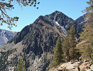
Camiaca Peak is an 11,739-foot-elevation (3,578 meter) mountain summit located on the crest of the Sierra Nevada mountain range in northern California, United States. The peak is situated on the common boundary shared by Yosemite National Park with Hoover Wilderness, as well as the border shared by Mono County with Tuolumne County. It is approximately two miles east of Virginia Peak, three miles west of Dunderberg Peak, and Summit Lake lies at the base of the southeast slope. Topographic relief is significant as the west aspect rises nearly 2,000 feet above Return Creek in three-quarters mile.

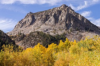
Gaylor Peak is an 11,004-foot (3,354-meter) mountain summit located on the crest of the Sierra Nevada mountain range in northern California, United States. The peak is positioned on the boundary between Yosemite National Park and the Inyo National Forest, and it also lies on the border between Mono County and Tuolumne County. The peak rises prominently above Tioga Pass and Tioga Lake, with a notable topographic relief, as the summit stands approximately 1,400 feet above the lake within a distance of one-half mile (0.80 km).

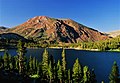
Mount Warren is a 12,327-foot-elevation (3,757 meter) summit located in the Sierra Nevada mountain range, in Mono County, California, United States. The mountain is set within the Hoover Wilderness, on land managed by Inyo National Forest. The peak is situated 1.5 miles (2.4 km) south of Gilcrest Peak, 1.8 miles (2.9 km) northwest of Lee Vining Peak, and 5 miles (8.0 km) southeast of Excelsior Mountain, which is the nearest higher neighbor. Topographic relief is significant as the summit rises 5,955 feet above Mono Lake in 4.5 miles.
Mount Scowden is an 11,182-foot-elevation (3,408 meter) summit located in the Sierra Nevada mountain range, in Mono County of northern California, United States. The mountain is set less than three miles east of the Sierra crest, within the Hoover Wilderness, on land managed by Inyo National Forest. Mount Scowden is situated in Lundy Canyon, one mile north of line parent Tioga Crest, 1.6 miles (2.6 km) west of Gilcrest Peak, and 2.5 miles (4.0 km) southeast of Black Mountain. Topographic relief is significant as the summit rises 2,900 feet above Mill Creek in one mile. Precipitation runoff from this mountain drains to Mill Creek, and ultimately Mono Lake. The mountain's toponym has been officially adopted by the United States Board on Geographic Names and has been in publications since at least 1882. Leo A. Scowden was a mining engineer and United States deputy mineral surveyor for California who resided in Bodie, Mono County. There were several mining claims on Mt. Scowden in the 1800s which gave rise to the gold rush camp of Lundy.

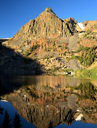
Lee Vining Peak is an 11,690-foot-elevation (3,563 meter) summit located in the Sierra Nevada mountain range, in Mono County of northern California, United States. The mountain is set within the Hoover Wilderness, on land managed by Inyo National Forest. The peak is situated north of Lee Vining Canyon, and 1.8 miles (2.9 km) southeast of Mount Warren, which is the nearest higher neighbor. Topographic relief is significant as the summit rises 5,300 feet above Mono Lake in less than four miles (6.4 km), and 4,000 feet above Lee Vining Creek in two miles (3.2 km).
Page Peaks is a 10,929-foot-elevation (3,331 meter) mountain summit located in the Sierra Nevada mountain range, in Mono County of northern California, United States. The mountain is set in the Hoover Wilderness on land managed by Humboldt–Toiyabe National Forest. The summit is situated one mile outside the boundary of Yosemite National Park, and less than one mile east of line parent Camiaca Peak. Topographic relief is significant as the east aspect rises 1,400 feet above East Lake in one-quarter mile. This landform's toponym, which commemorates a miner and prospector named Page, has been officially adopted by the United States Board on Geographic Names.

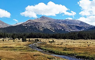
Mount Lewis is a 12,350-foot-elevation mountain summit located along the crest of the Sierra Nevada mountain range, in Mono County of northern California, United States. It is situated in the Ansel Adams Wilderness, on land managed by Inyo National Forest. The summit lies less than one mile outside of Yosemite National Park's eastern boundary, and some of the lower western slope lies within the park. The mountain rises 1.8 miles (2.9 km) southeast of Mono Pass, 1.5 miles (2.4 km) northeast of Parker Pass, and two miles north of Parker Peak, which is the nearest higher neighbor. Topographic relief is significant as it rises over 5,200 feet above Grant Lake in four miles which makes the mountain visible from Highway 395.
Hawksbeak Peak is a mountain summit with an elevation of 11,134 feet (3,394 m) located on the crest of the Sierra Nevada mountain range, in northern California, United States. The granitic summit is situated on the common boundary shared by Yosemite National Park with Hoover Wilderness, as well as the common border of Mono County and Tuolumne County. This remote peak is set at the head of Thompson Canyon, approximately eight miles west of Twin Lakes and 17 miles southwest of Bridgeport, the nearest town. Topographic relief is significant as the west aspect rises over 1,300 feet in less than one-quarter mile. The class 5.10- West Face was first climbed in September 1989 by Alan Swanson and John Nye. This landform's toponym has been officially adopted by the U.S. Board on Geographic Names.

Gale Peak is a 10,690-foot-elevation (3,258 meter) mountain summit located in Madera County, California, United States. It is situated in the Sierra Nevada mountain range, in the southeast corner of Yosemite National Park, on the common boundary which the park shares with the Ansel Adams Wilderness. The mountain rises 1.3 miles (2.1 km) south of Fernandez Pass, 4.5 miles (7.2 km) south of the Clark Range, and 2.2 miles (3.5 km) north-northwest of Madera Peak. Precipitation runoff from this landform drains west into tributaries of the South Fork Merced River, and east into tributaries of the San Joaquin River. Topographic relief is significant as the summit rises 1,400 feet above Upper Chain Lake in 0.38 miles (0.61 km). The peak can be climbed via the class 2 northwest ridge which separates Breeze Lake from the Chain Lakes.

Mount Wood is a 12,657-foot-elevation (3,858 meter) mountain summit located just east of the crest of the Sierra Nevada mountain range, in Mono County of northern California, United States. It is situated in the Ansel Adams Wilderness, on land managed by Inyo National Forest. It is approximately 6.0 miles (9.7 km) northwest of the community of June Lake, two miles outside of Yosemite National Park's eastern boundary, and one mile east-southeast of line parent Parker Peak. Topographic relief is significant as the summit rises over 5,500 feet above Grant Lake in three miles. The mountain is visible from the June Lake Loop.