
Mount Whitney is the highest mountain in the contiguous United States and the Sierra Nevada, with an elevation of 14,505 feet (4,421 m). It is in East–Central California, on the boundary between California's Inyo and Tulare counties, and 84.6 miles (136.2 km) west-northwest of North America's lowest point, Badwater Basin in Death Valley National Park, at 282 ft (86 m) below sea level. The mountain's west slope is in Sequoia National Park and the summit is the southern terminus of the John Muir Trail, which runs 211.9 mi (341.0 km) from Happy Isles in Yosemite Valley. The eastern slopes are in Inyo National Forest in Inyo County. Mount Whitney is ranked 18th by topographic isolation.

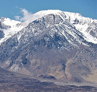
Mount Williamson, at an elevation of 14,379 feet (4,383 m), is the second-highest mountain in both the Sierra Nevada range and the state of California, and the sixth-highest peak in the contiguous United States.

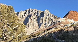
Mount Russell is a peak in the Sierra Nevada mountain range in the U.S. state of California, about 0.8 miles (1.3 km) north of Mount Whitney. Possessing an elevation of 14,094 feet (4,296 m), it is the seventh-highest peak in the state and one of California's twelve fourteeners.

Jules Marquard Eichorn was an American mountaineer, environmentalist, and music teacher.

Mount Dade is a 13,606 feet (4,147 m) mountain located on the crest of the Sierra Nevada mountain range in northern California, United States. It is situated in the John Muir Wilderness on the boundary between Sierra National Forest and Inyo National Forest, and along the common border of Fresno County with Inyo County. It is one mile west of Dade Lake, and approximately 22 miles (35 km) west of the community of Bishop. Nearby neighbors include Mount Abbot, 0.4 mile to the northwest, and Bear Creek Spire 1.2 mile to the southeast. The USGS probably named this peak during a 1907–09 survey, and the first ascent was made August 19, 1911, by Liston and McKeen, of Fresno.

Mount Gayley is a 13,510-foot-elevation mountain summit located one mile east of the crest of the Sierra Nevada mountain range in Inyo County, California, United States. It is situated in the Palisades area of the John Muir Wilderness, on land managed by Inyo National Forest. It is approximately 13 miles (21 km) west-southwest of the community of Big Pine, 0.67 miles (1.08 km) southwest of Temple Crag, and 0.5 miles (0.80 km) north-northeast of parent Mount Sill. Mount Gayley ranks as the 59th highest summit in California.

Mount Haeckel is a 13,424-foot (4,092 m) mountain summit located on the crest of the Sierra Nevada mountain range in northern California, United States. It is situated on the shared boundary of Kings Canyon National Park with John Muir Wilderness, and along the common border of Fresno County with Inyo County. It is 21.5 miles (34.6 km) west of the community of Big Pine, 1.27 miles (2.04 km) south-southeast of Mount Darwin, and one mile north-northeast of Mount Fiske, which is the nearest higher neighbor. Mount Haeckel ranks as the 71st highest summit in California.
Cloudripper is a 13,525-foot-elevation mountain summit located two miles east of the crest of the Sierra Nevada mountain range in Inyo County of northern California, United States. It is situated in the Palisades area of the John Muir Wilderness, on land managed by Inyo National Forest. It is approximately 14 miles (23 km) west of the community of Big Pine, 1.1 miles (1.8 km) north-northeast of Picture Puzzle, and 2.1 miles (3.4 km) south of parent Mount Agassiz. Cloudripper ranks as the 58th highest summit in California, and the highest point of the Inconsolable Range.

Picture Puzzle, also known as Picture Puzzle Peak, is a 13,297-foot-elevation mountain summit located one mile east of the crest of the Sierra Nevada mountain range in Inyo County of northern California, United States. It is situated in the Palisades area of the John Muir Wilderness, on land managed by Inyo National Forest. It is approximately 14.5 miles (23.3 km) west of the community of Big Pine, one mile north of Bishop Pass, 0.8 miles (1.3 km) northwest of Aperture Peak, 1.2 miles (1.9 km) north-northwest of Mount Agassiz, and 1.1 miles (1.8 km) south-southwest of parent Cloudripper. Picture Puzzle ranks as the 90th-highest summit in California, and the third-highest peak of the Inconsolable Range.

Red and White Mountain is a remote 12,816-foot-elevation mountain summit located on the crest of the Sierra Nevada mountain range in northern California, United States. It is situated in the John Muir Wilderness on the shared boundary of Sierra National Forest with Inyo National Forest, and along the common border of Fresno County with Mono County. It is eight miles northeast of Lake Thomas A Edison, and approximately 13 miles (21 km) southeast of the community of Mammoth Lakes. The nearest higher neighbor is Red Slate Mountain, 2 miles (3.2 km) to the north-northwest.

Picture Peak is a 13,140+ foot mountain summit located one mile east of the crest of the Sierra Nevada mountain range in Inyo County in northern California, United States. It is situated in the John Muir Wilderness, on land managed by Inyo National Forest. It is approximately 21 miles (34 km) west of the community of Big Pine, and 0.65 miles (1.05 km) east of parent Mount Haeckel. Topographic relief is significant as the north aspect rises over 2,000 feet above Hungry Packer Lake in approximately one-half mile (1 km). The first ascent of the summit was made July 1967, by Gary Colliver and Steve Thompson via the northeast face. This mountain's name has not been officially adopted by the U.S. Board on Geographic Names.

Seven Gables is a 13,080-foot-elevation (3,990-meter) mountain summit located in the Sierra Nevada mountain range in Fresno County of northern California, United States. It is situated between the east and south forks of Bear Creek in the John Muir Wilderness, on land managed by Sierra National Forest. It is set 9 miles (14 km) southeast of Lake Thomas A Edison, 1.2 miles (1.9 km) northwest of Gemini, and 3.2 miles (5.1 km) west-southwest of Feather Peak, the nearest higher neighbor. Topographic relief is significant as it rises nearly 3,500 feet above Upper Bear Creek Meadows in approximately two miles. Seven Gables ranks as the 133rd highest summit in California.
Goodale Mountain is a 12,772-foot-elevation (3,893-meter) mountain summit located one mile east of the crest of the Sierra Nevada mountain range, in Inyo County of northern California. It is situated less than two miles southeast of Taboose Pass in the John Muir Wilderness, on land managed by Inyo National Forest. It is also 16.5 miles (26.6 km) northwest of the community of Independence, and one mile northeast of Striped Mountain, the nearest higher neighbor. Topographic relief is significant as the east aspect rises 7,200 feet above Owens Valley in 3.5 miles. It ranks as the 218th highest peak in California.

Mount Gilbert is a 13,106-foot (3,995 m) mountain located on the crest of the Sierra Nevada range in California, United States. It is situated on the shared boundary of Kings Canyon National Park and John Muir Wilderness, and along the common border of Fresno County and Inyo County. It is 18 miles (29 km) west of the community of Big Pine, 0.8 mile northwest of Mount Johnson, and one mile southeast of Mount Thompson, which is its nearest higher neighbor. Mount Gilbert ranks as the 127th-highest summit in California. Topographic relief is significant as the south aspect rises 3,900 feet (1,189 m) above LeConte Canyon in less than two miles, and the northern aspect rises 3,340 feet above South Lake in 2.5 miles.

Mount Wallace is a 13,377-foot-elevation mountain summit located on the crest of the Sierra Nevada mountain range in northern California, United States. It is situated on the shared boundary of Kings Canyon National Park with John Muir Wilderness, and along the common border of Fresno County with Inyo County. It is 21 miles (34 km) west of the community of Big Pine, 1.38 miles (2.22 km) northwest of Mount Powell, 0.5 miles (0.80 km) southwest of Picture Peak, and 0.37 miles (0.60 km) southeast of Mount Haeckel, which is the nearest higher neighbor. Mount Wallace ranks as the 79th-highest summit in California, and the ninth-highest in the Evolution Region.

Disappointment Peak is a 13,917-foot-elevation summit located on the shared boundary of Fresno County and Inyo County in California, United States.

Mount Starr, elevation 12,835 feet (3,912 m), is a mountain summit located on the crest of the Sierra Nevada mountain range in northern California, United States. It is situated in the John Muir Wilderness on the common boundary shared by Sierra National Forest with Inyo National Forest, and along the common border of Fresno County with Inyo County. It is bound on the east by Little Lakes Valley, and is 0.8 mile northeast of Mono Pass. Topographic relief is significant as the summit rises 2,300 feet above Little Lakes Valley in approximately one-half mile (0.80 km). Neighbors include Mount Abbot, three miles to the south-southwest, Mount Morgan, 2.5 miles to the southeast, and Pointless Peak is 2.5 miles to the north.

Four Gables, elevation 12,776 feet (3,894 m), is a mountain summit located on the crest of the Sierra Nevada mountain range in northern California, United States. It is situated in the John Muir Wilderness on the common boundary shared by Sierra National Forest with Inyo National Forest, and along the common border of Fresno County with Inyo County. Topographic relief is significant as the summit rises 2,800 feet above Horton Lake in approximately 1.5 miles (2.4 km). Neighbors include Basin Mountain, two miles to the east-southeast, Mount Tom, three miles to the northeast, and Merriam Peak, four miles to the west. The nearest community is Bishop, California, 17 miles to the east.
Mount Julius Caesar is a 13,213-foot-elevation mountain summit located on the crest of the Sierra Nevada mountain range in northern California, United States. It is situated in the John Muir Wilderness on the boundary that Sierra National Forest shares with Inyo National Forest, and along the common border shared by Fresno County with Inyo County. It is one mile southwest of line parent Bear Creek Spire, and 22 miles (35 km) west of the community of Bishop. Italy Pass is one-half mile immediately south of the summit, and Granite Park lies to the southeast. Mount Julius Caesar ranks as the 106th-highest summit in California. Topographic relief is significant as the summit rises 2,000 feet above Lake Italy in 0.7 miles (1.1 km).
Mount Robinson is a 12,967-foot-elevation (3,952 meter) mountain summit located in Inyo County, California, United States.


