
The exposed geology of the Yosemite area includes primarily granitic rocks with some older metamorphic rock. The first rocks were laid down in Precambrian times, when the area around Yosemite National Park was on the edge of a very young North American continent. The sediment that formed the area first settled in the waters of a shallow sea, and compressive forces from a subduction zone in the mid-Paleozoic fused the seabed rocks and sediments, appending them to the continent. Heat generated from the subduction created island arcs of volcanoes that were also thrust into the area of the park. In time, the igneous and sedimentary rocks of the area were later heavily metamorphosed.

Cathedral Peak is part of the Cathedral Range, a mountain range in the south-central portion of Yosemite National Park in eastern Mariposa and Tuolumne Counties. The range is an offshoot of the Sierra Nevada. The peak which lends its name to the range derives its name from its cathedral-shaped peak, which was formed by glacial activity: the peak remained uneroded above the glaciers in the Pleistocene.

The Santa Lucia Mountains or Santa Lucia Range is a rugged mountain range in coastal central California, running from Carmel southeast for 140 miles (230 km) to the Cuyama River in San Luis Obispo County. The range is never more than 11 miles (18 km) from the coast. The range forms the steepest coastal slope in the contiguous United States. Cone Peak at 5,158 feet (1,572 m) tall and three miles (5 km) from the coast, is the highest peak in proximity to the ocean in the lower 48 United States. The range was a barrier to exploring the coast of central California for early Spanish explorers.

Granodiorite is a coarse-grained (phaneritic) intrusive igneous rock similar to granite, but containing more plagioclase feldspar than orthoclase feldspar.

The Gascoyne Complex is a terrane of Proterozoic granite and metamorphic rock in the central-western part of Western Australia. The complex outcrops at the exposed western end of the Capricorn Orogen, a 1,000 km-long arcuate belt of folded, faulted and metamorphosed rocks between two Archean cratons; the Pilbara craton to the north and the Yilgarn craton to the south. The Gascoyne Complex is thought to record the collision of these two different Archean continental fragments during the Capricorn Orogeny at 1830–1780 Ma.

The Sierra Nevada Batholith is a large batholith that is approximately 400 miles long and 60-80 miles wide which forms the core of the Sierra Nevada mountain range in California, exposed at the surface as granite.

Granite Mountain is a 7,628-foot (2,325 m) mountain located in Yavapai County, Arizona that covers roughly 12 square miles (31 km2). It was once known as Mount Gurley, for the first governor of the Arizona Territory, John A. Gurley. Its southwest face has a sheer granite cliff approximately 500 feet high that is one of the best locations for rock climbing in the state of Arizona. It is located in the Granite Mountain Wilderness, which is managed as a part of the Prescott National Forest. The mountain stands at the northern end of the Sierra Prietas, and borders Skull Valley on the west, on the northwest by the Santa Maria Mountains, and east by the Williamson Valley.
The Kern Canyon Fault is a dextral strike-slip fault (horizontal) that runs roughly around 150 km (93 mi) beside the Kern River Canyon through the mountainous area of the Southern Sierra Nevada Batholith. The fault was a reverse fault in the Early Cretaceous epoch during the primal stages of the Farallon Plate subduction beneath the North American Continental Plate and fully transitioned into a strike-slip shear zone during the Late Cretaceous.

In structural geology, a roof pendant, also known as a pendant, is a mass of country rock that projects downward into and is entirely surrounded by an igneous intrusion such as a batholith or other pluton. In lay terminology sometimes "rock hat" is used. A roof pendant is an erosional remnant that was created by the removal of the overlying country rock that formed the roof of the igneous intrusion that encloses it. If this downward protruding mass of roof rock still has a connection to the main, surrounding mass of country rock, they are known by structural geologists as either septa or screens. Roof pendants typically have been strongly metamorphosed through the processes of contact metamorphism.

The Cathedral Peak Granodiorite (CPG) was named after its type locality, Cathedral Peak in Yosemite National Park, California. The granodiorite forms part of the Tuolumne Intrusive Suite, one of the four major intrusive suites within the Sierra Nevada. It has been assigned radiometric ages between 88 and 87 million years and therefore reached its cooling stage in the Coniacian.

The Idaho Batholith is a granitic and granodioritic batholith of Cretaceous-Paleogene age that covers approximately 25,000 square kilometres (9,700 sq mi) of central Idaho and adjacent Montana. The batholith has two lobes that are separate from each other geographically and geologically. The Bitterroot lobe is the smaller lobe and the larger lobe is the Atlanta lobe. The Bitterroot lobe is in the north and is separated from the larger Atlanta lobe in the south by the Belt Supergroup metamorphic rocks that compose the Salmon River Arch. Much of the Atlanta and Bitterroot lobes are in the Idaho Batholith ecoregion.
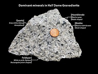
Half Dome Granodiorite is granodiorite found in a region on and near Half Dome, in Yosemite National Park, California, United States. The granodiorite forms part of the Tuolumne Intrusive Suite, one of the four major intrusive suites within the Sierra Nevada.

El Capitan Granite is a type of granite, in a large area near El Capitan, in Yosemite National Park, California, United States. The granite forms part of the Tuolumne Intrusive Suite, one of the four major intrusive suites within the Sierra Nevada.
Kuna Crest Granodiorite, is found, in Yosemite National Park, United States. The granodiorite forms part of the Tuolumne Intrusive Suite, one of the four major intrusive suites within the Sierra Nevada. Of the Tuolumne Intrusive Suite, it is the oldest and darkest rock.

Sentinel granodiorite is a type of granodiorite found in Yosemite National Park. It is a poorly understood western "outlier" of the ~93-85-Ma Tuolumne Intrusive Suite of the Sierra Nevada batholith. It is only slightly older than the undated Yosemite Creek Granodiorite and the Kuna Crest Granodiorite.
The Tuolumne Intrusive Suite is the youngest and most extensive of the intrusive suites of Yosemite National Park, and also comprises about 1/3 of the park's area. The Suite includes Half Dome Granodiorite, Cathedral Peak Granite, and Kuna Crest Granodiorite.
The Achala Batholith is a group of plutons in the Sierras de Córdoba in central Argentina. With a mapped surface of over 2,500 square kilometres (970 sq mi) it constitutes the largest group of intrusions exposed in the Sierras Pampeanas. The oldest reference to the batholith dates to 1932.
The Intrusive Suite of Sonora Pass is one of several intrusive suites in Yosemite National Park. These also include
- Fine Gold Intrusive Suite
- Intrusive Suite of Buena Vista Crest
- Intrusive Suite of Jack Main Canyon
- Intrusive Suite of Merced Peak
- Intrusive Suite of Yosemite Valley
- Tuolumne Intrusive Suite

The geology of California is highly complex, with numerous mountain ranges, substantial faulting and tectonic activity, rich natural resources and a history of both ancient and comparatively recent intense geological activity. The area formed as a series of small island arcs, deep-ocean sediments and mafic oceanic crust accreted to the western edge of North America, producing a series of deep basins and high mountain ranges.
Johnson Granite Porphyry is found in Tuolumne Meadows, Yosemite National Park.


