The Sacramento River is the principal river of Northern California in the United States and is the largest river in California. Rising in the Klamath Mountains, the river flows south for 400 miles (640 km) before reaching the Sacramento–San Joaquin River Delta and San Francisco Bay. The river drains about 26,500 square miles (69,000 km2) in 19 California counties, mostly within the fertile agricultural region bounded by the Coast Ranges and Sierra Nevada known as the Sacramento Valley, but also extending as far as the volcanic plateaus of Northeastern California. Historically, its watershed has reached as far north as south-central Oregon where the now, primarily, endorheic (closed) Goose Lake rarely experiences southerly outflow into the Pit River, the most northerly tributary of the Sacramento.

The Kings River is a 132.9-mile (213.9 km) river draining the Sierra Nevada mountain range in central California in the United States. Its headwaters originate along the Sierra Crest in and around Kings Canyon National Park and form the eponymous Kings Canyon, one of the deepest river gorges in North America. The river is impounded in Pine Flat Lake before flowing into the San Joaquin Valley southeast of Fresno. With its upper and middle course in Fresno County, the Kings River diverges into multiple branches in Kings County, with some water flowing south to the old Tulare Lake bed and the rest flowing north to the San Joaquin River. However, most of the water is consumed for irrigation well upstream of either point.

The Tuolumne River flows for 149 miles (240 km) through Central California, from the high Sierra Nevada to join the San Joaquin River in the Central Valley. Originating at over 8,000 feet (2,400 m) above sea level in Yosemite National Park, the Tuolumne drains a rugged watershed of 1,958 square miles (5,070 km2), carving a series of canyons through the western slope of the Sierra. While the upper Tuolumne is a fast-flowing mountain stream, the lower river crosses a broad, fertile and extensively cultivated alluvial plain. Like most other central California rivers, the Tuolumne is dammed multiple times for irrigation and the generation of hydroelectricity.

The Walker River is a river in west-central Nevada in the United States, approximately 62 miles (100 km) long. Fed principally by snowmelt from the Sierra Nevada of California, it drains an arid portion of the Great Basin southeast of Reno and flows into the endorheic basin of Walker Lake. The river is an important source of water for irrigation in its course through Nevada; water diversions have reduced its flow such that the level of Walker Lake has fallen 160 feet (49 m) between 1882 and 2010. The river was named for explorer Joseph Reddeford Walker, a mountain man and experienced scout who is known for establishing a segment of the California Trail.

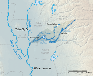
The Feather River is the principal tributary of the Sacramento River, in the Sacramento Valley of Northern California. The river's main stem is about 73 miles (117 km) long. Its length to its most distant headwater tributary is just over 210 miles (340 km). The main stem Feather River begins in Lake Oroville, where its four long tributary forks join—the South Fork, Middle Fork, North Fork, and West Branch Feather Rivers. These and other tributaries drain part of the northern Sierra Nevada, and the extreme southern Cascades, as well as a small portion of the Sacramento Valley. The total drainage basin is about 6,200 square miles (16,000 km2), with approximately 3,604 square miles (9,330 km2) above Lake Oroville.

New Bullards Bar Dam is a variable radius concrete arch dam constructed in the early 1960s in California on the North Yuba River. Located near the town of Dobbins in Yuba County, the dam forms the New Bullards Bar Reservoir, which can hold about 969,600 acre⋅ft (1,196,000 dam3) of water. The dam serves for irrigation, drinking water and hydroelectric power generation.

Pine Flat Dam is a concrete gravity dam on the Kings River in the Central Valley of Fresno County, California United States. Situated about 28 miles (45 km) east of Fresno, the dam is 440 feet (130 m) high and impounds Pine Flat Lake, one of the largest reservoirs in California, in the foothills of the Sierra Nevada just outside the boundary of Kings Canyon National Park. The dam's primary purpose is flood control, with irrigation, hydroelectric power generation and recreation secondary in importance.

The Stanislaus River is a tributary of the San Joaquin River in north-central California in the United States. The main stem of the river is 96 miles (154 km) long, and measured to its furthest headwaters it is about 150 miles (240 km) long. Originating as three forks in the high Sierra Nevada, the river flows generally southwest through the agricultural San Joaquin Valley to join the San Joaquin south of Manteca, draining parts of five California counties. The Stanislaus is known for its swift rapids and scenic canyons in the upper reaches, and is heavily used for irrigation, hydroelectricity and domestic water supply.

The Yuba River is a tributary of the Feather River in the Sierra Nevada and eastern Sacramento Valley, in the U.S. state of California. The main stem of the river is about 40 miles (64 km) long, and its headwaters are split into three major forks. The Yuba River proper is formed at the North Yuba and Middle Yuba rivers' confluence, with the South Yuba joining a short distance downstream. Measured to the head of the North Yuba River, the Yuba River is just over 100 miles (160 km) long.
Nevada Irrigation District (NID) is an agency in Northern California that supplies water for much of Nevada County and portions of Placer and Yuba Counties. The water is used for irrigation, municipal and domestic purposes. It was established in 1921.
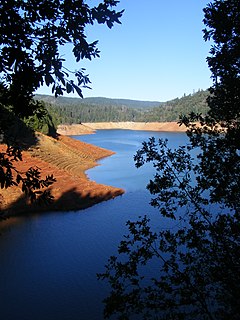
New Bullards Bar Reservoir is a large reservoir in northeastern Yuba County, California, United States, at an elevation of 2,000 feet (610 m) in the Tahoe National Forest and about 30 miles (50 km) northeast of Yuba City. The 969,600 acre-foot (1.1960×10⁹ m3) reservoir is formed by New Bullards Bar Dam on the North Yuba River, a tributary of the Yuba River. It also receives a portion of the Middle Fork's flow that is diverted to the reservoir via tunnels.
Englebright Dam is a 280 ft (85 m) high variable radius concrete arch dam on the Yuba River in the Sacramento River Basin, located in Yuba and Nevada Counties of California, USA. It was put into service in 1941 by the United States Army Corps of Engineers.

The Middle Yuba River is one of the three main forks of the Yuba River in Northern California in the United States. The river rises at the crest of the Sierra Nevada, and flows generally west through canyons to join the North Yuba River near North San Juan. The confluence of the two rivers forms the main stem of the Yuba River, which then continues west to join the Feather River. The Middle Yuba forms much of the border between Nevada County and Sierra County and in its lower reaches a small segment of the Nevada–Yuba County line. The Middle Yuba drains a remote, rugged portion of the Tahoe National Forest, with elevations ranging from 8,373 ft (2,552 m) at English Mountain to 1,129 ft (344 m) at the confluence with the Yuba River.

New Don Pedro Dam, often known simply as Don Pedro Dam, is an earthen embankment dam across the Tuolumne River, about 2 miles (3.2 km) northeast of La Grange, in Tuolumne County, California. The dam was completed in 1971, after four years of construction, to replace the 1924 concrete-arch Don Pedro Dam.

Camanche Dam is an earthfill Dam on the Mokelumne River in the central California, about 20 mi (32 km) from East Lodi. The dam and reservoir lie in the Sierra Nevada foothills in San Joaquin County. Construction of Camanche Dam was started in 1963 and completed in 1964. East Bay Municipal Utilities District (EBMUD) owns and operates it. The purpose of Camanche Dam and reservoir is to provide flood control, water flows for agriculture, habitat for fisheries and recreation for community.

Rollins Dam is a dam on the border of Nevada and Placer counties in northern California, in the United States.

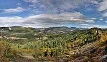
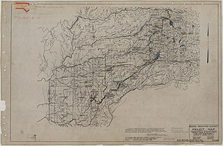
The Yuba–Bear Hydroelectric Project is a complex hydroelectric scheme in the northern Sierra Nevada in California, tapping the upper Yuba River and Bear River drainage basins. The project area encompasses approximately 400 square miles (1,000 km2) in Nevada, Placer, and Sierra Counties. Owned by the Nevada Irrigation District, it consists of 16 storage dams plus numerous diversion and regulating dams, and four generating stations producing 425 million kilowatt hours of electricity each year. The Yuba–Bear Hydroelectric Project consists of the Bowman development, Dutch Flat No. 2 development, Chicago Park development, and Rollins development.

The Upper North Fork Feather River Project is a hydroelectric scheme in the Sierra Nevada of California, within Lassen and Plumas Counties. The project consists of three dams, five power plants, and multiple conduits and tunnels in the headwaters of the North Fork Feather River, a major tributary of the Feather—Sacramento River systems. The total installed capacity is 362.3 megawatts (MW), producing an annual average of 1,171.9 gigawatt hours (GWh). The project is also contracted for the delivery of irrigation water between March 31 and October 31 of each year. The project is owned and operated by Pacific Gas and Electric Company.
Centennial Dam is a proposed dam on the border of Placer County and Nevada County in Northern California near Colfax. The contingent reservoir would be created by a 275-foot dam along the Bear River between two existing reservoirs — Lake Combie and Rollins Reservoir — and would hold 110,000 acre feet of water.
Canyon Creek is a major tributary of the South Yuba River in the Sierra Nevada mountain range.