
The Kings River, is a 132.9-mile (213.9 km) river draining the Sierra Nevada mountain range in central California in the United States. Its headwaters originate along the Sierra Crest in and around Kings Canyon National Park and form the eponymous Kings Canyon, one of the deepest river gorges in North America. The river is impounded in Pine Flat Lake before flowing into the San Joaquin Valley southeast of Fresno. With its upper and middle course in Fresno County, the Kings River diverges into multiple branches in Kings County, with some water flowing south to the old Tulare Lake bed and the rest flowing north to the San Joaquin River. However, most of the water is consumed for irrigation well upstream of either point.

The Tuolumne River flows for 149 miles (240 km) through Central California, from the high Sierra Nevada to join the San Joaquin River in the Central Valley. Originating at over 8,000 feet (2,400 m) above sea level in Yosemite National Park, the Tuolumne drains a rugged watershed of 1,958 square miles (5,070 km2), carving a series of canyons through the western slope of the Sierra. While the upper Tuolumne is a fast-flowing mountain stream, the lower river crosses a broad, fertile and extensively cultivated alluvial plain. Like most other central California rivers, the Tuolumne is dammed multiple times for irrigation and the generation of hydroelectricity.

The Kern River is an Endangered, Wild and Scenic river in the U.S. state of California, approximately 165 miles (270 km) long. It drains an area of the southern Sierra Nevada mountains northeast of Bakersfield. Fed by snowmelt near Mount Whitney, the river passes through scenic canyons in the mountains and is a popular destination for whitewater rafting and kayaking. It is the southernmost major river system in the Sierra Nevada, and is the only major river in the Sierra that drains in a southerly direction.

The Kaweah River is a river draining the southern Sierra Nevada in Tulare County, California in the United States. Fed primarily by high elevation snowmelt along the Great Western Divide, the Kaweah begins as four forks in Sequoia National Park, where the watershed is noted for its alpine scenery and its dense concentrations of giant sequoias, the largest trees on Earth. It then flows in a southwest direction to Lake Kaweah – the only major reservoir on the river – and into the San Joaquin Valley, where it diverges into multiple channels across an alluvial plain around Visalia. With its Middle Fork headwaters starting at almost 13,000 feet (4,000 m) above sea level, the river has a vertical drop of nearly two and a half miles (4.0 km) on its short run to the San Joaquin Valley, making it one of the steepest river drainages in the United States. Although the main stem of the Kaweah is only 33.6 miles (54.1 km) long, its total length including headwaters and lower branches is nearly 100 miles (160 km).
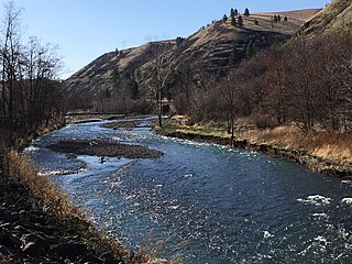
The Touchet River is a 65-mile (105 km) tributary of the Walla Walla River in southeastern Washington in the United States. The Touchet River drains an area of about 752 square miles (1,950 km2) in Columbia County and Walla Walla County.

Stony Creek is a 73.5-mile (118.3 km)-long tributary of the Sacramento River in Northern California. It drains a watershed of more than 700 square miles (1,800 km2) on the west side of the Sacramento Valley in Glenn, Colusa, Lake and Tehama Counties.

The Middle Fork Kings River is a 37.2-mile (59.9 km) tributary of the Kings River in Kings Canyon National Park, California, in the southern Sierra Nevada. Draining 318 square miles (820 km2) – almost all of it wilderness – the Middle Fork is one of the largest wholly undeveloped watersheds in the state, with no dams or paved roads within its basin. The entire length of the Middle Fork is designated a National Wild and Scenic River.

The South Fork Kings River is a 44.1-mile (71.0 km) tributary of the Kings River in the Sierra Nevada of Fresno County, California. The river forms part of Kings Canyon, the namesake of Kings Canyon National Park and one of the deepest canyons in North America with a maximum relief of 8,200 feet (2,500 m) from rim to river.
The Little Kern River is a 24.4-mile-long (39.3 km) major tributary of the upper Kern River in the Sequoia National Forest, in the southern Sierra Nevada, California. It is one of three streams, along with Volcano Creek and Golden Trout Creek, that harbor beautiful golden trout.

The Middle Fork American River is one of three forks that form the American River in Northern California. It drains a large watershed in the high Sierra Nevada west of Lake Tahoe and northeast of Sacramento in Placer and El Dorado Counties, between the watersheds of the North Fork American River and South Fork American River. The Middle Fork joins with the North Fork near Auburn and they continue downstream to Folsom Lake as the North Fork, even though the Middle Fork carries a larger volume of water.

The North Fork Stanislaus River is a 31.2-mile (50.2 km) tributary of the Stanislaus River in the central Sierra Nevada and Stanislaus National Forest of eastern California.

The Middle Fork Stanislaus River is a 45.7-mile (73.5 km) tributary of the Stanislaus River in the central Sierra Nevada and Stanislaus National Forest of eastern California.

Deep Creek is a tributary of the Mojave River, 23.4 miles (37.7 km) long, in San Bernardino County, California.

The South Fork Stanislaus River is a major tributary of the Stanislaus River in Tuolumne County, California. The river flows for 48.5 miles (78.1 km) through rugged alpine and foothill areas of the Sierra Nevada.

Cottonwood Creek is a major stream, about 36 miles (58 km) long, in southern San Diego County, California. It is part of the Tijuana River drainage basin.

The North Fork Tuolumne River is a 35.7-mile (57.5 km) long river in the central Sierra Nevada of Tuolumne County, California and is a major tributary of the Tuolumne River. It originates above the Dodge Ridge Ski Area about 2 miles (3.2 km) east of Pinecrest, in the Stanislaus National Forest. From there it flows generally southwest, past Long Barn, Twaine Harte, Soulsbyville and Tuolumne. Below Long Barn the river flows through a narrow canyon on its way to join the Tuolumne River, at the head of Lake Don Pedro Reservoir, about 5 miles (8.0 km) north of Groveland.
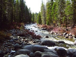
Dinkey Creek is a large stream in the southern Sierra Nevada, in Fresno County, California. The creek is 29.2 miles (47.0 km) long, flowing undammed in a southerly direction through the Sierra National Forest. It is a tributary of the North Fork Kings River, in turn part of the Kings River system which drains into the de-watered Tulare Lake bed.

Arroyo Grande Creek is a major stream in San Luis Obispo County on the Central Coast of California. The creek flows 22 miles (35 km) in a southwesterly direction, from the Santa Lucia Range to the Pacific Ocean. It is a major source of water supply for southern San Luis Obispo County.

Rio San Antonio is a tributary of the Conejos River in northern New Mexico and southern Colorado. Via the Conejos River, it is part of the upper Rio Grande system. The river is used extensively for irrigation in its lower course through the southern San Luis Valley.

Mill Creek is a 36.5-mile (58.7 km) long tributary of the Walla Walla River, flowing through southeast Washington and northeast Oregon in the United States. It drains from the western side of the Blue Mountains into the Walla Walla Valley and flows through the city of Walla Walla, which draws most of its water supply from the creek. The creek is named for the sawmill built in 1845 by Marcus Whitman, one of the first European settlers in the valley.

