Mariposa Creek

Last updated
Mariposa Creek
Mariposa River [1]
Mariposa Creek.jpg
Mariposa Creek in the town of Mariposa
Location
Country United States
State California
Region Merced County
Cities Mariposa, Le Grand
Physical characteristics
Source 
  locationWestern Sierra Nevada foothills
  coordinates 37°32′10″N120°00′40″W / 37.53611°N 120.01111°W / 37.53611; -120.01111 [2]
  elevation3,092 ft (942 m)
Mouth  
  location
Duck Slough
  coordinates
37°14′55″N120°18′34″W / 37.24861°N 120.30944°W / 37.24861; -120.30944 [2]
  elevation
0 ft (0 m) [2]
Basin features
Tributaries 
  left Stockton Creek, Spring Creek, Brushy Canyon Creek, Ganns Creek
  rightAgua Fria Creek, China Gulch, Bull Run Creek

Mariposa Creek, originally called the Mariposa River, [1] is a creek that has its source in Mariposa County, California. It flows through the town of Mariposa then southwest through the Sierra foothills, into and across the San Joaquin Valley in Merced County, and empties the sloughs of the San Joaquin River south of the city of Merced.

Contents

History

Mariposa Creek was named by the Spanish explorer Gabriel Moraga on September 27, 1806, when his expedition discovered a great cluster of butterflies ("mariposas" in Spanish and Portuguese):

"We named this place Mariposas [butterflies] because these abounded, especially at night and during the morning. These butterflies became quite a nuisance. Their eagerness to escape the sun's rays was so pronounced that they pursued us closely everywhere and one of them got inside the ear of one of the privates, causing him great discomfort and us much trouble in extracting it." [3] [4]

Each year on the first weekend in May, Mariposa residents mark the annual arrival of migrating monarch butterflies with a "Butterfly Days" festival and parade.

During the California Gold Rush, the Mariposa River was a rich gold-bearing creek and the site of several mining camps, including Logtown, Mariposa and Mariposita.

Watershed

Mariposa County contains three major drainage basins: the Merced River, Chowchilla River/Fresno River, and a localized cluster of streams of the east valley known as the Lower Mariposa group of streams. These three basins and their component watersheds are part of the much larger San Joaquin River system that drains the western slopes of the Sierra Nevada. At the lower end of the watershed, Mariposa Creek is dammed by the Mariposa Creek Dam (88 feet (27 m) high). The Mariposa Public Utilities District (MPUD) operates the Stockton Creek Dam (95 feet (29 m) tall) on Stockton Creek, a tributary of Mariposa Creek. [5]

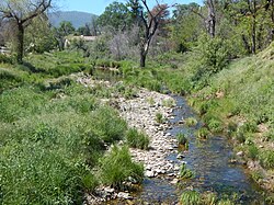
Mariposa Creek Parkway

Mariposa County maintains a park along the creek in downtown Mariposa. It features an Art Park with an amphitheatre, and a demonstration garden of California native plants sponsored by the local chapter of the Master Gardeners.

Images

Related Research Articles

<span class="mw-page-title-main">Mariposa County, California</span> County in California, United States

Mariposa County is a county located in the U.S. state of California. As of the 2020 U.S. Census, the population was 17,131. The county seat is Mariposa. It is located in the western foothills of the Sierra Nevada mountains, north of Fresno, east of Merced, and southeast of Stockton.

<span class="mw-page-title-main">San Joaquin River</span> Longest river of Central California, United States

The San Joaquin River is the longest river of Central California. The 366-mile (589 km) long river starts in the high Sierra Nevada, and flows through the rich agricultural region of the northern San Joaquin Valley before reaching Suisun Bay, San Francisco Bay, and the Pacific Ocean. An important source of irrigation water as well as a wildlife corridor, the San Joaquin is among the most heavily dammed and diverted of California's rivers.

<span class="mw-page-title-main">Kings River (California)</span> River in central California, US

The Kings River, is a 132.9-mile (213.9 km) river draining the Sierra Nevada mountain range in central California in the United States. Its headwaters originate along the Sierra Crest in and around Kings Canyon National Park and form the eponymous Kings Canyon, one of the deepest river gorges in North America. The river is impounded in Pine Flat Lake before flowing into the San Joaquin Valley southeast of Fresno. With its upper and middle course in Fresno County, the Kings River diverges into multiple branches in Kings County, with some water flowing south to the old Tulare Lake bed and the rest flowing north to the San Joaquin River. However, most of the water is consumed for irrigation well upstream of either point.

<span class="mw-page-title-main">Merced River</span> River in California

The Merced River, in the central part of the U.S. state of California, is a 145-mile (233 km)-long tributary of the San Joaquin River flowing from the Sierra Nevada into the San Joaquin Valley. It is most well known for its swift and steep course through the southern part of Yosemite National Park, where it is the primary watercourse flowing through Yosemite Valley. The river's character changes dramatically once it reaches the plains of the agricultural San Joaquin Valley, where it becomes a slow-moving meandering stream.

<span class="mw-page-title-main">Tuolumne River</span> River from Yosemite to the San Joaquin Valley, California

The Tuolumne River flows for 149 miles (240 km) through Central California, from the high Sierra Nevada to join the San Joaquin River in the Central Valley. Originating at over 8,000 feet (2,400 m) above sea level in Yosemite National Park, the Tuolumne drains a rugged watershed of 1,958 square miles (5,070 km2), carving a series of canyons through the western slope of the Sierra. While the upper Tuolumne is a fast-flowing mountain stream, the lower river crosses a broad, fertile and extensively cultivated alluvial plain. Like most other central California rivers, the Tuolumne is dammed multiple times for irrigation and the generation of hydroelectricity.

Gabriel Moraga was a Sonoran-born Californio explorer and army officer. He was the son of the expeditionary José Joaquín Moraga who helped to lead the de Anza Expedition to California in 1774, Like his father, Moraga is one of the most notable Spanish expeditionaries in the history of Alta California and the origin of the names of many of the most notable rivers and cities of Northern California and the Central Valley.

<span class="mw-page-title-main">Central California</span> Region of California in the United States

Central California is generally thought of as the middle third of the U.S. state, of California, north of Southern California, which includes Los Angeles, and south of Northern California, which includes San Francisco. It includes the northern portion of the San Joaquin Valley, part of the Central Coast, the central hills of the California Coast Ranges and the foothills and mountain areas of the central Sierra Nevada.

<span class="mw-page-title-main">Mokelumne River</span> River in northern California

The Mokelumne River is a 95-mile (153 km)-long river in northern California in the United States. The river flows west from a rugged portion of the central Sierra Nevada into the Central Valley and ultimately the Sacramento–San Joaquin River Delta, where it empties into the San Joaquin River-Stockton Deepwater Shipping Channel. Together with its main tributary, the Cosumnes River, the Mokelumne drains 2,143 square miles (5,550 km2) in parts of five California counties. Measured to its farthest source at the head of the North Fork, the river stretches for 157 miles (253 km).

<span class="mw-page-title-main">Stanislaus River</span> River in north-central California, US

The Stanislaus River is a tributary of the San Joaquin River in north-central California in the United States. The main stem of the river is 96 miles (154 km) long, and measured to its furthest headwaters it is about 150 miles (240 km) long. Originating as three forks in the high Sierra Nevada, the river flows generally southwest through the agricultural San Joaquin Valley to join the San Joaquin south of Manteca, draining parts of five California counties. The Stanislaus is known for its swift rapids and scenic canyons in the upper reaches, and is heavily used for irrigation, hydroelectricity and domestic water supply.

<span class="mw-page-title-main">Tule River</span> River in California, United States

The Tule River, also called Rio de San Pedro or Rio San Pedro, is a 71.4-mile (114.9 km) river in Tulare County in the U.S. state of California. The river originates in the Sierra Nevada east of Porterville and consists of three forks, North, Middle and South. The North Fork and Middle Fork meet above Springville. The South Fork meets the others at Lake Success. Downstream of Success Dam, the river flows west through Porterville. The river used to empty into Tulare Lake, but its waters have been diverted for irrigation. However, the river does reach Tulare Lake during floods. Tulare Lake is the terminal sink of an endorheic basin that historically also received the Kaweah and Kern Rivers as well as southern distributaries of the Kings.

<span class="mw-page-title-main">Area codes 209 and 350</span> Area codes in northern Central Valley, California

Area codes 209 and 350 are telephone area codes in the North American Numbering Plan (NANP) for the U.S. state of California. Their service area includes Stockton, Modesto, Turlock, Merced, Winton, Atwater, Livingston, Manteca, Ripon, Tracy, Lodi, Galt, Sonora, Los Banos, San Andreas, Mariposa, and Yosemite, the northern San Joaquin Valley, and the Sierra Foothills.

<span class="mw-page-title-main">Kaweah River</span> River in the United States of America

The Kaweah River is a river draining the southern Sierra Nevada in Tulare County, California in the United States. Fed primarily by high elevation snowmelt along the Great Western Divide, the Kaweah begins as four forks in Sequoia National Park, where the watershed is noted for its alpine scenery and its dense concentrations of giant sequoias, the largest trees on Earth. It then flows in a southwest direction to Lake Kaweah – the only major reservoir on the river – and into the San Joaquin Valley, where it diverges into multiple channels across an alluvial plain around Visalia. With its Middle Fork headwaters starting at almost 13,000 feet (4,000 m) above sea level, the river has a vertical drop of nearly two and a half miles (4.0 km) on its short run to the San Joaquin Valley, making it one of the steepest river drainages in the United States. Although the main stem of the Kaweah is only 33.6 miles (54.1 km) long, its total length including headwaters and lower branches is nearly 100 miles (160 km).

<span class="mw-page-title-main">Calaveras River</span> River in California, United States

The Calaveras River is a river in the San Joaquin Valley of California.

The Chowchilla River is a river in central California, United States and a minor tributary of the San Joaquin River. It flows for 54.2 miles (87.2 km) from the western side of the Sierra Nevada Range to the San Joaquin River system in the San Joaquin Valley.

<span class="mw-page-title-main">Plains and Sierra Miwok</span> Largest group of California Indian Miwok people

The Plains and Sierra Miwok were once the largest group of California Indian Miwok people, Indigenous to California. Their homeland included regions of the Sacramento Valley, San Joaquin Valley, and the Sierra Nevada.

<span class="mw-page-title-main">Yosemite Creek</span> River

Yosemite Creek is a 15-mile-long (24 km) creek of the Sierra Nevada, located in Yosemite National Park, Mariposa County, California, United States.

<span class="mw-page-title-main">Beavers in the Sierra Nevada</span> Wildlife indigenous to California mountains

The North American beaver had a historic range that overlapped the Sierra Nevada in California. Before the European colonization of the Americas, beaver were distributed from the arctic tundra to the deserts of northern Mexico. The California Golden beaver subspecies was prevalent in the Sacramento and San Joaquin River watersheds, including their tributaries in the Sierra Nevada. Recent evidence indicates that beaver were native to the High Sierra until their extirpation in the nineteenth century.

There are 45 routes assigned to the "J" zone of the California Route Marker Program, which designates county routes in California. The "J" zone includes county highways in Alameda, Calaveras, Contra Costa, Fresno, Kern, Inyo, Mariposa, Merced, Sacramento, San Benito, San Joaquin, Stanislaus, and Tulare counties.

The Stockton–Los Angeles Road, also known as the Millerton Road, Stockton–Mariposa Road, Stockton–Fort Miller Road or the Stockton–Visalia Road, was established about 1853 following the discovery of gold on the Kern River in Old Tulare County. This route between Stockton and Los Angeles followed by the Stockton–Los Angeles Road is described in "Itinerary XXI. From Fort Yuma to Benicia, California", in The Prairie Traveler: A Hand-book for Overland Expeditions by Randolph Barnes Marcy. The Itinerary was derived from the report of Lieutenant R. S. Williamson on his topographical survey party in 1853, that was in search of a railroad route through the interior of California.

<span class="mw-page-title-main">Stockton Creek</span> River

Stockton Creek is a tributary of Mariposa Creek in Mariposa County, California. It was named after Robert F. Stockton who owned a mine and stamp mill during the California Gold Rush. An impoundment on the creek owned by the Mariposa Public Utilities Commission holds a major source of water for the community of Mariposa.

References

  1. 1 2 Nellie Van de Grift Sanchez (1914). Spanish and Indian Place Names of California: Their Meaning and Their Romance. California: A. M. Robertson. p.  291 . Retrieved May 31, 2016.
  2. 1 2 3 "Mariposa Creek". Geographic Names Information System . United States Geological Survey, United States Department of the Interior.
  3. Pedro Muñoz; Robert Glass Cleland; Haydée Noya (May 1946). "The Gabriel Moraga Expedition of 1806: The Diary of Fray Pedro Muñoz". Huntington Library Quarterly. 9 (3). University of Pennsylvania Press: 223–248. doi:10.2307/3816007. JSTOR   3816007.
  4. Phil Townsend Hanna (1946). The Dictionary of California Land Names. Los Angeles: The Automobile Club of Southern California. p. 167.
  5. County of Mariposa General Plan – Volume III. Technical Background Report (Report). Retrieved May 31, 2016.