According to the United States Census Bureau, the city has a total area of 3.6 square miles (9.3km2), all of it land.[6]Jackson Creek traverses the city. Alluvial soils such as Pardee cobbly loam is found throughout the Jackson area.
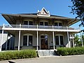
The Amador County Courthouse consists of two buildings, the second courthouse (built 1864) and the Hall of Records (1893), that were enclosed and combined in 1939 with an Art Deco exterior. It was recently closed and legal activities have resumed in another, newer facility.
Early history
The area was inhabited by the Northern Sierra Indians, who occupied areas along creeks, spring, and seep areas, including permanent and seasonal drainages, flat ridges, and terraces. Therefore, areas along watercourses are considered likely locations for prehistoric cultural resources. Permanent villages were usually placed on elevations above seasonal flood levels. Surrounding areas were used for hunting and seed, acorn, and grass gathering.
19th century and later
Jackson, named after Colonel Alden Jackson, was founded in 1848 around a year-round spring. Settlement of the region by American pioneers was stimulated by the discovery of gold in the Sierra foothills around 1848. The settlement was named for a local lawyer who was liked by miners named Alden Appola Moore Jackson. Although Amador County was an important mining center, its county seat of Jackson was not typical of the early gold camps. The camp grew quickly, as besides being a popular mining spot, it was also a convenient stopping place on the road from Sacramento to the Southern Mines. The camp became an important supply and transportation center for the neighboring towns, and by 1850, its population had reached an estimated 1,500. Jackson grew first as a watering hole for cattle, then as one of the earliest and most durable of the mother lode's hard rock mining areas. In 1854, Jackson became the county seat of newly formed Amador County, California. Previously, from 1851 to 1852, it had been the county seat of Calaveras County.
Placer mining gave out by the 1860s, replaced by hard rock mining. One of the town's most prominent historical landmarks, the Kennedy Mine, began operation in 1860; at the time of its closure during World War II in 1942, it was the deepest gold mine in North America, at 1802m (5912ft). On August 27, 1922, 47 miners became trapped when a fire broke out in the Argonaut mine. All 47 men died in the fire, but the last body was not recovered until over a year later. The Argonaut mine incident was the worst gold mine disaster in US history.
In October 1942, the US government passed the War Production Board Limitation Order, which signaled the demise of gold mining in California. The government needed men for the war and gold was not considered a strategic war metal.
Jackson Gate: Jackson Gate, on the north fork of Jackson Creek, takes its name from a fissure in a reef of rock that crosses the creek. In 1850, about 500 miners worked here and the first mining ditch in the county was dug here; its water sold for $1 per inch, CHL No. 118.[14]
Site of Jackson's Pioneer JewishSynagogue: On September 18, 1857, Congregation B'nai Israel of Jackson dedicated on this site the first synagogue in the Mother Lode. High holy day worship continued until 1869 when the larger Masonic Hall was used to accommodate the congregation. The wooden structure then served as a schoolhouse until 1888. Relocated onto a nearby lot, it became a private dwelling, and was razed in 1948, CHL No. 865.[15] The Jackson Pioneer Jewish Cemetery (active from 1857 to 1921) was connected to the synagogue.
The Census reported that 96.6% of the population lived in households, 1.0% lived in non-institutionalized group quarters, and 2.4% were institutionalized.[19]
There were 2,185 households, out of which 24.7% included children under the age of 18, 39.5% were married-couple households, 6.9% were cohabiting couple households, 36.8% had a female householder with no partner present, and 16.8% had a male householder with no partner present. 35.7% of households were one person, and 22.0% were one person aged 65 or older. The average household size was 2.22.[19] There were 1,250 families (57.2% of all households).[20]
The age distribution was 19.4% under the age of 18, 6.0% aged 18 to 24, 20.9% aged 25 to 44, 23.3% aged 45 to 64, and 30.4% who were 65years of age or older. The median age was 49.2years. For every 100 females, there were 85.4 males.[19]
There were 2,406 housing units at an average density of 671.7 unitsper square mile (259.3 units/km2), of which 2,185 (90.8%) were occupied. Of these, 56.3% were owner-occupied, and 43.7% were occupied by renters.[19]
In 2023, the US Census Bureau estimated that 9.8% of the population were foreign-born. Of all people aged 5 or older, 85.5% spoke only English at home, 8.0% spoke Spanish, 2.3% spoke other Indo-European languages, 4.2% spoke Asian or Pacific Islander languages, and 0.0% spoke other languages. Of those aged 25 or older, 88.5% were high school graduates and 20.0% had a bachelor's degree.[21]
The median household income was $75,051, and the per capita income was $40,299. About 3.7% of families and 10.1% of the population were below the poverty line.[22]
↑Durham, David L. (1998). California's Geographic Names: A Gazetteer of Historic and Modern Names of the State. Clovis, California: Word Dancer Press. p.504. ISBN1-884995-14-4.
This page is based on this Wikipedia article Text is available under the CC BY-SA 4.0 license; additional terms may apply. Images, videos and audio are available under their respective licenses.