Lockwood | |
|---|---|
 Lockwood  Lockwood | |
| Coordinates: 38°29′12″N120°36′12″W / 38.48667°N 120.60333°W | |
| Country | |
| State | |
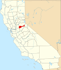
| County | Amador |
| Area | |
• Total | 5.44 sq mi (14.08 km2) |
| • Land | 5.44 sq mi (14.08 km2) |
| • Water | 0 sq mi (0 km2) 0% |
| Elevation | 3,068 ft (935 m) |
| Population | |
• Total | 495 |
| • Density | 91.1/sq mi (35.2/km2) |
| Time zone | UTC-8 (Pacific (PST)) |
| • Summer (DST) | UTC-7 (PDT) |
| ZIP Code | 95689 (Volcano) |
| Area code | 209 |
| FIPS code | 06-42142 |
| GNIS feature ID | 2812656 [2] |
Lockwood is an unincorporated community and census-designated place (CDP) in Amador County, California, United States. It is located north of Volcano and west of Amador Pines.