Pine Grove | |
---|---|
![]() A Chevron gas station in Pine Grove. | |
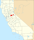
Coordinates: 38°24′47″N120°39′32″W / 38.41306°N 120.65889°W | |
Country | ![]() |
State | ![]() |
County | Amador County |
Area | |
• Total | 18.049 km2 (6.969 sq mi) |
• Land | 18.049 km2 (6.969 sq mi) |
• Water | 0 km2 (0 sq mi) 0% |
Elevation | 766 m (2,513 ft) |
Population | |
• Total | 2,891 |
• Density | 160/km2 (410/sq mi) |
ZIP Code | 95665 |
Area code | 209 |
GNIS feature ID | 1659391; 2583114 |
U.S. Geological Survey Geographic Names Information System: Pine Grove, Amador County, California |
Pine Grove is a census-designated place [4] in Amador County, California. It lies at an elevation of 2513 feet (766 m). The population was 2,219 at the 2010 census.
The current boundaries of Pine Grove include the former mining towns of Clinton and Irishtown. The town also is home to Indian Grinding Rock State Historic Park.
A post office opened in Pine Grove in 1856. [5]
Census | Pop. | Note | %± |
---|---|---|---|
2020 | 2,891 | — | |
U.S. Decennial Census [6] 2010 [7] |
Pine Grove first appeared as a census designated place in the 2010 U.S. Census. [7]
The 2010 United States Census [8] reported that Pine Grove had a population of 2,219. The population density was 318.4 inhabitants per square mile (122.9/km2). The racial makeup of Pine Grove was 2,027 (91.3%) White, 9 (0.4%) African American, 36 (1.6%) Native American, 9 (0.4%) Asian, 6 (0.3%) Pacific Islander, 49 (2.2%) from other races, and 83 (3.7%) from two or more races. Hispanic or Latino of any race were 202 persons (9.1%).
The Census reported that 2,215 people (99.8% of the population) lived in households, 4 (0.2%) lived in non-institutionalized group quarters, and 0 (0%) were institutionalized.
There were 984 households, out of which 215 (21.8%) had children under the age of 18 living in them, 531 (54.0%) were opposite-sex married couples living together, 86 (8.7%) had a female householder with no husband present, 50 (5.1%) had a male householder with no wife present. There were 62 (6.3%) unmarried opposite-sex partnerships, and 2 (0.2%) same-sex married couples or partnerships. 272 households (27.6%) were made up of individuals, and 140 (14.2%) had someone living alone who was 65 years of age or older. The average household size was 2.25. There were 667 families (67.8% of all households); the average family size was 2.68.
The population was spread out, with 363 people (16.4%) under the age of 18, 149 people (6.7%) aged 18 to 24, 332 people (15.0%) aged 25 to 44, 825 people (37.2%) aged 45 to 64, and 550 people (24.8%) who were 65 years of age or older. The median age was 52.7 years. For every 100 females, there were 99.2 males. For every 100 females age 18 and over, there were 97.7 males.
There were 1,140 housing units at an average density of 163.6 per square mile (63.2/km2), of which 984 were occupied, of which 758 (77.0%) were owner-occupied, and 226 (23.0%) were occupied by renters. The homeowner vacancy rate was 3.5%; the rental vacancy rate was 5.4%. 1,668 people (75.2% of the population) lived in owner-occupied housing units and 547 people (24.7%) lived in rental housing units.
In the state legislature, Pine Grove is in the 8th Senate District , represented by Democrat Angelique Ashby, [9] and the 5th Assembly District , represented by Republican Joe Patterson. [10] Federally, Pine Grove is in California's 4th congressional district , represented by Democrat Mike Thompson. [11]
Kirkwood is an unincorporated community in Alpine and Amador counties, California, United States. Kirkwood's main attraction is the Kirkwood Mountain Resort. The town is accessible by State Route 88. Kirkwood is within the Eldorado National Forest. The population was 158 at the 2010 census. For statistical purposes, the United States Census Bureau has defined Kirkwood as a census-designated place (CDP).
Amador City is a city in Amador County, California, United States. The population was 200 as of the 2020 census, up from 185 in 2010, making it the least populous incorporated city in California. Amador City is also noted for being the smallest city in California by area.
Pine Hills is a census-designated place (CDP) in Humboldt County, California, United States, adjacent to Eureka. The population was 3,131 at the 2010 census, up from 3,108 at the 2000 census. Pine Hills includes areas like Ridgewood and areas as far south as the small neighborhood of Elk River. An area near this artificial census construct is called Pine Hill by Local government agencies and officials. Pine Hill is a much smaller area than "Pine Hills" and as defined by local agencies is actually within an adjacent CDP named Bayview.
Lake of the Pines is a census-designated place (CDP) and a gated residential community in Nevada County, California, United States. The population was 3,917 at the 2010 census.
Pine Valley is a community and census-designated place (CDP) in the Cuyamaca Mountains of the Mountain Empire area, in southeastern San Diego County, California. The population was 1,645 at the 2020 census, up from 1,510 at the 2010 census.
Volcano is a census-designated place in Amador County, California. It lies at an elevation of 2,070 feet (631 m). The population was 115 at the 2010 census. It is located at 38°26′35″N120°37′51″W, just north of Pine Grove. The town is registered as a California Historical Landmark. The community is in ZIP code 95689 and area code 209.
Pioneer is a census-designated place in Amador County, California. It is located 5 miles (8.0 km) east-northeast of Pine Grove, at an elevation of 2986 feet, along State Route 88. The community is in ZIP code 95666 and area code 209. The population was 1,094 at the 2010 census.
Buena Vista is a census-designated place in Amador County, California. It lies at an elevation of 295 feet. It is located 4 miles (6.4 km) south-southeast of Ione, at 38°17′40″N120°54′48″W. The community is in ZIP code 95640 and area code 209. The population was 429 at the 2010 census.
Martell is a census-designated place in Amador County, California, United States. It is located 1.5 miles (2.4 km) northwest of Jackson, at an elevation of 1486 feet. The population was 282 at the 2010 census.
Descanso is a small unincorporated community in the Cuyamaca Mountains, within the Mountain Empire area of southeastern San Diego County, California. The community's name is a Spanish word meaning "rest from labor".
Buckhorn is a census-designated place in Amador County, California. Buckhorn sits at an elevation of 3,238 feet. The community is in ZIP code 95666 and area code 209. The 2010 United States census reported Buckhorn's population was 2,429.
Camanche Village is a census-designated place in Amador County, California. It lies at an elevation of 276 feet, and has a population of 847.
River Pines is a census-designated place in Amador County, California. It is located 3 miles (4.8 km) north-northeast of Fiddletown, at an elevation of 1985 feet. A post office opened at River Pines in 1948; it has the zip code of 95675. River Pines has a population of 379.
Fairmead is a census-designated place in Madera County, California, United States. It is located 11 miles (18 km) northwest of Madera, at an elevation of 253 feet (77 m), and bordered to the northwest by Chowchilla. The population was 1,235 at the 2020 census.
California Pines is a census-designated place in Modoc County, California. It lies at an elevation of 4406 feet. Its population is 473 as of the 2020 census, down from 520 from the 2010 census.
Camanche North Shore is a census-designated place in Amador County, California. Camanche North Shore sits at an elevation of 308 feet. The 2010 United States census reported Camanche North Shore's population was 979.
Red Corral is a census-designated place in Amador County, California. Red Corral sits at an elevation of 2710 feet. The 2010 United States census reported Red Corral's population was 1,413.
Pine Canyon is an unincorporated community and census-designated place (CDP) in Monterey County, California, just south of King City. Pine Canyon sits at an elevation of 515 feet (157 m). As of the 2020 census, the population was 1,871.
Spring Valley Lake is a census-designated place in the Victor Valley of the Mojave Desert, within San Bernardino County, California. It is located along the Mojave River.
Pine Flat is a census-designated place (CDP) in Tulare County, California. Pine Flat sits at an elevation of 3,871 feet (1,180 m). The 2020 United States census reported Pine Flat's population was 206, up from 166 at the 2010 census.