Markleeville, California

Last updated
Markleeville
Markleeville Trip (20) (cropped).jpg
Alpine County California Incorporated and Unincorporated areas Markleeville Highlighted.svg
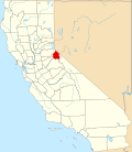
Location in Alpine County and the state of California
USA California location map.svg
Red pog.svg
Markleeville
Location in California
Usa edcp location map.svg
Red pog.svg
Markleeville
Location in the United States
Coordinates: 38°41′42″N119°46′49″W / 38.69500°N 119.78028°W / 38.69500; -119.78028
Country Flag of the United States.svg  United States
State Flag of California.svg  California
County Alpine
Government
   State Senate Brian Dahle (R) [1]
   State Assembly Joe Patterson (R) [2]
   U.S. Congress Mike Thompson (D) [3]
Area
[4]
  Total6.531 sq mi (16.915 km2)
  Land6.531 sq mi (16.915 km2)
  Water0 sq mi (0 km2)  0%
Elevation
5,531 ft (1,686 m)
Population
 (2020)
  Total191
  Density29/sq mi (11/km2)
Time zone UTC-8 (Pacific (PST))
  Summer (DST) UTC-7 (PDT)
ZIP code
96120
Area code 530
FIPS code 06-45988
GNIS feature IDs 1659065, 2408184

Markleeville (formerly, Markleville) [5] is a census-designated place (CDP) and the county seat of Alpine County, California, United States. The population was 191 at the 2020 census, [6] down from 210 at the 2010 census.

Contents

History

The general store. Markleeville - General Store.jpg
The general store.

Jacob J. Marklee founded a toll bridge crossing the Carson River in 1861. He aimed to tap into the traffic from the silver mining boom at Silver Mountain City. On June 23, 1862, he recorded a land claim of 160 acres in Douglas County, Nevada. A boundary survey took place, and the property ended up being in California. In 1863, Marklee died after being involved in a gunfight. When the Comstock Lode discovery took place, the town of Markleeville was founded on the Marklee property. [7] Today, the Alpine County Courthouse sits on the former property, which is listed as a California Historical Landmark. [8]

A post office opened in Markleeville in 1863. [5]

Geography

According to the United States Census Bureau, the CDP has a total area of 6.5 square miles (17 km2), all land. The region comprising Markleeville is Alpine in appearance, with lush grassy valley areas. There is a hot spring, and a state park with a campground. Excellent hiking trails abound.

Climate

According to the Köppen Climate Classification system, Markleeville has a warm-summer Mediterranean climate, abbreviated Csb on climate maps, though it approaches a Humid continental climate (Dsb).

Markleeville has warm to hot summers with only occasional rainfall, mostly from afternoon and evening thunderstorms; nights are usually well below 50 °F (10 °C). Winters are somewhat cold and often snowy. The average January temperatures are a maximum of 45.7 °F or 7.6 °C and a minimum of 17.4 °F or −8.1 °C. The average July temperatures are a maximum of 84.5 °F (29.2 °C) and a minimum of 43.1 °F or 6.2 °C. There are an average of 15.7 afternoons with highs of 90 °F or 32.2 °C or higher and an average of 221.7 mornings with lows of 32 °F or 0 °C or lower, including 5.4 mornings falling to or below 0 °F or −17.8 °C, and 8.1 afternoons that do not top freezing. The record high temperature was 102 °F (38.9 °C) on July 11, 1931. The record low temperature was −25 °F (−31.7 °C) on December 22, 1990.

Average annual precipitation is 19.18 inches or 487.2 millimetres. There are an average of 59 days with measurable precipitation. The wettest calendar year was 1996 with 38.35 inches (974.1 mm) and the driest year was 1917 with 11.74 inches (298.2 mm). The most precipitation in one month occurred in January 1914 with 16.13 inches (409.7 mm). The most precipitation in 24 hours was 4.72 inches (119.9 mm) on December 3, 1950. Average annual snowfall is 82.9 inches or 2.11 metres, and snow depths of over 60 inches or 1.52 metres were recorded during the very cold months of January 1916 and February 1922 – the average depth of snow on the ground in January being 8 inches or 0.20 metres. The snowiest year was 1916 with 144.0 inches (3.66 m), including 99.0 inches (2.51 m) in January 1916. [9]

Climate data for Markleeville, California (045356)
MonthJanFebMarAprMayJunJulAugSepOctNovDecYear
Record high °F (°C)66
(19)
69
(21)
80
(27)
82
(28)
90
(32)
94
(34)
102
(39)
101
(38)
98
(37)
87
(31)
75
(24)
67
(19)
102
(39)
Average high °F (°C)45.7
(7.6)
46.9
(8.3)
53.8
(12.1)
58.9
(14.9)
66.4
(19.1)
75.6
(24.2)
84.5
(29.2)
84.7
(29.3)
77.8
(25.4)
67.0
(19.4)
53.4
(11.9)
44.6
(7.0)
63.3
(17.4)
Average low °F (°C)17.4
(−8.1)
19.0
(−7.2)
23.5
(−4.7)
27.1
(−2.7)
33.1
(0.6)
38.1
(3.4)
43.1
(6.2)
42.1
(5.6)
35.5
(1.9)
28.1
(−2.2)
21.8
(−5.7)
16.3
(−8.7)
28.8
(−1.8)
Record low °F (°C)−20
(−29)
−21
(−29)
−15
(−26)
9
(−13)
10
(−12)
24
(−4)
26
(−3)
25
(−4)
18
(−8)
6
(−14)
−7
(−22)
−25
(−32)
−25
(−32)
Average precipitation inches (mm)3.72
(94)
3.14
(80)
2.10
(53)
1.26
(32)
0.99
(25)
0.60
(15)
0.39
(9.9)
0.46
(12)
0.47
(12)
0.93
(24)
2.11
(54)
3.01
(76)
19.18
(486.9)
Average snowfall inches (cm)21.8
(55)
19.2
(49)
13.1
(33)
4.8
(12)
1.4
(3.6)
0.2
(0.51)
0.0
(0.0)
0.0
(0.0)
0.1
(0.25)
0.6
(1.5)
5.6
(14)
16.1
(41)
82.9
(209.86)
Average precipitation days (≥ 0.01 inch)88655333345760
Source: Western Regional Climate Center [10]

Demographics

2010

At the 2010 census Markleeville had a population of 210. The population density was 32.2 inhabitants per square mile (12.4/km2). The racial makeup of Markleeville was 192 (91%) White, 0 (0%) African American, 4 (2%) Native American, 2 (1%) Asian, 0 (0%) Pacific Islander, 6 (3%) from other races, and 6 (3%) from two or more races. Hispanic or Latino of any race were 11 people (5%). [11]

The whole population lived in households; no one lived in non-institutionalized group quarters and no one was institutionalized.

There were 100 households, 19 (19%) had children under the age of 18 living in them, 47 (47%) were opposite-sex married couples living together, 5 (5%) had a female householder with no husband present, 5 (5%) had a male householder with no wife present. There were 9 (9%) unmarried opposite-sex partnerships, and 1 (1%) same-sex married couples or partnerships. 32 households (32%) were one person and 8 (8%) had someone living alone who was 65 or older. The average household size was 2.1. There were 57 families (57% of households); the average family size was 2.7.

The population was spread out, with 39 people (19%) under the age of 18, 3 people (1%) aged 18 to 24, 42 people (20%) aged 25 to 44, 92 people (44%) aged 45 to 64, and 34 people (16%) who were 65 or older. The median age was 50.8 years. For every 100 females, there were 101.9 males. For every 100 females age 18 and over, there were 101.2 males.

There were 194 housing units at an average density of 29.7 per square mile (11.5/km2), of which 100 were occupied, of which 63 (63%) were owner-occupied, and 37 (37%) were occupied by renters. The homeowner vacancy rate was 2%; the rental vacancy rate was 10%. 133 people (63% of the population) lived in owner-occupied housing units and 77 people (37%) lived in rental housing units.

2000

At the 2000 census there were 197 people, 92 households, and 57 families in the CDP. The population density was 10.3 inhabitants per square mile (4.0/km2). There were 173 housing units at an average density of 9.1 per square mile (3.5/km2). The racial makeup of the CDP was 98% White, 2% Native American, 1% from other races. 2% were Hispanic or Latino of any race. [12]

Of the 92 households, 21% had children under the age of 18 living with them, 51% were married couples living together, 8% had a female householder with no husband present, and 38% were non-families. 30% of households were one person, and 9% were one person aged 65 or older. The average household size was 2.1 and the average family size was 2.6.

The age distribution was 17% under the age of 18, 4% from 18 to 24, 31% from 25 to 44, 34% from 45 to 64, and 15% 65 or older. The median age was 45 years. For every 100 females, there were 95.0 males. For every 100 females age 18 and over, there were 101.2 males.

The median household income was $46,563 and the median family income was $63,750. Males had a median income of $49,375 versus $25,972 for females. The per capita income for the CDP was $40,774. About 7% of families and 15% of the population were below the poverty line, including 25% of those under the age of eighteen and 13% of those 65 or over.

Arts and culture

Markleeville hosts an annual bicycle ride called the Death Ride - Tour of the California Alps. [13] The route goes over five passes for a total distance of 129 miles and over 15,000 feet of elevation gain. In 2010 3,500 riders participated and 2,417 completed the full course of 5 mountain passes. [14]

Related Research Articles

<span class="mw-page-title-main">Iliamna, Alaska</span> Census-designated place in Alaska, United States

Iliamna is a census-designated place (CDP) in Lake and Peninsula Borough, Alaska, United States. The population was 108 at the 2020 census, slightly down from 109 in 2010.

Nelchina is a census-designated place (CDP) in Copper River Census Area, Alaska, United States. The population was 45 at the 2020 census, down from 59 in 2010.

<span class="mw-page-title-main">Sierra Vista Southeast, Arizona</span> CDP in Cochise County, Arizona

Sierra Vista Southeast, often referred to as Hereford or Nicksville, is a census-designated place (CDP) in Cochise County, Arizona, United States. The population was 14,797 at the 2010 census. It includes the neighborhoods Ramsey Canyon, and Sierra Vista Estates within its boundaries.

<span class="mw-page-title-main">Yosemite Valley, California</span> Census-designated place in California, United States

Yosemite Valley is a census-designated place (CDP) in Mariposa County, California, United States. It consists of the developed area of Yosemite Village and the other areas of the Yosemite Valley in Yosemite National Park. The population was 337 at the 2020 census.

<span class="mw-page-title-main">San Ardo, California</span> Unincorporated community in California, United States

San Ardo, formerly known as San Bernardo, is an unincorporated community and census-designated place (CDP) in Monterey County, California, United States. San Ardo is located 18 miles (29 km) southeast of King City at an elevation of 449 feet (137 m). The population was 392 at the 2020 census, down from 517 in 2010.

<span class="mw-page-title-main">Angwin, California</span> Census-designated place in California, United States

Angwin is a census-designated place (CDP) in Napa County, California, best known as the site of Pacific Union College. It is part of the northern San Francisco Bay Area. The population was 3,051 at the 2010 census. Its area code is 707. Its two zip codes are 94508 and 94576. It is in the Pacific time zone.

<span class="mw-page-title-main">East Quincy, California</span> Census-designated place in California, United States

East Quincy is a census-designated place (CDP) in Plumas County, California, United States. The population was 2,489 at the 2010 census, up from 2,398 at the 2000 census.

<span class="mw-page-title-main">Bermuda Dunes, California</span> Census-designated place in California, United States

Bermuda Dunes is a census-designated place (CDP) in Riverside County, California. The population was 7,282 at the 2010 census. Bermuda Dunes is located near Indio and 19 miles (31 km) east of Palm Springs.

<span class="mw-page-title-main">Pine Valley, California</span> Census-designated place in California, United States

Pine Valley is a community and census-designated place (CDP) in the Cuyamaca Mountains of the Mountain Empire area, in southeastern San Diego County, California. The population was 1,510 at the 2010 census, up from 1,501 at the 2000 census.

<span class="mw-page-title-main">Ben Lomond, California</span> Census-designated place in Santa Cruz County, California, United States

Ben Lomond is a census-designated place (CDP) in Santa Cruz County, California, United States, and also the name of the mountain to the west. The CDP includes the communities of Glen Arbor and Brackney. The population was 6,337 at the 2020 census.

<span class="mw-page-title-main">Interlaken, California</span> Census-designated place in California, United States

Interlaken is a census-designated place (CDP) in Santa Cruz County, California, United States. The population was 7,368 at the 2020 census.

<span class="mw-page-title-main">Hayfork, California</span> Census-designated place in California, United States

Hayfork is a census-designated place (CDP) in Trinity County, California, United States. Its population is 2,324 as of the 2020 census, down from 2,368 from the 2010 census.

<span class="mw-page-title-main">Weaverville, California</span> Census-designated place in California, United States

Weaverville is a census-designated place and the county seat of Trinity County, California, United States. Its population is 3,667 as of the 2020 census, up from 3,600 from the 2010 census.

<span class="mw-page-title-main">Groveland-Big Oak Flat, California</span> Unincorporated community in California, United States

Groveland-Big Oak Flat is an unincorporated community and former census-designated place (CDP) in Tuolumne County, California, United States. The population was 3,388 at the 2000 census. This CDP included the communities of Groveland, Big Oak Flat and Pine Mountain Lake (PML).

<span class="mw-page-title-main">Popponesset, Massachusetts</span> Census-designated place in Massachusetts, United States

Popponesset is a census-designated place (CDP) in the town of Mashpee on Cape Cod in Barnstable County, Massachusetts, United States. The population was 220 at the 2010 census.

<span class="mw-page-title-main">Wisdom, Montana</span> Census-designated place in Montana, United States

Wisdom is a small town in Beaverhead County, Montana, United States. The population was 98 at the 2010 census. The ZIP Code of the area is 59761. The town includes three tourist lodgings, service station, grocery, school (K-8), post office and a Forest Service office.

<span class="mw-page-title-main">Sun River, Montana</span> CDP in Montana, United States

Sun River is a census-designated place (CDP) in Cascade County, Montana, United States. The population was 124 at the 2010 census. It is part of the Great Falls, Montana Metropolitan Statistical Area.

<span class="mw-page-title-main">North Beach Haven, New Jersey</span> Populated place in Ocean County, New Jersey, US

North Beach Haven is an unincorporated community and census-designated place (CDP) constituting a part of the Jersey Shore community of Long Beach Township, in southern Ocean County, in the U.S. state of New Jersey. The CDP is situated on Long Beach Island, a barrier island separating Barnegat Bay from the Atlantic Ocean.

<span class="mw-page-title-main">North Valley, New Mexico</span> Census-designated place in New Mexico, United States

North Valley is a census-designated place (CDP) in Bernalillo County, New Mexico, United States. As of the 2010 Census, the CDP population was 11,333. It is part of the Albuquerque Metropolitan Statistical Area.

<span class="mw-page-title-main">Bridgeport, California</span> Census designated place and county seat in California, United States

Bridgeport is an unincorporated community and census-designated place (CDP) in Mono County, California, United States. It is the Mono county seat. The population was 553 at the 2020 census.

References

  1. "Senators". State of California. Retrieved March 18, 2013.
  2. "Members Assembly". State of California. Retrieved March 18, 2013.
  3. "California's 4th Congressional District - Representatives & District Map". Civic Impulse, LLC. Retrieved March 1, 2013.
  4. U.S. Census Archived 2012-01-25 at the Wayback Machine
  5. 1 2 Durham, David L. (1998). California's Geographic Names: A Gazetteer of Historic and Modern Names of the State. Clovis, Calif.: Word Dancer Press. p. 1182. ISBN   1-884995-14-4.
  6. "Markleeville CDP, California". U.S. Census Bureau. Retrieved 15 February 2023.
  7. "Marklee's Cabin Site (No. 240 California Historical Landmark)". Sierra Nevada Geotourism MapGuide. National Geographic. Retrieved 3 September 2012.
  8. "Marklee's Cabin Site". Office of Historic Preservation, California State Parks. Retrieved 2012-03-30.
  9. "MARKLEEVILLE, CALIFORNIA - Climate Summary".
  10. "Period of Record Monthly Climate Summary". Western Regional Climate Center . Retrieved 2014-06-16.
  11. "2010 Census Interactive Population Search: CA - Markleeville CDP". U.S. Census Bureau. Archived from the original on July 15, 2014. Retrieved July 12, 2014.
  12. "U.S. Census website". United States Census Bureau . Retrieved 2008-01-31.
  13. "Course - Death Ride". Death Ride. Retrieved 2016-01-15.
  14. "Rider Stats - Death Ride". Death Ride. Retrieved 2016-01-16.