The Chemehuevi are an indigenous people of the Great Basin. They are the southernmost branch of Southern Paiute. Today, Chemehuevi people are enrolled in the following federally recognized tribes:

Bakersfield is a city in and the county seat of Kern County, California, United States. The city covers about 151 sq mi (390 km2) near the southern end of the San Joaquin Valley, which is located in the Central Valley region.

Tehachapi is a city in Kern County, California, United States, in the Tehachapi Mountains, at an elevation of 3,970 feet (1,210 m), between the San Joaquin Valley and the Mojave Desert. Tehachapi is 35 miles (56 km) east-southeast of Bakersfield, and 20 miles (32 km) west of Mojave. According to the United States Census Bureau, the city has a total area of 10 square miles (26 km2) and a population of 14,414. The Tehachapi area is known for the nearby Tehachapi Loop, the Pacific Crest Trail and for the excellent conditions for the aerial sport of gliding.

The Antelope Valley is located in northern Los Angeles County, California, United States, and the southeast portion of California's Kern County, and constitutes the western tip of the Mojave Desert. It is situated between the Tehachapi, Sierra Pelona, and the San Gabriel Mountains. The valley was named for the pronghorns that roamed there until they were all eliminated in the 1880s, mostly by hunting, or resettled in other areas. The principal cities in the Antelope Valley are Palmdale and Lancaster.

The Tehachapi Mountains are a mountain range in the Transverse Ranges system of California in the Western United States. The range extends for approximately 40 miles (64 km) in southern Kern County and northwestern Los Angeles County and form part of the boundary between the San Joaquin Valley and the Mojave Desert.

Tehachapi Pass is a mountain pass crossing the Tehachapi Mountains in Kern County, California. Traditionally, the pass marks the northeast end of the Tehachapis and the south end of the Sierra Nevada range.

The Mono are a Native American people who traditionally live in the central Sierra Nevada, the Eastern Sierra, the Mono Basin, and adjacent areas of the Great Basin. They are often grouped under the historical label "Paiute" together with the Northern Paiute and Southern Paiute – but these three groups, although related within the Numic group of Uto-Aztecan languages, do not form a single, unique, unified group of Great Basin tribes.

Red Rock Canyon State Park is a state park in the U.S. state of California which features scenic desert cliffs, buttes and spectacular rock formations. The park consists of approximately 27,000 acres (110 km2) within the Mojave Sector of the Tehachapi District of the California State Park System, and is located along State Highway 14 in Kern County, about 80 miles (129 km) east of Bakersfield and 25 miles (40 km) north of Mojave, where the southernmost tip of the Sierra Nevada converges with the El Paso Mountains.

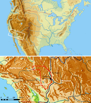
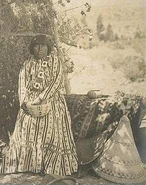
The Kawaiisu are a Native Californian ethnic group in the United States who live in the Tehachapi Valley and to the north across the Tehachapi Pass in the southern Sierra Nevada, toward Lake Isabella and Walker Pass. Historically, the Kawaiisu also traveled eastward on food-gathering trips to areas in the northern Mojave Desert, to the north and northeast of the Antelope Valley, Searles Valley, as far east as the Panamint Valley, the Panamint Mountains, and the western edge of Death Valley. Today, some Kawaiisu people are enrolled in the Tule River Indian Tribe.
The Timbisha are a Native American tribe federally recognized as the Death Valley Timbisha Shoshone Band of California. They are known as the Timbisha Shoshone Tribe and are located in south central California, near the Nevada border. As of the 2010 Census the population of the Village was 124. The older members still speak the ancestral language, also called Timbisha.

The Tübatulabal are an indigenous people of Kern River Valley in the Sierra Nevada range of California. They may have been the first people to make this area their permanent home. Today many of them are enrolled in the Tule River Indian Tribe. They are descendants of the people of the Uto-Aztecan language group, separating from Shoshone people about 3000 years ago.

The Serrano are an indigenous people of California. They use the autonyms of Taaqtam, meaning "people"; Maarrênga’yam, "people from Morongo"; and Yuhaaviatam, "people of the pines." Today the Maarrênga'yam are enrolled in the Morongo Band of Mission Indians, and the Yuhaviatam are enrolled in the San Manuel Band of Mission Indians. Additionally, some Serrano people are enrolled in the Soboba Band of Luiseno Indians.

The Tataviam are a Native American group in Southern California. The ancestral land of the Tataviam people includes northwest present-day Los Angeles County and southern Ventura County, primarily in the upper basin of the Santa Clara River, the Santa Susana Mountains, and the Sierra Pelona Mountains. They are distinct from the Kitanemuk and the Gabrielino-Tongva peoples.
Kawaiisu traditional narratives include myths, legends, tales, and oral histories preserved by the Kawaiisu people of the Tehachapi Mountains, southern Sierra Nevada, and western Mojave Desert of southern California.
Kitanemuk traditional narratives include myths, legends, tales, and oral histories preserved by the Kitanemuk people of the Tehachapi Mountains, southern Sierra Nevada, and the western Mojave Desert of southern California.
The Kawaiisu language is a Uto-Aztecan language spoken by the Kawaiisu people of California.
Tejon Mountain Village is a proposed residential, commercial, and recreational development of pristine, rugged property in the Tehachapi Mountains owned by the Tejon Ranch Company in Lebec, southern Kern County, California. The development includes the largest conservation and land-use agreement in California history. It was approved by the county's Board of Supervisors in October 2009. Opponents launched a legal challenge that was denied in state district court in April 2012.
The Kucadɨkadɨ are a band of Eastern Mono Northern Paiute people who live near Mono Lake in Mono County, California. They are the southernmost band of Northern Paiute.
Panhe was one of the largest Acjachemen villages confirmed to be over 9,600 years old, and a current sacred, ceremonial, cultural, and burial site for the Acjachemen people. The site of Panhe is now within San Onofre State Beach, San Diego County, California, located at the mouth of San Mateo Canyon and Cristianitos Canyon, and approximately 3.7 miles (6.0 km) upstream from the Pacific Ocean. Mission's records have shown evidence of many Acjachemen's ancestry in Panhe.