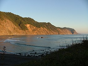
Olympic National Park is an American national park located in the State of Washington, on the Olympic Peninsula. The park has four regions: the Pacific coastline, alpine areas, the west side temperate rainforest and the forests of the drier east side. Within the park there are three distinct ecosystems which are subalpine forest and wildflower meadow, temperate forest, and the rugged Pacific coast.

Sequoia National Park is an American national park in the southern Sierra Nevada east of Visalia, California. The park was established on September 25, 1890 to protect 404,064 acres of forested mountainous terrain. Encompassing a vertical relief of nearly 13,000 feet (4,000 m), the park contains the highest point in the contiguous United States, Mount Whitney, at 14,505 feet (4,421 m) above sea level. The park is south of, and contiguous with, Kings Canyon National Park; both parks are administered by the National Park Service together as the Sequoia and Kings Canyon National Parks. UNESCO designated the areas as Sequoia-Kings Canyon Biosphere Reserve in 1976.

State Route 133 is a state highway in the U.S. state of California, serving as an urban route in Orange County. It connects SR 1 in Laguna Beach through the San Joaquin Hills with several freeways in Irvine, ending at the SR 241, a toll road in the latter city. It is built as an expressway from SR 73 to Laguna Canyon Road, and past this, SR 133 is a freeway to I-5, and a tollway to SR 241 near the Santa Ana Mountains.

State Route 74, part of which forms the Palms to Pines Scenic Byway or Pines to Palms Highway, and the Ortega Highway, is a state highway in the U.S. state of California. It runs from Interstate 5 in San Juan Capistrano in Orange County to the city limits of Palm Desert in Riverside County. Stretching about 111 miles (179 km), it passes through several parks and National Forests between the Pacific coast and the Coachella Valley.
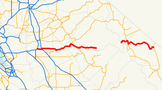
State Route 120 is a state highway in the U.S. state of California, running west to east across the central part of the state. It runs from Interstate 5 in the San Joaquin Valley near Lathrop through Yosemite National Park, to its end at U.S. Route 6 in Mono County, eastern California. While the route is signed as a contiguous route through Yosemite National Park, the portion in park boundaries is federally maintained, and is not included in the state route logs. The portion at Tioga Pass is the highest paved through road in the California State Route system. This part is not maintained in the winter and is usually closed during the winter season.
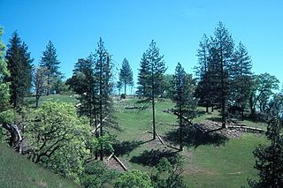
Henry W. Coe State Park is a state park of California, USA, preserving a vast tract of the Diablo Range. The park is located closest to the city of Morgan Hill, and is located in both Santa Clara and Stanislaus counties. The park contains over 87,000 acres (35,000 ha), making it the largest state park in northern California, and the second-largest in the state. Managed within its boundaries is a designated wilderness area of about 22,000 acres (8,900 ha). This is officially known as the Henry W. Coe State Wilderness, but locally as the Orestimba Wilderness. The 89,164-acre (36,083 ha) park was established in 1959.
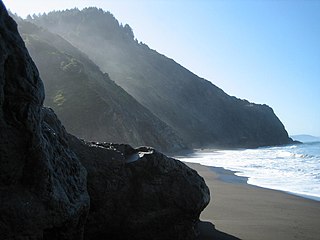
The Lost Coast is a mostly natural and undeveloped area of the California North Coast in Humboldt and Mendocino Counties, which includes the King Range. It was named the "Lost Coast" after the area experienced depopulation in the 1930s. In addition, the steepness and related geotechnical challenges of the coastal mountains made this stretch of coastline too costly for state highway or county road builders to establish routes through the area, leaving it the most undeveloped and remote portion of the California coast. Without any major highways, communities in the Lost Coast region such as Petrolia, Shelter Cove, and Whitethorn are isolated from the rest of California.

The King Range is a mountain range of the Outer Northern California Coast Ranges System, located entirely within Humboldt County on the North Coast of California.
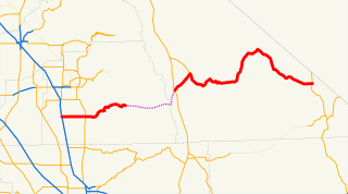
State Route 190 is a state highway in the U.S. state of California that is split into two parts by the Sierra Nevada. The western portion begins at Tipton at a junction with State Route 99 and heads east towards Porterville before ending at Quaking Aspen in the Sequoia National Forest. The eastern portion begins at US 395 at Olancha, heads east through Death Valley National Park, and ends at State Route 127 at Death Valley Junction. The 43.0-mile (69.2 km) portion over the Sierra Nevada remains unconstructed, and the California Department of Transportation (Caltrans) has no plans to build it through the wilderness areas. SR 190 is a National Scenic Byway known as the Death Valley Scenic Byway.

Petrolia is an unincorporated community in Humboldt County, California, 10 miles (16 km) southeast of Cape Mendocino, at an elevation of 121 feet (37 m) above sea level, within ZIP Code 95558, and area code 707. Petrolia was the site of the first oil well drilled in California.

Shelter Cove is a census-designated place in Humboldt County, California. It lies at an elevation of 138 feet. Shelter Cove is on California's Lost Coast where the King Range meets the Pacific Ocean. A nine-hole golf course surrounds the one-runway Shelter Cove Airport at the center of Shelter Cove's commercial district. Utilities are provided by the Humboldt County Resort Improvement District #1 and boating access to the sea is managed by the Humboldt Bay Harbor, Recreation & Conservation District. The population was 693 at the 2010 census.

The Darwin Falls Wilderness is a protected area in the northern Mojave Desert adjacent to Death Valley National Park. The 8,189-acre (3,314 ha) wilderness area was created by the California Desert Protection Act of 1994 and is managed by the Bureau of Land Management as part of the National Wilderness Preservation System.
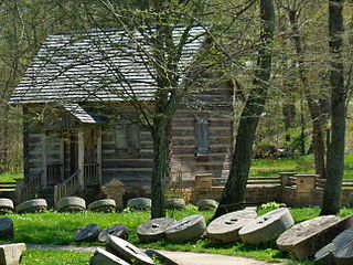
Levi Jackson Wilderness Road Park is a former state park located just south of London, Kentucky in Laurel County. It is now a city park under the auspices of the city of London, KY. The park encompasses 896 acres (363 ha) and includes a section of the Wilderness Road that early settlers used to reach Kentucky. The park is named for Levi Jackson, an early Kentucky pioneer. It serves as both a recreational and historic park.

Russian Gulch State Park is a California State Park in coastal Mendocino County, California, 2 mi (3.2 km) north of Mendocino and 7 mi (11 km) south of Fort Bragg.

The Golden Trout Wilderness is a federally designated wilderness area in the Sierra Nevada, in Tulare County and Inyo County, California. It is located 40 miles (64 km) east of Porterville, California within Inyo National Forest and Sequoia National Forest.

The King Range Wilderness is a 42,585-acre (172 km2) federally designated wilderness area within the King Range National Conservation Area in northern California, United States. The area was set aside with the passage of the Northern California Coastal Wild Heritage Wilderness Act of 2006. The Bureau of Land Management is the responsible agency and is currently working on a Management Plan for the King Range Wilderness. This section of California's coastline is known as the "Lost Coast", a landscape too rugged for highway building, which forced the construction of State Highway 1 and U.S. 101 inland. The King Range Wilderness is the longest undeveloped coast, outside of Alaska, in the United States.

Camp Grant is a ghost town in Humboldt County located on the South Fork Eel River 2 miles (3.2 km) northeast of Weott and 3 miles (4.8 km) east of Dyerville. It was originally settled by Northern Sinkyone people, followed by a Union Army camp and later a logging and railroad support settlement for the construction of the Northwestern Pacific Railroad.

Wheeler is an unincorporated community in Mendocino County, California. It is located 8.5 miles (14 km) southwest of Piercy, at an elevation of 43 feet. Wheeler was a company town built adjacent to Jackass Creek for logging operations from 1948 to 1959. Sinkyone Wilderness State Park acquired the Lost Coast property after 1975. No structures remain at the location now used as a campground.

Usal Creek is the southernmost drainage basin unbridged by California State Route 1 on California's Lost Coast. The unpaved county road following the westernmost ridge line south from the King Range crosses Usal Creek near the Pacific coast, but the bridge may be removed during winter months. Usal Creek, 9.7 miles (15.6 km) long, drains about 28 square miles (73 km2) on the Mendocino Coast and empties into the Pacific Ocean near the former company town of Usal.
