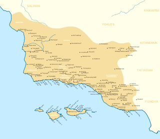
The Chumash are a Native American people of the central and southern coastal regions of California, in portions of what is now Kern, San Luis Obispo, Santa Barbara, Ventura and Los Angeles counties, extending from Morro Bay in the north to Malibu in the south to Mt Pinos in the east. Their territory included three of the Channel Islands: Santa Cruz, Santa Rosa, and San Miguel; the smaller island of Anacapa was likely inhabited seasonally due to the lack of a consistent water source.
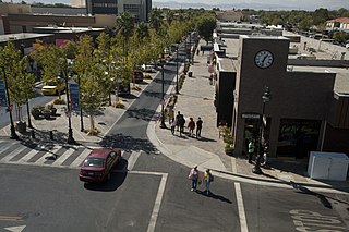
Lancaster is a charter city in northern Los Angeles County, in the Antelope Valley of the western Mojave Desert in Southern California. As of the 2020 census, the population was 173,516, making Lancaster the 153rd largest city in the United States and the 30th largest in California. Lancaster is a twin city with its southern neighbor Palmdale; together, they are the principal cities within the Antelope Valley region.
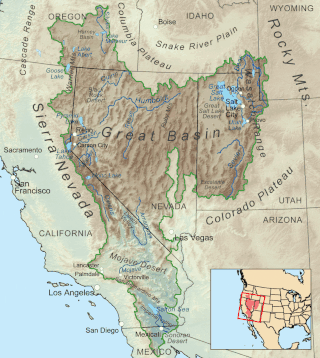
The Great Basin is the largest area of contiguous endorheic watersheds, those with no outlets, in North America. It spans nearly all of Nevada, much of Utah, and portions of California, Idaho, Oregon, Wyoming, and Baja California. It is noted for both its arid climate and the basin and range topography that varies from the North American low point at Badwater Basin in Death Valley to the highest point of the contiguous United States, less than 100 miles (160 km) away at the summit of Mount Whitney. The region spans several physiographic divisions, biomes, ecoregions, and deserts.

The Pomo are a Native American people of California. Historical Pomo territory in Northern California was large, bordered by the Pacific Coast to the west, extending inland to Clear Lake, and mainly between Cleone and Duncans Point. One small group, the Tceefoka, lived in the vicinity of present-day Stonyford in Colusa County, separated from the core Pomo area by lands inhabited by Yuki and Wintuan speakers.

The Sonoran Desert is a desert in North America and ecoregion that covers the northwestern Mexican states of Sonora, Baja California, and Baja California Sur, as well as part of the southwestern United States. It is the hottest desert in both Mexico and the United States. It has an area of 260,000 square kilometers (100,000 sq mi).

The Antelope Valley is located in northern Los Angeles County, California, United States, and the southeast portion of California's Kern County, and constitutes the western tip of the Mojave Desert. It is situated between the Tehachapi, Sierra Pelona, and the San Gabriel Mountains. The valley was named for the pronghorns that roamed there until they were all eliminated in the 1880s, mostly by hunting, or resettled in other areas. The principal cities in the Antelope Valley are Palmdale and Lancaster.

The Maidu are a Native American people of northern California. They reside in the central Sierra Nevada, in the watershed area of the Feather and American Rivers and in Humbug Valley. In Maiduan languages, maidu means "man".

Fort Ross is a former Russian establishment on the west coast of North America in what is now Sonoma County, California. It was the hub of the southernmost Russian settlements in North America from 1812 to 1841. Notably, it was the first multi-ethnic community in northern California, with a combination of Native Californians, Native Alaskans, and Russians. It has been the subject of archaeological investigation and is a California Historical Landmark, a National Historic Landmark, and on the National Register of Historic Places. It is part of California's Fort Ross State Historic Park.

The Indigenous peoples of the Great Basin are Native Americans of the northern Great Basin, Snake River Plain, and upper Colorado River basin. The "Great Basin" is a cultural classification of indigenous peoples of the Americas and a cultural region located between the Rocky Mountains and the Sierra Nevada, in what is now Nevada, and parts of Oregon, California, Idaho, Wyoming, and Utah. The Great Basin region at the time of European contact was ~400,000 sq mi (1,000,000 km2). There is very little precipitation in the Great Basin area which affects the lifestyles and cultures of the inhabitants.

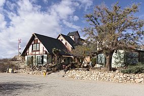
The Stagecoach Inn Museum in Newbury Park, California, originally known as the Grand Union Hotel, was used as a resting area for people who traveled from Los Angeles to Santa Barbara. Besides a hotel and stagecoach stop, it has also been used as a post office, church, restaurant and military school. It is California Historical Landmark No. 659 and is listed in the National Register of Historic Places. It played a major role in the development of the stage line transportation network in California. The hotel was also the first business venture in the Conejo Valley.

The Mono are a Native American people who traditionally live in the central Sierra Nevada, the Eastern Sierra, the Mono Basin, and adjacent areas of the Great Basin. They are often grouped under the historical label "Paiute" together with the Northern Paiute and Southern Paiute – but these three groups, although related within the Numic group of Uto-Aztecan languages, do not form a single, unique, unified group of Great Basin tribes.

Indian Grinding Rock State Historic Park is a California State Park, preserving an outcropping of marbleized limestone with some 1,185 mortar holes—the largest collection of bedrock mortars in North America. It is located in the Sierra Nevada foothills, 8 miles (13 km) east of Jackson. The park is nestled in a little valley 2,400 feet (732 m) above sea level, with open meadows and large specimens of valley oak that once provided the Miwok peoples of this area with an ample supply of acorns. The 135-acre (55 ha) park was established in 1962 and listed on the National Register of Historic Places in 1971.

The Kawaiisu are a Native Californian ethnic group in the United States who live in the Tehachapi Valley and to the north across the Tehachapi Pass in the southern Sierra Nevada, toward Lake Isabella and Walker Pass. Historically, the Kawaiisu also traveled eastward on food-gathering trips to areas in the northern Mojave Desert, to the north and northeast of the Antelope Valley, Searles Valley, as far east as the Panamint Valley, the Panamint Mountains, and the western edge of Death Valley. Today, some Kawaiisu people are enrolled in the Tule River Indian Tribe.
The Timbisha are a Native American tribe federally recognized as the Death Valley Timbisha Shoshone Band of California. They are known as the Timbisha Shoshone Tribe and are located in south central California, near the Nevada border. As of the 2010 Census the population of the Village was 124. The older members still speak the ancestral language, also called Timbisha.

The Institute of American Indian Arts (IAIA) is a public tribal land-grant college in Santa Fe, New Mexico, United States. The college focuses on Native American art. It operates the Museum of Contemporary Native Arts (MoCNA), which is housed in the historic Santa Fe Federal Building, a landmark Pueblo Revival building listed on the National Register of Historic Places as Federal Building. The museum houses the National Collection of Contemporary Indian Art, with more than 7,000 items.

The Tataviam are a Native American group in Southern California. The ancestral land of the Tataviam people includes northwest present-day Los Angeles County and southern Ventura County, primarily in the upper basin of the Santa Clara River, the Santa Susana Mountains, and the Sierra Pelona Mountains. They are distinct from the Kitanemuk and the Gabrielino-Tongva peoples.
The traditional narratives of Native California are the folklore and mythology of the native people of California. For many historic nations of California, there is only a fragmentary record of their traditions. Spanish missions in California from the 18th century Christianized many of these traditions, and the remaining groups were mostly assimilated to US culture by the early 20th century. While there are sparse records from the 18th century, most material was collected during the 19th and the early 20th centuries.

High Desert is a vernacular region with non-discrete boundaries covering areas of the western Mojave Desert in Southern California. The region encompasses various terrain with elevations generally between 2,000 and 4,000 ft above sea level, and is located just north of the San Gabriel, San Bernardino, and Little San Bernardino Mountains.

Caddo Mounds State Historic Site (41CE19) is an archaeological site in Weeping Mary, Texas. This Caddoan Mississippian culture site is composed of a village and ceremonial center that features two earthwork platform mounds and one burial mound. Located on an ancient Native American trail later named by the Spanish as El Camino Real de los Tejas, the settlement developed hundreds of years before the arrival of Europeans to the region. Archaeologists believe the site was created in approximately 800 CE, with most major construction taking place between 1100 and 1300 CE.