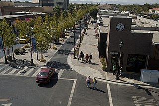
Lancaster is a charter city in northern Los Angeles County, in the Antelope Valley of the western Mojave Desert in Southern California. As of the 2010 census it had a population of 156,633, and in 2020 the population was estimated at 173,516, making Lancaster the 153rd largest city in the United States and the 30th largest in California. Lancaster is part of a twin city complex with its southern neighbor Palmdale, and together they are the principal cities within the Antelope Valley region.

The Mojave Desert is a xeric desert in the rain shadow of the Sierra Nevada mountains in the Southwestern United States. It is named for the indigenous Mojave people. It is located primarily in southeastern California and southwestern Nevada, with small portions extending into Arizona and Utah.

Mojave National Preserve is a United States National Preserve located in the Mojave Desert of San Bernardino County, California, USA, between Interstate 15 and Interstate 40. The preserve was established October 31, 1994, with the passage of the California Desert Protection Act by the US Congress. Previously, it was the East Mojave National Scenic Area, under the jurisdiction of the Bureau of Land Management. At 1,542,776 acres (6,243 km2), it is the third largest unit of the National Park System in the contiguous United States.

Antelope Valley California Poppy Reserve is a state-protected reserve of California, United States, harboring the most consistent blooms of California poppies, the state flower. The reserve is located in the rural west side of Antelope Valley in northern Los Angeles County, 15 miles (24 km) west of Lancaster. To the north is Kern County. The reserve is at an elevation ranging from 2,600 to 3,000 feet above sea level, in the Mojave Desert climate zone. The reserve is administered by the California Department of Parks and Recreation. Other wildflowers within the reserve include the owl's clover, lupine, goldfields, cream cups and coreopsis.

The Antelope Valley is located in northern Los Angeles County, California, and the southeast portion of Kern County, California, and constitutes the western tip of the Mojave Desert. It is situated between the Tehachapi, Sierra Pelona, and the San Gabriel Mountains. The valley was named for the pronghorns that roamed there until they were all but eliminated in the 1880s, mostly by hunting, or resettled in other areas. The principal cities in the Antelope Valley are Palmdale and Lancaster.

The ecology of California can be understood by dividing the state into a number of ecoregions, which contain distinct ecological communities of plants and animals in a contiguous region. The ecoregions of California can be grouped into four major groups: desert ecoregions, Mediterranean ecoregions, forested mountains, and coastal forests.

Spring Mountain Ranch State Park is a public recreation area located within the Red Rock Canyon National Conservation Area in Nevada's Cottonwood Valley, five miles (8.0 km) northwest of Blue Diamond, Nevada. The state park preserves the historic Sandstone Ranch, which was entered into the National Register of Historic Places as a historic district in 1976.
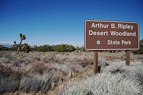
Saddleback Butte State Park is a state park in the Antelope Valley of the western Mojave Desert, in Southern California. It is located east of Lancaster, north of the community of Lake Los Angeles, and south of Edwards in the unincorporated community of Hi Vista.
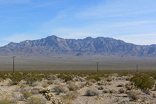
The Providence Mountains are found in the eastern Mojave Desert of San Bernardino County, California, U.S. The range reaches an elevation of 7,162 feet (2,183 m) at Edgar Peak and is home to the Mitchell Caverns Natural Preserve in the Providence Mountains State Recreation Area, and the Mojave National Preserve.

The Darwin Falls Wilderness is a protected area in the northern Mojave Desert adjacent to Death Valley National Park. The 8,189-acre (3,314 ha) wilderness area was created by the California Desert Protection Act of 1994 and is managed by the Bureau of Land Management as part of the National Wilderness Preservation System.

High Desert is an informal designation, with non-discrete boundaries, applied to areas of the Mojave Desert in southern California that are generally between 2,000 feet (610 m) and 4,000 feet (1,200 m) in elevation, and located just north of the San Gabriel, San Bernardino and Little San Bernardino Mountains.

Quail Mountain, at 5,816 feet (1,773 m), is the highest mountain in Joshua Tree National Park and the highest point in the Little San Bernardino Mountains of the very southern reach of the Mojave Desert. It is one of the southernmost peaks in the Transverse Ranges, with the Peninsular Ranges just across the Colorado Desert and Coachella Valley.

The Kiavah Wilderness is a federally designated wilderness area located in the Mojave Desert, Scodie Mountains, and southern Sierra Nevada in Kern County, California, United States. California State Route 178 connects the town of Lake Isabella to State Highway 14 in the east, crossing Walker Pass at the north boundary of the wilderness.
The Piper Mountain Wilderness is a federally designated wilderness area located in the White Mountains 20 miles (32 km) northeast of Big Pine, California in Inyo County, California.

Joshua Tree National Park is an American national park in southeastern California, east of San Bernardino and Los Angeles and north Palm Springs. It is named after the Joshua trees native to the Mojave Desert. Originally declared a national monument in 1936, Joshua Tree was redesignated as a national park in 1994 when the U.S. Congress passed the California Desert Protection Act. Encompassing a total of 790,636 acres – slightly larger than the state of Rhode Island – the park includes 429,690 acres of designated wilderness. Straddling San Bernardino and Riverside Counties, the park includes parts of two deserts, each an ecosystem whose characteristics are determined primarily by elevation: the higher Mojave Desert and the lower Colorado Desert. The Little San Bernardino Mountains traverse the southwest edge of the park.
The Sylvania Mountains Wilderness is a federally designated wilderness area located 30 miles (48 km) east of Bishop in the state of California. The wilderness is 18,677acres in size and is managed by the Bureau of Land Management (BLM). The California Desert Protection Act of 1994 created the Sylvania Mountains Wilderness and was added to the National Wilderness Preservation System. The wilderness is bordered by Nevada stateline on the east, Piper Mountain Wilderness on the west and Death Valley National Park to the south.

The Cleghorn Lakes Wilderness is a 33,475-acre (135.47 km2) wilderness area in the southern Mojave Desert. It is located 16 miles (26 km) northeast of Twentynine Palms, California, and 20 miles (32 km) north of Joshua Tree National Park. It is managed by the Bureau of Land Management.
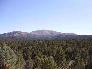
Pinyon–juniper woodland, also spelled piñon–juniper woodland, is a vegetation type (biome) of Western United States higher elevation deserts, characterized by being an open forest dominated by low, bushy, evergreen junipers, pinyon pines, and their associates which vary from region to region. The woodland's density and crown height varies dramatically depending on the site's soil and climate, the age of the stand, and the particular species present, with mature trees ranging in height from from as low as 2 meters up to 15 meters. At lower elevations, junipers often predominate and trees are spaced widely, bordering on and mingling with grassland or shrubland. As elevation increases, pinyon pines become common and trees grow closer, forming denser canopies. Historically, pinyon-juniper woodland has provided a vital source of fuel and food for peoples of the American Southwest.

Sand to Snow National Monument is a U.S. National Monument located in San Bernardino County and northern Riverside County, Southern California.