San Mateo County, officially the County of San Mateo, is a county located in the U.S. state of California. As of the 2020 census, the population was 764,442. Redwood City is the county seat, and the third most populated city following Daly City and San Mateo. San Mateo County is included in the San Francisco-Oakland-Berkeley, CA MSA, Silicon Valley, and is part of the San Francisco Bay Area, the nine counties bordering San Francisco Bay. It covers most of the San Francisco Peninsula. San Francisco International Airport is located in the northeastern area of the county and is approximately 7 miles south of the city and county limits of San Francisco, even though the airport itself is assigned a San Francisco postal address. The county's built-up areas are mostly suburban, and are home to several corporate campuses.

Gaspar de Portolá y Rovira was a Spanish military officer, best known for leading the Portolá expedition into California and for serving as the first Governor of the Californias. His expedition laid the foundations of important Californian cities like San Diego and Monterey, and bestowed names to geographic features throughout California, many of which are still in use.

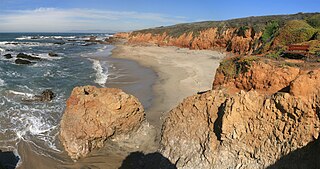
Año Nuevo State Park is a state park of California, United States, encompassing Año Nuevo Island and Año Nuevo Point, which are known for their pinniped rookeries. Located in San Mateo County, the low, rocky, windswept point juts out into the Pacific Ocean about 55 miles (89 km) south of San Francisco and the Golden Gate. Año Nuevo State Natural Reserve, formerly a separate unit of the California state park system, was merged into Año Nuevo State Park in October 2008. The coastal geographic center, or coastal-midpoint of California is located at the Northern end of this park at N 37°09′58″, W 122°21'40", as the absolute geographic center of California falls at N 37°09′58″, W 119°26′58″W.

Pescadero is an unincorporated town and census-designated place (CDP) in San Mateo County, California, two miles (3 km) east of State Route 1 and Pescadero State Beach. The town is 14.4 miles (23.2 km) south of Half Moon Bay. The ZIP Code is 94060 and the community is inside area code 650. The population was 595 at the 2020 census.

Portola Redwoods State Park is a 2,800 acres (1,100 ha) state park in California situated in San Mateo County. The parks' primary watercourses — Peters Creek, Pescadero Creek and their associated tributaries — converge at Portola Redwoods State Park. Tip Toe Falls is a small waterfall along Fall Creek, a tributary of Pescadero Creek.
San Gregorio is an unincorporated community in San Mateo County, California, with a population of 214 people. It is located in the San Francisco Bay Area, south of Half Moon Bay. Just east of Highway 1, it is one mile (1.6 km) inland on Highway 84, from San Gregorio State Beach. It is also located 7 (11.4 km) north of Pescadero via Stage Road and 8 miles (12.8 km) west of La Honda via SR 84.

Half Moon Bay State Beach is a 4-mile (6 km) stretch of protected beaches in the state park system of California, United States, on Half Moon Bay. From north to south it comprises Roosevelt, Dunes, Venice, and Francis Beaches. The 181-acre (73 ha) park was established in 1956.
Carmel River State Beach is a state park unit at the mouth of Carmel Valley, California, United States, featuring a 1-mile-long (1.6 km) protected beach with a lagoon formed by the Carmel River. The lagoon attracts many migratory birds. The state beach includes Monastery Beach, which is popular with scuba divers. Sea kayakers also frequent the beach, which has easy access to the natural reserves of Point Lobos. The 297-acre (120 ha) park was established in 1953.
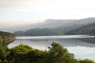
Crystal Springs Reservoir is a pair of artificial lakes located in the northern Santa Cruz Mountains of San Mateo County, California situated in the rift valley created by the San Andreas Fault just to the west of the cities of San Mateo and Hillsborough, and I-280. The lakes are part of the San Mateo Creek watershed.

Montara State Beach is a beach located in the coastal region of the U.S. state of California, eight miles north of Half Moon Bay on State Route 1. It is operated by the California State Department of Parks and Recreation under the San Mateo Coast Sector Office. It is one of the cleanest beaches in the state and is known for surfing and fishing.
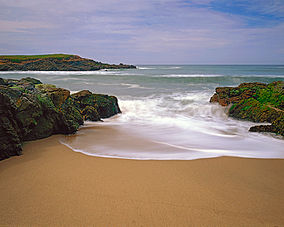
Pescadero State Beach is alongside State Route 1, located 14.5 miles south of Half Moon Bay and 1.5 miles west of the city of Pescadero in San Mateo County, California. The beach has a mile-long shoreline with sandy coves, rocky cliffs, tide pools, fishing spots and picnic facilities.

The Sánchez Adobe Park, home to the Sánchez Adobe, is located in Pacifica, California, at 1000 Linda Mar Boulevard, on the north bank of San Pedro Creek, approximately 0.91 miles (1,470 m) from the Pacific Ocean in Linda Mar Valley. The 5.46-acre (2.21 ha) county park, established in 1947 contains the Sanchez Adobe Historical site, designated a National Register Historical District in 1976 and is California registered landmark 391.

Pillar Point Harbor is a boat harbor created by a riprap breakwater in San Mateo County, California immediately north of Half Moon Bay. It is used by both pleasure craft and small commercial fishing boats.

San Mateo Creek is a perennial stream whose watershed includes Crystal Springs Reservoir, for which it is the only natural outlet after passing Crystal Springs Dam.
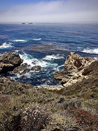
Garrapata State Park is a state park of California, United States, located on California State Route 1 6.7 miles (10.8 km) south of Carmel and 18 miles (29 km) north of Big Sur Village on the Monterey coast. The 2,939-acre (1,189 ha) park was established in 1979. California sea lions, harbor seals and sea otters frequent the coastal waters while gray whales pass close by during their yearly migration.
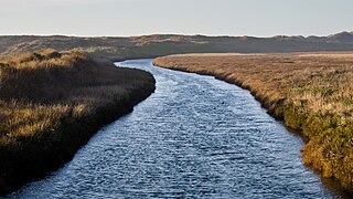
Pescadero Creek is a major stream in Santa Cruz and San Mateo counties in California, United States. At 26.6 miles (42.8 km), it is the longest stream in San Mateo County and flows all year from springs in the Santa Cruz Mountains. Its source is at 1,880 feet (570 m) above sea level on the western edge of Castle Rock State Park, with additional headwaters in Portola Redwoods State Park, and its course traverses Pescadero Creek County Park and San Mateo County Memorial Park before entering Pescadero Marsh Natural Preserve at Pescadero State Beach and thence to the Pacific Ocean 14.4 miles (23 km) south of Half Moon Bay.

San Mateo County's Memorial Park is located in Loma Mar and is operated by the San Mateo County Department of Parks. The park encompasses 673 acres (2.72 km2), and includes old-growth redwood trees, eight miles (13 km) of hiking trails, camping areas, picnic facilities, a visitor center, a camp store, a creek swimming area, and campfire programs. Pescadero Creek, which provides winter habitat for steelhead trout, runs through the park. Bloomquist, Hoffman, McCormick, and Peterson Creeks join Pescadero Creek within the park boundaries.
One of the six Boy Scouts of America councils that serves the San Francisco Bay area, the Pacific Skyline Council was founded in 1940 as the Stanford Area Council (#031). In 1994, the Stanford Area Council merged with the San Mateo County Council (#020) to form the current council which serves youth in San Mateo County and northern Santa Clara county.

San Mateo County's Pescadero Creek Park is located near Loma Mar and is operated by the San Mateo County Department of Parks. The park complex of 8,020 acres (32.5 km2) also includes the neighboring Memorial, Sam McDonald and Heritage Grove parks. The park borders Portola Redwoods State Park with seamless trails, and connects to Big Basin Redwoods State Park via a trail easement across private lands.

San Mateo County's Sam McDonald Park is located between La Honda and Loma Mar and is operated by the San Mateo County Department of Parks. The park is 867 acres (3.51 km2) of redwood forest, mixed woods and open meadows. Trails climb up to a ridgeline with views across the Pescadero Creek valley, Butano Ridge, and the Pacific Ocean. The park includes Heritage Grove and borders Pescadero Creek County Park through which it connects to Memorial County Park, Portola Redwoods State Park, and Big Basin Redwoods State Park. Horseback riding is popular here, and many use Jack Brook Horse Camp.