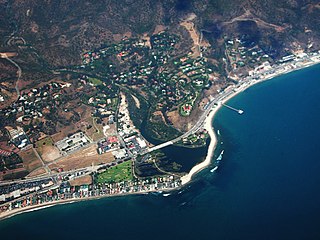
Malibu is a beach city in the Santa Monica Mountains region of Los Angeles County, California, about 30 miles (48 km) west of Downtown Los Angeles. It is known for its Mediterranean climate, its strip of beaches stretching 21 miles along the Pacific Ocean coast, and for its longtime status as the home of numerous affluent Hollywood celebrities and executives. Although a high proportion of its residents are entertainment industry figures with multi-million dollar mansions, Malibu also features several middle- and upper-middle-class neighborhoods. The Pacific Coast Highway traverses the city, following along the South Coast of California. As of the 2020 census, the city's population was 10,654. The ongoing 2025 Palisades Fire devastated Malibu, with almost all of the beachfront homes near its center destroyed.

Chatsworth is a suburban neighborhood in Los Angeles, California, in the San Fernando Valley.

The Santa Monica Mountains are a coastal mountain range in Southern California, next to the Pacific Ocean. It is part of the Transverse Ranges. The Santa Monica Mountains National Recreation Area encompasses this mountain range. Because of its proximity to densely populated regions, it is one of the most visited natural areas in California.

Pacific Palisades is a neighborhood in the Westside region of Los Angeles, California, situated about 20 miles (32 km) west of Downtown Los Angeles.
The Santa Monica Mountains Conservancy is an agency of the state of California in the United States founded in 1980 and dedicated to the acquisition of land for preservation as open space, for wildlife and California native plants habitat Nature Preserves, and for public recreation activities.

Malibu Creek State Park is a state park of California, United States, preserving the Malibu Creek canyon in the Santa Monica Mountains. The 8,215-acre (3,324 ha) park was established in 1974. Opened to the public in 1976, the park is also a component of Santa Monica Mountains National Recreation Area.

Topanga is an unincorporated community in western Los Angeles County, California, United States. Located in the Santa Monica Mountains, the community exists in Topanga Canyon and the surrounding hills. The narrow southern portion of Topanga at the coast is between the city of Malibu and the Los Angeles neighborhood of Pacific Palisades. As of the 2020 census the population of the Topanga CDP was 8,560. For statistical purposes, the United States Census Bureau has defined Topanga as a census-designated place (CDP). The ZIP code is 90290 and the area code is primarily 310, with 818 only at the north end of the canyon. It is in the 3rd County Supervisorial district.

Rocky Peak, located in Rocky Peak Park, is the fourth-highest point in the Santa Susana Mountains, and overlooks the San Fernando Valley and Chatsworth, the Simi Hills, and the Simi Valley in Southern California. The peak, which is 2,715 feet (828 m) in elevation, sits on the Los Angeles County–Ventura County line.

Topanga State Park is a California state park located in the Santa Monica Mountains, within Los Angeles County, California. It is part of the Santa Monica Mountains National Recreation Area.

The Upper Las Virgenes Canyon Open Space Preserve is a large open space nature preserve owned and operated by the Santa Monica Mountains Conservancy spanning nearly 3,000 acres (1,200 ha) in the Simi Hills of western Los Angeles County and eastern Ventura County.

The Santa Monica Mountains National Recreation Area is a United States national recreation area containing many individual parks and open space preserves, located primarily in the Santa Monica Mountains of Southern California. The SMMNRA is in the greater Los Angeles region, with two thirds of the parklands in northwest Los Angeles County, and the remaining third, including a Simi Hills extension, in southeastern Ventura County.

The Western Los Angeles County Council (WLACC) (#051) is one of five Boy Scouts of America councils in Los Angeles County, California. Headquartered in Van Nuys, the council services over 30,000 youth spanning six districts including the San Fernando Valley, Santa Clarita Valley, Antelope Valley, Malibu, and much of West Los Angeles.

Spahn Ranch, also known as the Spahn Movie Ranch, was a 55-acre movie ranch in Los Angeles, California. For a period it was used as a ranch, dairy farm and later movie set during the era of westerns. After a decline in use for filming by the 1950s, its owner George Spahn established a stable for renting horses for riding on the varied acres. It became known in the late 20th century as the primary headquarters of Charles Manson and his cult followers, the "Manson Family", for much of 1967 and 1968. They were notorious for the Tate–LaBianca murders of August 1969.
A movie ranch is a ranch that is at least partially dedicated for use as a set in the creation and production of motion pictures and television shows. These were developed in the United States in southern California, because of the climate.
Rustic Canyon is a residential neighborhood and canyon in eastern Pacific Palisades, on the west side of Los Angeles, California. It is along Rustic Creek, in the Santa Monica Mountains.

The Backbone Trail is a long-distance trail extending 67.79 miles (109.10 km) across the Santa Monica Mountains in the U.S. state of California. Its western terminus is Point Mugu State Park, and its eastern terminus is Will Rogers State Historic Park in Pacific Palisades. The trail is open to hikers throughout its length. Dogs, mountain bicyclists and horseback riders are only allowed on portions of the trail as posted.
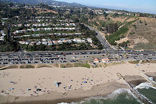
Will Rogers State Beach is a beach park on the Santa Monica Bay, at the Pacific coast of Southern California. Located in the Pacific Palisades neighborhood of Los Angeles, the beach is owned by the California Department of Parks and Recreation; it is managed and maintained by the Los Angeles County Department of Beaches and Harbors.

Rancho Sierra Vista in Ventura County, California, United States, is one of the last intact ranches from the first half of the twentieth century in the Santa Monica Mountains. The majority of the landscape is much as it was 100 years ago. The area is now owned by the Santa Monica Mountains National Recreation Area, a unit of the National Park System.

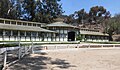
The Will Rogers Polo Club is a polo club in Pacific Palisades, Los Angeles, California. It is located within Will Rogers State Historic Park.

The Palisades Fire is a wildfire burning in the Santa Monica Mountains region of Los Angeles County in Southern California which has killed at least five people. As of January 10, 2025, at 2:33 p.m. PST, the fire had spread to 21,317 acres, destroying the Pacific Palisades neighborhood of Los Angeles and nearby Malibu. It is the first and largest of a series of wildfires being driven by an extremely powerful Santa Ana wind event. On January 8, Wildfire Alliance statistics indicated that the fire is the most destructive fire in Los Angeles history, surpassing the Sayre Fire in Sylmar in 2008 which destroyed 604 structures. The cause of the fire is still under investigation.