
The Los Angeles River, historically known as Paayme Paxaayt by the Tongva and the Río Porciúncula by the Spanish, is a major river in Los Angeles County, California. Its headwaters are in the Simi Hills and Santa Susana Mountains, and it flows nearly 51 miles (82 km) from Canoga Park through the San Fernando Valley, Downtown Los Angeles, and the Gateway Cities to its mouth in Long Beach, where it flows into San Pedro Bay. While the river was once free-flowing and frequently flooding, forming alluvial flood plains along its banks, it is currently notable for flowing through a concrete channel on a fixed course, which was built after a series of devastating floods in the early 20th century.

Downtown Los Angeles (DTLA) is the central business district of Los Angeles. It is part of the Central Los Angeles region and covers a 5.84 sq mi (15.1 km2) area. As of 2020, it contains over 500,000 jobs and has a population of roughly 85,000 residents, with an estimated daytime population of over 200,000 people prior to the COVID-19 pandemic. Despite a business exodus from downtown Los Angeles since the COVID-19 pandemic, the district is evolving as a cultural center with the world's largest showcase of architecture designed by Frank Gehry.

Pacific Palisades is a neighborhood in the Westside region of Los Angeles, California, situated about 20 miles (32 km) west of Downtown Los Angeles.

Studio City is a neighborhood in the city of Los Angeles, California, in the southeast San Fernando Valley, just west of the Cahuenga Pass. It is named after the studio lot that was established in the area by film producer Mack Sennett in 1927, now known as Radford Studio Center.
The Santa Monica Mountains Conservancy is an agency of the state of California in the United States founded in 1980 and dedicated to the acquisition of land for preservation as open space, for wildlife and California native plants habitat Nature Preserves, and for public recreation activities.

The Sepulveda Dam is a dry dam constructed by the U.S. Army Corps of Engineers to withhold winter flood waters along the Los Angeles River. Completed in 1941, at a cost of $6,650,561, it is located south of center in the San Fernando Valley, approximately eight miles (13 km) east of the river's source in the western end of the Valley, in Los Angeles, California.

The Los Angeles Zoo and Botanical Gardens is a 133-acre (54 ha) zoo founded in 1966 and located in Los Angeles, California, United States. The city of Los Angeles owns the zoo, its land and facilities, and the animals.

Glassell Park is a neighborhood of Northeast Los Angeles, California, in the San Rafael Hills.

The Santa Monica Mountains National Recreation Area is a United States national recreation area containing many individual parks and open space preserves, located primarily in the Santa Monica Mountains of Southern California. The SMMNRA is in the greater Los Angeles region, with two thirds of the parklands in northwest Los Angeles County, and the remaining third, including a Simi Hills extension, in southeastern Ventura County.

Elysian Valley, commonly known as Frogtown, is a neighborhood in Central Los Angeles, California, adjoining the Los Angeles River. It has two parks, both maintained by the Mountains Recreation and Conservation Authority (MRCA). The Frogtown Art Walk is a biennial event managed by the Elysian Valley Arts Collective to celebrate local area artists. Knightsbridge Theatre is a repertory theater company located in the neighborhood.

Cypress Park is a densely populated neighborhood of 10,000+ residents in Northeast Los Angeles, California. Surrounded by hills on three sides, it sits in the valley created by the Los Angeles River and the Arroyo Seco. It is the site of the Rio de Los Angeles State Park, the Los Angeles River Bike Path and other recreational facilities. It hosts one private and four public schools.

The Trust for Public Land is a U.S. nonprofit organization with a mission to "create parks and protect land for people, ensuring healthy, livable communities for generations to come". Since its founding in 1972, the Trust for Public Land has completed 5,000 park-creation and land conservation projects across the United States, protected over 3 million acres, and helped pass more than 500 ballot measures—creating $70 billion in voter-approved public funding for parks and open spaces. The Trust for Public Land also researches and publishes authoritative data about parks, open space, conservation finance, and urban climate change adaptation. Headquartered in San Francisco, the organization is among the largest U.S. conservation nonprofits, with approximately 30 field offices across the U.S., including a federal affairs function in Washington, D.C.

Kenneth Hahn State Recreation Area, or Kenneth Hahn Park, is a state park unit of California in the Baldwin Hills Mountains of Los Angeles. The park is managed by the Los Angeles County Department of Parks and Recreation. As one of the largest urban parks and regional open spaces in the Greater Los Angeles Area, many have called it "L.A.'s Central Park". The 401-acre (1.62 km2) park was established in 1984. The land was previously the Baldwin Hills Reservoir, which failed catastrophically in the 1963 Baldwin Hills Dam disaster.
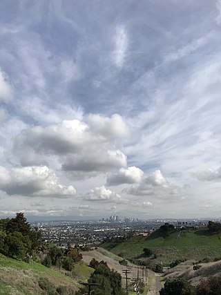
The Baldwin Hills are a low mountain range surrounded by and rising above the Los Angeles Basin plain in central Los Angeles County, California. The Pacific Ocean is to the west, the Santa Monica Mountains to the north, Downtown Los Angeles to the northeast, and the Palos Verdes Hills to the south—with all easily viewed from the Baldwin Hills.

Northeast Los Angeles is a 17.18 sq mi (44.5 km2) region of Los Angeles County, comprising seven neighborhoods within Los Angeles. The area is home to Occidental College located in Eagle Rock.
Franklin Canyon Park is a public municipal park located near Benedict Canyon, at the eastern end of the Santa Monica Mountains, in Los Angeles, California. The park comprises 605 acres (245 ha), and is located near the geographical center of the city of Los Angeles. Franklin Canyon is also the name of the canyon and surrounding neighborhood.
Taylor Yard, in Los Angeles California, United States, is a former railway station and classification yard and headquarters of Southern Pacific Railroad operations in Southern California. The site has been gradually redeveloped with public open space, housing, and other uses including the Rio de Los Angeles State Park. A new Metrolink maintenance facility was built on the southern end of the yard grounds. The site was purchased by the Southern Pacific in 1911 and continually reshaped and remade over the course of the early 20th century for the purposes of inspection, repair, and storage of freight cars on the Southern Pacific Fruit Express line.

Happy Camp Canyon Regional Park is a 3,000-acre (1,200 ha) regional park located in the eastern foothills of Moorpark, California. The park has been run by the Mountains Recreation and Conservation Authority since 1990.

The Vista Hermosa Natural Park is an urban public park located in Echo Park, Los Angeles, immediately west of Civic Center, Los Angeles. Vista Hermosa Natural Park sits on a former oil field of 10.5 acres (4.2 ha), bounded by Toluca Street and West 1st Street, Los Angeles. The park includes walking trails, streams, meadows, oak savannahs, picnic grounds, a nature-themed playground, and a soccer field.


