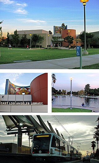
East Los Angeles, or East L.A., is an unincorporated area situated within Los Angeles County, California, United States. According to the United States Census Bureau, East Los Angeles is designated as a census-designated place (CDP) for statistical purposes. The most recent data from the 2020 census reports a population of 118,786, reflecting a 6.1% decrease compared to the 2010 population of 126,496.

Boyle Heights, historically known as Paredón Blanco, is a neighborhood in Los Angeles, California, located east of the Los Angeles River. It is one of the city's most notable and historic Chicano/Mexican-American communities and is known as a bastion of Chicano culture, hosting cultural landmarks like Mariachi Plaza and events like the annual Día de los Muertos celebrations.

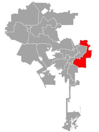
The Eastside is an urban region in Los Angeles County, California. It includes the Los Angeles City neighborhoods east of the Los Angeles River—that is, Boyle Heights, El Sereno, and Lincoln Heights—as well as unincorporated East Los Angeles.

El Sereno is a Los Angeles neighborhood in the Eastside Los Angeles region of Los Angeles County, California.

City Terrace is an unincorporated area of East Los Angeles, in Los Angeles County, California, east of Downtown Los Angeles. It contains City Terrace Elementary School, Robert F. Kennedy Elementary School, Esteban Torres High School, Harrison Elementary School, William R. Anton Elementary School, Hammel Street Elementary School, Anthony Quinn Library, City Terrace Library, and City Terrace Park. It is part of the Census-designated place of East Los Angeles.
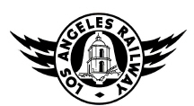
The Los Angeles Railway was a system of streetcars that operated in Central Los Angeles and surrounding neighborhoods between 1895 and 1963. The system provided frequent local services which complemented the Pacific Electric "Red Car" system's largely commuter-based interurban routes. The company carried many more passengers than the Red Cars, which served a larger and sparser area of Los Angeles.

The Sears, Roebuck & Company Mail Order Building is a historic landmark in Boyle Heights, Los Angeles, California. It served as a product distribution center and mail order facility for Sears, Roebuck & Company, with a retail store on the ground floor.
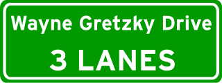
Wayne Gretzky Drive is a freeway in Edmonton, Alberta. Originally Capilano Drive/Capilano Freeway, it was officially renamed October 1, 1999, after NHL hockey player Wayne Gretzky, as a tribute to his years with the Edmonton Oilers. The same day, Wayne Gretzky's number 99 jersey was retired at the Skyreach Centre, which lies just west of Wayne Gretzky Drive, at 118 Avenue. 66/75 Street is a major arterial road in east Edmonton which serves residential and industrial areas.

Cesar Chavez Avenue is a major east–west thoroughfare in Downtown Los Angeles, the Eastside and East Los Angeles, measuring 6.19 miles (9.96 km) in length. Named in honor of union leader César Chávez, the street was formed in 1994 from Sunset Boulevard between Figueroa and Main streets, a new portion of roadway, Macy Street between Main Street and Mission Road, and Brooklyn Avenue through Boyle Heights and East Los Angeles into Monterey Park.

Mariachi Plaza station is an underground light rail station on the E Line of the Los Angeles Metro Rail system. It is located under 1st Street at the intersection of Boyle Avenue, with the main exit located at Mariachi Plaza, after which the station is named. The plaza is the historic gateway to the Boyle Heights neighborhood of Los Angeles. This station opened in 2009 as part of the Gold Line Eastside Extension and was one of two underground stations on the Eastside Extension.

Soto station is an underground light rail station on the E Line of the Los Angeles Metro Rail system. It is located underneath 1st Street at its intersection with Soto Street in the heart of the Boyle Heights neighborhood of Los Angeles. This station opened in 2009 as part of the Gold Line Eastside Extension and was one of two underground stations on the Eastside Extension.

Pico/Aliso station is an at-grade light rail station on the E Line of the Los Angeles Metro Rail system. It is located in the median of East 1st Street between South Anderson Street and South Utah Street in the Boyle Heights neighborhood of Los Angeles. This station opened on November 15, 2009, as part of the Gold Line Eastside Extension.
Los Angeles's 14th City Council district is one of the fifteen districts in the Los Angeles City Council. The district, which has a large Latin American population, includes the neighborhoods of Boyle Heights, Downtown Los Angeles and parts of Northeast Los Angeles. It is currently represented by Democrat Kevin de León since 2020. He replaced José Huizar after winning outright in the special election held during the 2020 California primaries; he was officially appointed on October 15, 2020. Huizar had vacated the seat earlier in the year due to bribery and corruption allegations.

The Sierra Vista Line was a streetcar route mostly operated by the Pacific Electric Railway. It ran from 1895 to 1951 as the short turn making local stops along the Pasadena Short Line on the outside tracks of the Northern Division quadruple-track system.

Rose Hills is a neighborhood on the Eastside of Los Angeles.

Mission Road is a major north-east south-west arterial street in the city of Los Angeles. It serves primarily as an alternative route to get to and from the Downtown Los Angeles area and the San Gabriel Valley. Part of the road is considered a portion of El Camino Real.

Huntington Drive is a major thoroughfare that begins in the Rose Hills community in Los Angeles, California and heads east/northeast to Irwindale, California. The street was named after railroad magnate Henry E. Huntington. It also served as one of the only thoroughfares between Los Angeles and Pasadena in the early 1900s. Portions of Huntington Drive were part of U.S. Route 66. The road has a wide median that was originally one of the lines of the Pacific Electric Railway, the Monrovia–Glendora Line.
Victor Heights, sometimes referred to as the Forgotten Edge, is a neighborhood in Central Los Angeles.