Ocean Avenue (Santa Monica)

Last updated
Ocean Avenue Ocean Avenue.jpg
Ocean Avenue
Ocean Avenue facing northwest Ocean Avenue in Santa Monica.jpg
Ocean Avenue facing northwest

Ocean Avenue is a road in Santa Monica, California.

Contents

Overview

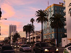
Ocean Avenue starts at the residential Adelaide Drive on the north end of Santa Monica and ends at Pico Boulevard. It is the westernmost street in Santa Monica, and for most of its course it runs parallel to Palisades Park, whose bluffs overlook Pacific Coast Highway and Santa Monica State Beach.

There are several luxury mid-rise and high rise condos with views overlooking the Pacific Ocean, [1] [2] Santa Monica Beach, Malibu, and the Santa Monica Mountains. The Third Street Promenade is two blocks east. The Santa Monica Pier is located at the intersection of Ocean and Colorado. [3]

Many major eastwest arterial roads such as Wilshire Boulevard, Santa Monica Boulevard, and Pico Boulevard begin their western ends on Ocean Avenue. Southeast bound past Pico Boulevard, Ocean turns into Neilson Way. After Neilson Way hits Venice Beach, the street becomes Pacific Avenue, which continues past Washington Boulevard through the Marina Peninsula and ultimately ends at Via Marina and the main channel connecting Marina Del Rey harbor to the Pacific Ocean.

The intersection with California Avenue (the California Incline) leads to Pacific Coast Highway. The Pacific Coast Highway itself crosses underneath Ocean Avenue via the McClure Tunnel.

Notable residents

Related Research Articles

<span class="mw-page-title-main">California State Route 1</span> State highway in California, United States

State Route 1 (SR 1) is a major north–south state highway that runs along most of the Pacific coastline of the U.S. state of California. At 656 miles (1,056 km), it is the longest state route in California, and the second-longest in the US after Montana Highway 200. SR 1 has several portions designated as either Pacific Coast Highway (PCH), Cabrillo Highway, Shoreline Highway, or Coast Highway. Its southern terminus is at Interstate 5 (I-5) near Dana Point in Orange County and its northern terminus is at U.S. Route 101 (US 101) near Leggett in Mendocino County. SR 1 also at times runs concurrently with US 101, most notably through a 54-mile (87 km) stretch in Ventura and Santa Barbara counties, and across the Golden Gate Bridge.

The history of Santa Monica, California, covers the significant events and movements in Santa Monica's past.

<span class="mw-page-title-main">Wilshire Boulevard</span> Major thoroughfare in the metropolitan Los Angeles area, United States

Wilshire Boulevard (['wɪɫ.ʃɚ]) is a prominent 15.83 mi (25.48 km) boulevard in the Los Angeles area of Southern California, extending from Ocean Avenue in the city of Santa Monica east to Grand Avenue in the Financial District of downtown Los Angeles. One of the principal east–west arterial roads of Los Angeles, it is also one of the major city streets through the city of Beverly Hills. Wilshire Boulevard runs roughly parallel to Santa Monica Boulevard from Santa Monica to the west boundary of Beverly Hills. From the east boundary, it runs a block south of Sixth Street to its terminus.

<span class="mw-page-title-main">Sepulveda Boulevard</span> Street in Los Angeles, California

Sepulveda Boulevard is a major street and transportation corridor in the City of Los Angeles and several other cities in western Los Angeles County, California. The street parallels Interstate 405 for much of its route. Portions of Sepulveda Boulevard between Manhattan Beach and Los Angeles International Airport (LAX) are designated as part of State Route 1.

<span class="mw-page-title-main">Marvin Braude Bike Trail</span> Bike path in Los Angeles County, California, United States

The Marvin Braude Bike Trail is a 22-mile (35 km) paved bicycle path that runs mostly along the shoreline of Santa Monica Bay in Los Angeles County, California. The coastal bike trail is widely acknowledged as Los Angeles’ “most popular bike path.”

<span class="mw-page-title-main">California State Route 47</span> Highway in California

State Route 47 is a state highway in the U.S. state of California, connecting Terminal Island to the mainland in the Los Angeles area. From its south end at I-110 in San Pedro, it heads east across the Vincent Thomas Bridge to the island and the end of state maintenance. The state highway begins again at the junction with I-710 on Terminal Island, crossing the Schuyler Heim Bridge north to the mainland and the second terminus, where SR 103 begins. Signage continues along a locally maintained route, mainly Alameda Street, to the Gardena Freeway in Compton, and an unconstructed alignment follows the same corridor to the Santa Monica Freeway (I-10) near downtown Los Angeles.

<span class="mw-page-title-main">Santa Monica Boulevard</span> East-west thoroughfare in Los Angeles, California, United States

Santa Monica Boulevard is a major west–east thoroughfare in Los Angeles County, California, United States. It runs from Ocean Avenue in Santa Monica near the Pacific Ocean to Sunset Boulevard at Sunset Junction in Los Angeles. It passes through Beverly Hills and West Hollywood. A portion of it is designated as California State Route 2.

Pico Boulevard is a major Los Angeles street that runs from the Pacific Ocean at Appian Way in Santa Monica to Central Avenue in Downtown Los Angeles, California, United States. It is named after Pío Pico, the last Mexican governor of Alta California.

<span class="mw-page-title-main">Washington Boulevard (Los Angeles)</span> Road in Los Angeles

Washington Boulevard is an east-west arterial road in Los Angeles County, California spanning a total of 27.4 miles (44 km).

<span class="mw-page-title-main">Western Avenue (Los Angeles)</span> Street in Los Angeles County, California

Western Avenue is a major four-lane street in the city of Los Angeles and through the center portion of Los Angeles County, California. It is one of the longest north–south streets in Los Angeles city and county, apart from Sepulveda Boulevard. It is about 29 miles (47 km) long.

<span class="mw-page-title-main">Vermont Avenue</span> Major thoroughfare in Los Angeles, CA

Vermont Avenue is one of the longest running north–south streets in City of Los Angeles and Los Angeles County, California. With a length of 23.3 miles (37.5 km), is the third longest of the north–south thoroughfares in the region. For most of its length between its southern end in San Pedro and south of Downtown Los Angeles, it runs parallel to the west of the Harbor Freeway (I-110).

The western border of Santa Monica, California, is the 3-mile (4.8 km) stretch of Santa Monica Bay. On its other sides, the city is bordered by various districts of Los Angeles: the northwestern border is Pacific Palisades, the eastern border is Brentwood north of Wilshire Boulevard and West Los Angeles south of Wilshire, the northeastern border is generally San Vicente Boulevard up to the Riviera Country Club, the southwestern border is Venice Beach and the southern border is with West Los Angeles and Mar Vista.

<span class="mw-page-title-main">Atlantic Boulevard (Los Angeles County)</span>

Atlantic Boulevard/Atlantic Avenue/Los Robles Avenue is a major north–south thoroughfare in eastern Los Angeles County, California.

<span class="mw-page-title-main">California county routes in zone N</span>

There are 9 routes assigned to the "N" zone of the California Route Marker Program, which designates county routes in California. The "N" zone includes county highways lying in Los Angeles and Orange counties.

<span class="mw-page-title-main">Venice Short Line</span> Los Angeles streetcar route (1897-1950)

The Venice Short Line was a Pacific Electric (PE) interurban railway line in Los Angeles which traveled from downtown Los Angeles to Venice, Ocean Park, and Santa Monica via Venice Boulevard. The route was especially busy on Sundays, as Venice was PE's most popular beachfront destination.

<span class="mw-page-title-main">McClure Tunnel</span> Tunnel in California

The McClure Tunnel is a tunnel in Santa Monica, California, that connects Pacific Coast Highway to its junction with the western terminus of the Santa Monica Freeway. The tunnel passes through the Santa Monica ocean bluffs, underneath the Colorado Avenue–Ocean Avenue intersection and close to the Santa Monica Pier and southern end of Palisades Park. The length of the McClure Tunnel is about 400 feet (120 m). The current tunnel opened in 1936, replacing an earlier rail tunnel which had been bored in 1886. It was officially named the McClure Tunnel in 1979 after Robert E. McClure, a local newspaper publisher and member of the state highway commission.

<span class="mw-page-title-main">Santa Monica Army Air Forces Redistribution Center</span> World War II complex in Santa Monica, California

Santa Monica Army Air Forces Redistribution Center or Redistribution Station No.3 was a complex of buildings and hotels located in Santa Monica, California used to house troops during and after World War 2. US Army Air Force picked the Santa Monica site as Douglas Aircraft Company has a large Aerospace manufacturer operated there at Clover Field, also called Santa Monica Army Air Base). Opened in November 1943, the Redistribution opened out of leased buildings and land, most on what is now the Santa Monica State Beach. Crews rotation from Europe war and the Pacific war were able to rest and relax before their next assignment. At its peak, the complex covered 65 acres and had a staff of 1,200. Many of the staff at the center were from the Women's Army Corps. Organized social events were put on by the Santa Monica-Ocean Park chapter of the American Red Cross. At the end of the war, the complex became a processing center for troops heading home. Over 35,000 airmen had been processed at the center. Next, the complex processed prisoners of war heading home. The complex was deactivated on 15 November 1945 and the last leased building was closed in January 1947. Most of the buildings are in what is called Ocean Park, California on Ocean Avenue. The Army Air Force operated other Redistribution Centers in Atlantic City, Miami, San Antonio, Greensboro and Santa Ana, California at Camp Davis.

<span class="mw-page-title-main">Ocean Park, Santa Monica</span> Neighborhood in Los Angeles, California, United States

Ocean Park is a Santa Monica neighborhood of Santa Monica, California within the Westside region of Los Angeles County, California, United States.

<span class="mw-page-title-main">Akshata Murty</span> Indian businesswoman (born 1980)

Akshata Narayana Murty is an Indian heiress, businesswoman, fashion designer, and venture capitalist. She is married to Rishi Sunak, the Prime Minister of the United Kingdom and leader of the Conservative Party. According to the Sunday Times Rich List, Murty and Sunak hold the 275th rank for the richest people in Britain as of 2023, with a combined wealth of £529 million.

References

  1. "101 Ocean Condos Santa Monica | 101 Ocean Ave". www.toplacondos.com. Retrieved 2021-05-02.
  2. "1221 Ocean Avenue Luxury Apartments in Santa Monica". Ocean Avenue. Retrieved 2021-05-02.
  3. "Santa Monica Pier | Santa Monica Pier Parking, Directions & Info". Visit Santa Monica. Retrieved 2021-05-02.
  4. "Inside the Fortune of Britain's New Prime Minister Rishi Sunak and His Wife, Akshata Murthy". Forbes . Retrieved 25 October 2022.