Related Research Articles

Alhambra is a city located in the western San Gabriel Valley region of Los Angeles County, California, United States, approximately eight miles from the Downtown Los Angeles civic center. It was incorporated on July 11, 1903. As of the 2020 census, the population was 82,868. The city's ZIP Codes are 91801 and 91803.
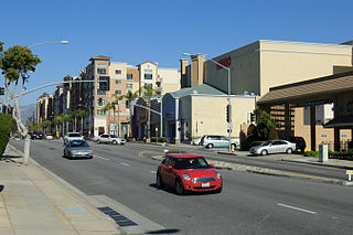
Monterey Park is a city in the western San Gabriel Valley region of Los Angeles County, California, United States, approximately seven miles (11 km) east of the Downtown Los Angeles civic center. It is bordered by Alhambra, East Los Angeles, Montebello and Rosemead. The city's motto is "Pride in the past, Faith in the future".

Rosemead is a city in Los Angeles County, California, United States. The 2020 United States Census reported a population of 51,185. Rosemead is part of a cluster of cities, along with Alhambra, Arcadia, Temple City, Monterey Park, San Marino, and San Gabriel, in the west San Gabriel Valley with a growing Asian-American population.

The San Gabriel Valley, often referred to by its initials as SGV, is one of the principal valleys of Southern California, with the city of Los Angeles directly bordering it to the west, and occupying the vast majority of the southeastern part of Los Angeles County. Surrounding landforms and other features include the following:

Route 710, consisting of the non-contiguous segments of State Route 710 (SR 710) and Interstate 710 (I-710), is a major north–south state highway and auxiliary Interstate Highway in the Los Angeles metropolitan area of the U.S. state of California. Also called the Los Angeles River Freeway prior to November 18, 1954, the highway was initially planned to connect Long Beach and Pasadena, but a gap in the route exists from Alhambra to Pasadena through South Pasadena due to community opposition to its construction.

Sam Woo Restaurant (三和) is a restaurant chain that serves Hong Kong–style cuisine. It has many locations in predominantly overseas Chinese communities of Southern California, in Las Vegas, and in the suburbs of Toronto. "Sam Woo" is a romanization of the Cantonese pronunciation for "triple harmonies," in reference to feng shui principles, including the synthesis of heaven, earth, and humanity. The complete Chinese name (三和燒臘麵家) would translate literally into English as "Three Harmonies Roast Meats and Noodle House."
The San Gabriel Valley Tribune is a paid daily newspaper located in Monrovia, California, that serves the central and eastern San Gabriel Valley. It operated at the West Covina location from 1955 to 2015. The Tribune is a member of Southern California News Group, a division of Digital First Media. It is also part of the San Gabriel Valley Newspaper Group, along with the Pasadena Star-News and the Whittier Daily News.

State Route 39 is a state highway in the U.S. state of California that travels through Orange and Los Angeles counties. Its southern terminus is at Pacific Coast Highway, in Huntington Beach. SR 39's northern terminus is at Islip Saddle on Angeles Crest Highway in the Angeles National Forest, but its northernmost 4.5-mile (7.2 km) segment has been closed to public highway traffic since 1978 due to a massive mud and rockslide.

University Hills is a neighborhood on the East Side of Los Angeles, California. It consists of the residential areas surrounding California State University, Los Angeles.

The Asian-American influx to the San Gabriel Valley grew rapidly when Chinese began settling in Monterey Park, California, in the western San Gabriel Valley in the 1970s. Just east of Los Angeles, the region has achieved international prominence as a hub of overseas Chinese, or hua qiao. Although Chinese immigrants were a noteworthy presence in the establishment of Southern California from the 19th century, significant Chinese migration to suburban San Gabriel Valley coincided with a trend of white out-migration from the 1970s onward. This opened an opportunity for middle-class Asian Americans to begin settling in the San Gabriel Valley.
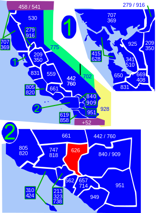
Area code 626 is a telephone area code in the North American Numbering Plan for most of the San Gabriel Valley in the U.S. state of California. The numbering plan area also comprises nearby areas in the northeastern portion of Los Angeles County, California, including Arcadia, Monrovia, El Monte, most of Pasadena and West Covina. The numbering plan area was split from that of area code 818 on June 14, 1997.
The San Gabriel Pastoral Region is a pastoral region of the Archdiocese of Los Angeles in the Roman Catholic Church. It covers East Los Angeles through the San Gabriel and Pomona valleys. The region has 67 parishes, 13 high schools, many elementary schools, no hospitals, 2 cemeteries, and 1 Spanish Mission. Bishop Brian Nunes currently serves as Episcopal Vicar for the San Gabriel Pastoral Region.
Interstate 10 (I-10) is a transcontinental Interstate Highway in the United States, stretching from Santa Monica, California, to Jacksonville, Florida. The segment of I-10 in California, also known as the Pearl Harbor Memorial Highway, runs east from Santa Monica through Los Angeles, San Bernardino, and Palm Springs before crossing into the state of Arizona. In the Greater Los Angeles area, it is known as the Santa Monica and San Bernardino freeways, linked by a short concurrency on I-5 at the East Los Angeles Interchange. I-10 also has parts designated as the Rosa Parks and Sonny Bono Memorial freeways. Some parts were also formerly designated as the Christopher Columbus Transcontinental Highway. However, the California State Legislature removed this designation following the passage of a bill on August 31, 2022. I-10 is also known colloquially as "the 10" to Southern California residents .
Valley Boulevard is a street in Southern California, running east from Los Angeles to Pomona, where it becomes Holt Avenue, and a continuation from Fontana to Colton. It generally parallels Interstate 10 (I-10) and State Route 60 (CA 60), and is the original alignment of U.S. Route 60 (US 60). The present north end of I-710 is at Valley Boulevard in Los Angeles, just west of Alhambra.
Law enforcement in Los Angeles County is conducted by a variety of law enforcement agencies.
Garvey School District is a pre-K-8 school district with headquarters located in the city of Rosemead, California. It operates nine pre-K-6 elementary schools, one pre-K-8 elementary school and two intermediate schools. The district serves more than 6000 students from diverse backgrounds, predominantly Asian and Latin American.

Garfield Avenue ' is a major north-south street in Los Angeles County, California, US.

The Upland–San Bernardino Line was an interurban line operated by the Pacific Electric Railway between Downtown Los Angeles and San Bernardino, California. This line also had shorter service that terminated before the end of the line at Baldwin Park, Covina, and San Dimas. Though service along this line in its entirety was discontinued in November 1941, it stands as the fourth-longest rapid transit line in American history, after the Sacramento Northern Chico and Colusa services, and the Pacific Electric's own Riverside–Rialto Line.

Susan Rubio is an American politician serving in the California State Senate. She represents the 22nd Senate District in eastern Los Angeles County and is a member of the Democratic Party. Prior to being elected to the California Legislature in 2018, she was an elected official for the City of Baldwin Park for 13 years and a public school teacher for 17 years.
References
- ↑ Sonksen, Mike. "Garvey Avenue from Alhambra to El Monte". KCET . Retrieved 22 June 2019.
- ↑ Nathan Landau. Car-Free Los Angeles and Southern California. p. 94.