Sunland Boulevard is a major thoroughfare in the Crescenta and San Fernando Valleys.
Sunland Boulevard is a major thoroughfare in the Crescenta and San Fernando Valleys.
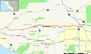
Sunland Boulevard splits off of Foothill Boulevard in the Sunland area of the Crescenta Valley. It runs for about 5 miles (8 kilometers) before changing to Vineland Avenue directly south of San Fernando Road in Sun Valley. It also crosses intersection with Interstate 210 near its northern terminus and Interstate 5 near its southern terminus.
Sunland Boulevard is served by Metro Local line 90.
La Crescenta-Montrose is an unincorporated area in Los Angeles County, California, United States. The community is bordered by Glendale to the south and west, La Cañada Flintridge to the east, and Angeles National Forest to the north. According to the United States Census Bureau, the La Crescenta-Montrose CDP measures about 3.4 square miles (8.8 km2), and the population was 19,653 at the 2010 census, up from 18,532 in 2000.

The San Fernando Valley, known locally as The Valley, is an urbanized valley in Los Angeles County, California. Located just north of the Los Angeles Basin, the valley incorporates part of the City of Los Angeles, as well as the incorporated cities of Burbank and San Fernando. The valley is well known for its iconic film studios such as Warner Bros. Studio and Walt Disney Studios. In addition, it is home to the Universal Studios Hollywood theme park.

The Ventura Freeway is a freeway in southern California, United States, running from the Santa Barbara/Ventura county line to Pasadena in Los Angeles County. It is the principal east-west route through Ventura County and in the southern San Fernando Valley in Los Angeles County. From the Santa Barbara County line to its intersection with the Hollywood Freeway in the southeastern San Fernando Valley in Los Angeles, it is signed as U.S. Route 101 (US 101), which was built in the late 1950s and opened on April 5, 1960. East of the Hollywood Freeway intersection, it is signed as State Route 134 (SR 134) which was built by 1971.
State Route 118 is a state highway in the U.S. state of California that runs west to east through Ventura and Los Angeles counties. It travels from State Route 126 at the eastern edge of Ventura immediately northwest of Saticoy, then through Saticoy, in Ventura County east to Interstate 210 near Lake View Terrace in Los Angeles. SR 118 crosses the Santa Susana Pass and the northern rim of the San Fernando Valley along its route.

The Southern California freeways are a vast network of interconnected freeways in the megaregion of Southern California, serving a population of 23 million people. The Master Plan of Metropolitan Los Angeles Freeways was adopted by the Regional Planning Commission in 1947 and construction began in the early 1950s. The plan hit opposition and funding limitations in the 1970s, and by 2004, only some 61% of the original planned network had been completed.
The Foothill Freeway is a freeway in the Los Angeles metropolitan area of the U.S. state of California, running from the Sylmar district of Los Angeles east to Redlands. The western segment is signed as Interstate 210 (I-210) from its western end at Interstate 5 (I-5) to State Route 57 (SR 57) in Glendora, while the eastern segment is signed as State Route 210 (SR 210) to its eastern terminus at Interstate 10 (I-10). Under the California Streets and Highways Code, the entire Foothill Freeway is legally referred to as Route 210.

The Crescenta Valley is a small inland valley in Los Angeles County, California, lying between the San Gabriel Mountains on the northeast and the Verdugo Mountains and San Rafael Hills on the southwest. It opens into the San Fernando Valley at the northwest and the San Gabriel Valley at the southeast. It is nearly bisected by the Verdugo Wash, a smaller valley separating the Verdugo Mountains from the San Rafael Hills. Most of the valley lies at an elevation of over 1,500 feet.

The Verdugo Mountains, also known as the Verdugo Hills or simply The Verdugos, are a small, rugged mountain range of the Transverse Ranges system in Los Angeles County, California. Located just south of the western San Gabriel Mountains, the Verdugo Mountains region incorporates the cities of Glendale, Pasadena, and La Cañada Flintridge; the unincorporated communities of Altadena and La Crescenta-Montrose; as well as the City of Los Angeles neighborhood of Sunland-Tujunga.

Sepulveda Boulevard is a major street and transportation corridor in the City of Los Angeles and several other cities in western Los Angeles County, California. It is around 42.8 miles (68.9 km) in length, making it the longest street in the city and county of Los Angeles and parallels Interstate 405 for much of its route.

Shadow Hills is a neighborhood in the Verdugo Mountains and northeastern San Fernando Valley, within the city of Los Angeles, California.

Western Avenue is a major four-lane street in the city of Los Angeles and through the center portion of Los Angeles County, California. It is one of the longest north–south streets in Los Angeles city and county, apart from Sepulveda Boulevard. It is about 29 miles (47 km) long.

Laurel Canyon Boulevard is a major street in the city of Los Angeles. It starts off at Polk Street in Sylmar in the northern San Fernando Valley near the junction of the San Diego and the Golden State (I-5)) freeways. Laurel Canyon Boulevard bypasses the city of San Fernando to the west, running parallel to I-5 in the vicinity of Pacoima and Arleta. The portion through Sun Valley passes through rock quarries and a great deal of open space.

San Fernando Road is a major street in the City of Los Angeles and Los Angeles County. Within the Burbank city limits it is signed as San Fernando Boulevard, and north of Newhall Pass it is signed as The Old Road. It was previously designated as Business Loop 5 in the 1970s.
Foothill Boulevard is a major road in the city and county of Los Angeles, as well as an arterial road in the city and county of San Bernardino, stretching well over 60 miles (97 km) in length, with some notable breaks along the route. Like its name implies, Foothill Boulevard runs across the foothills of the San Gabriel and San Bernardino Mountains.

Verdugo Wash is a 9.4-mile-long (15.1 km) tributary of the Los Angeles River, in the Glendale area of Los Angeles County, California.

Burbank Western Channel is a 6.3-mile-long (10.1 km) tributary of the Los Angeles River in the eastern San Fernando Valley of Los Angeles County, California.
Los Angeles City Council District 2 is one of the 15 districts of the Los Angeles City Council. The 2nd District began its existence in the Hollywood area but now covers much of the far eastern and southeastern portions of the San Fernando Valley and parts of the Crescenta Valley. The current representative is Paul Krekorian.
Glenoaks Boulevard is a major thoroughfare in Los Angeles County, which stretches some 22.4 miles as a north-south thoroughfare in Sylmar at its intersection with Foothill Boulevard to a west-east thoroughfare in Glendale before ending in the Scholl Canyon area as a minor street. It passes through much of the San Fernando Valley including San Fernando, Pacoima, and Sun Valley. It is also a north-south thoroughfare in Burbank. Glenoaks Boulevard runs east of and parallel to Interstate 5 in San Fernando and Burbank, and north of and parallel to State Route 134 in Glendale.
Vineland Avenue is a major north-south thoroughfare in the San Fernando Valley.

Sunland-Tujunga is a Los Angeles City neighborhood within the San Fernando Valley and Verdugo Mountains. Sunland and Tujunga began as separate settlements and today are linked through a single police station, branch library, neighborhood council, chamber of commerce, city council district, and high school. The merging of these communities under a hyphenated name goes back as far as 1928. Sunland-Tujunga contains the highest point of the city, Mount Lukens.