
Leimert Park is a neighborhood in the South Los Angeles region of Los Angeles, California.

Crenshaw, or the Crenshaw District, is a neighborhood in South Los Angeles, California.

Jefferson Park is a neighborhood in the South Los Angeles region of the City of Los Angeles, California. There are fourteen Los Angeles Historic-Cultural Monuments in the neighborhood, and in 1987, the 1923 Spanish Colonial Revival Jefferson Branch Library was added to the National Register of Historic Places. A portion of the neighborhood is a designated Historic Preservation Overlay Zone (HPOZ).

Sepulveda Boulevard is a major street and transportation corridor in the City of Los Angeles and several other cities in western Los Angeles County, California. The street parallels Interstate 405 for much of its route. Portions of Sepulveda Boulevard between Manhattan Beach and Los Angeles International Airport (LAX) are designated as part of State Route 1.

Slauson Avenue is a major east–west thoroughfare traversing the central part of Los Angeles County, California. It was named for the land developer and Los Angeles Board of Education member J. S. Slauson. It passes through Culver City, Ladera Heights, View Park-Windsor Hills, South Los Angeles, Huntington Park, Maywood, Commerce, Montebello, Pico Rivera, Whittier, and Santa Fe Springs. The street runs 20.9 miles (33.6 km) from McDonald Street in Culver City and to Santa Fe Springs Road, where it becomes Mulberry Drive in Whittier. Mulberry Drive ends at Scott Avenue in South Whittier.

Hyde Park is a neighborhood in the South region of Los Angeles, California. Formerly a separate city, it was consolidated with Los Angeles in 1923.

37th Street/USC station is a busway station located in Los Angeles, California. It is situated between the LATTC/Ortho Institute and Slauson stations on the J Line, a bus rapid transit route which runs between El Monte, Downtown Los Angeles and San Pedro as part of the Metro Busway system. The station consists of two side platforms in the center of Interstate 110 above 37th Street, adjacent to the University of Southern California campus. The station serves the University Park, Exposition Park and Historic South Central neighborhoods of Los Angeles.
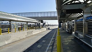
Slauson station is a busway station located in Los Angeles, California. It is situated between the 37th Street/USC and Manchester stations on the J Line, a bus rapid transit route which runs between El Monte, Downtown Los Angeles and San Pedro as part of the Metro Busway system. The station consists of two side platforms in the center of Interstate 110 above Slauson Avenue. The station serves the Vermont-Slauson, South Park and Florence neighborhoods of Los Angeles.

The K Line is a 5.9-mile (9.5 km) light rail line running north–south between the Jefferson Park and Westchester neighborhoods of Los Angeles, California, passing through various South Los Angeles neighborhoods and the city of Inglewood. It is one of six lines in the Los Angeles Metro Rail system operated by the Los Angeles County Metropolitan Transportation Authority (LACMTA). It opened on October 7, 2022, making it the system's newest line.
This article covers streets in Los Angeles, California between and including 41st Street and 250th Street. Major streets have their own linked articles; minor streets are discussed here.

South Los Angeles, also known as South Central Los Angeles or simply South Central, is a region in southwestern Los Angeles County, California, lying mostly within the city limits of Los Angeles, south of downtown. It is "defined on Los Angeles city maps as a 16-square-mile (41 km2) rectangle with two prongs at the south end.” In 2003, the Los Angeles City Council renamed this area "South Los Angeles".

Ermias Joseph Asghedom, known professionally as Nipsey Hussle, was an American rapper, entrepreneur, and activist. Emerging from the West Coast hip hop scene in the mid-2000s, Hussle independently released his debut mixtape, Slauson Boy Volume 1, to moderate local success, which led to him being signed to Cinematic Music Group and Epic Records.

5 or the 5 Car was a streetcar line operated by the Los Angeles Railway, later named as the Los Angeles Transit Lines, by the Los Angeles Metropolitan Transit Authority. From 1920 to 1932, this route was known as the E Car. This was changed as part of a method to distinguish routes that lacked loops at their termini. Consequently, the 5 Car was unique during the LAMTA era in that it did not use PCC streetcars. It used buses from 1955 to 1964, transferring from LATL in 1958, then splitting the line in two in 1961, until all lines were turned over to SCRTD in August 1964.

Martin Luther King Jr. station is an underground light rail station on the K Line of the Los Angeles Metro Rail system. It is located underneath Crenshaw Boulevard at its intersection with Martin Luther King Jr. Boulevard, after which the station is named, in the Los Angeles neighborhoods of Baldwin Hills and Leimert Park. The station’s main entrance is next to the iconic Baldwin Hills Crenshaw Plaza shopping mall.

Leimert Park station is an underground light rail station on the K Line of the Los Angeles Metro Rail system. It is located underneath Crenshaw Boulevard at its intersection with Vernon Avenue in the Leimert Park neighborhood of Los Angeles.
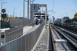
Hyde Park station is an at-grade light rail station on the K Line of the Los Angeles Metro Rail system. It is located in the median of Crenshaw Boulevard between its intersections with Slauson Avenue and 59th Street in the Hyde Park neighborhood of Los Angeles.

The K Line Northern Extension, formerly known as the Crenshaw Northern Extension, is a project planning a Los Angeles Metro Rail light rail transit corridor extension connecting Expo/Crenshaw station to Hollywood/Highland station in Hollywood. The corridor is a fully underground, north-south route along mostly densely populated areas on the western side of the Los Angeles Basin; it would be operated as part of the K Line. The Los Angeles County Metropolitan Transportation Authority (Metro) is prioritizing the project along with pressure from the West Hollywood residents. Construction is slated to start in 2041 and begin service by 2047 unless means to accelerate the project are found.

Destination Crenshaw is an under-construction 1.3-mile-long (2.1 km) open-air museum along Crenshaw Boulevard in Los Angeles, California, dedicated to preserving the history and culture of African Americans. The project includes new pocket parks, outdoor sculptures, murals, street furniture, and landscaping.

