Sunset Boulevard

Last updated

Sunset Boulevard
Sunsetblvdnearvine.jpg
Sunset Boulevard near Vine Street in Hollywood
Sunset Boulevard.png
Location
Nearest metro station LAMetroLogo.svg LACMTA Circle B Line.svg   Vermont/Sunset
West endCalifornia 1.svg SR 1 (Pacific Coast Highway) in Pacific Palisades
Major
junctions
I-405 (1961).svg I-405 in Brentwood
US 101 (1961 cutout).svg US 101 in Hollywood
California 2.svg SR 2 in Echo Park
East endCalifornia 110.svg SR 110/Figueroa Street in Downtown Los Angeles
Signs along the Sunset Strip Sunsetblvd.jpg
Signs along the Sunset Strip
Sunset Blvd at the West Gate of Bel Air Belair.jpg
Sunset Blvd at the West Gate of Bel Air
Emerson College Los Angeles Center at 5960 Sunset Blvd Emerson College Los Angeles.png
Emerson College Los Angeles Center at 5960 Sunset Blvd

Sunset Boulevard is a boulevard in the central and western part of Los Angeles, California, United States, that stretches from the Pacific Coast Highway in Pacific Palisades east to Figueroa Street in Downtown Los Angeles. It is a major thoroughfare in the cities of Beverly Hills and West Hollywood (including a portion known as the Sunset Strip), as well as several districts in Los Angeles.

Contents

Geography

Approximately 23.6 miles (38 km) in length, [1] the boulevard roughly traces the arc of mountains that form part of the northern boundary of the Los Angeles Basin, following the path of a 1780s cattle trail from the Pueblo de Los Angeles to the ocean. [2]

From Downtown Los Angeles, the boulevard heads northwest, to Hollywood, through which it travels due west for several miles before it bends southwest towards the ocean. It passes through or near Echo Park, Silver Lake, Los Feliz, Hollywood, West Hollywood, Beverly Hills, and Holmby Hills. In Bel-Air, Sunset Boulevard runs along the northern boundary of UCLA's Westwood campus. The boulevard continues through Brentwood to Pacific Palisades, where it terminates at the Pacific Coast Highway intersection.

The boulevard has curvaceous winding stretches, and can be treacherous for unalert drivers in some sections. Sunset Boulevard is at least four lanes wide along its entire route. Sunset is frequently congested with traffic loads beyond its design capacity.

Sunset Boulevard historically extended farther east than it does now, starting at Alameda Street near Union Station and beside Olvera Street in the historic section of Downtown. The portion of Sunset Boulevard east of Figueroa Street was renamed Cesar Chavez Avenue [1] in 1994, along with Macy Street and Brooklyn Avenue, in honor of the late Mexican-American union leader and civil rights activist.

History

In 1877, Harvey Henderson Wilcox, one of the earlier real estate owners from "back East", decided to subdivide more than 20 acres (8.1 ha) of land (mostly orchards and vineyards) along Sunset Boulevard, including what is today Hollywood and Vine. [3]

In 1890, Belgian diplomat Victor Ponet bought 240 acres (97 ha) of the former Rancho La Brea land grant. [4] His son-in-law, Francis S. Montgomery, inherited this property and created Sunset Plaza. [5] [ irrelevant citation ]

According to a 1901 article in the Los Angeles Herald , Sunset only extended from Hollywood in the west to Marion Avenue in the Echo Park district in the east. [6] The Board of Public Works proposed to extend Sunset east to Main Street in the Plaza by routing the road over the existing section of Bellevue Avenue, [7] but the plan was delayed until approximately 1904, [8] [9] due to active opposition by affected land owners. [10] According to the 1910 [11] Baist Real Estate Survey Atlas, Sunset Boulevard reached the Plaza by that time, but it did so by two short and narrow segments which were not aligned with each other and thus did not provide a proper thoroughfare to it. In late 1912, several properties along the route were condemned so that the boulevard could be changed in both its width and its alignment. [12] [13] With these changes completed, Sunset Boulevard now reached North Main Street and continued as Marchessault along the northern end of the Plaza. This section, variously marked and signed as Marchessault Street or East Sunset Boulevard, remained open to traffic until the late 1960s or early 1970s. [14] At that time, Sunset was realigned one block north and Marchessault was closed to motor traffic.

In 1921 a westward expansion of Sunset began, extending the road from the then-current terminus at Sullivan Canyon toward the coast. This land, a portion of the original 1838 holdings of Francisco Marquez, stretched across a mesa and became known as the "Riviera section". Will Rogers, who had bought much of this land as an investment, later donated it to the State of California creating Will Rogers State Historic Park. [15] c.1931, Sunset was a paved road from Horn Avenue to Havenhurst Avenue. [16]

Cultural aspects

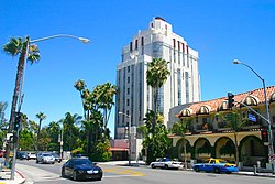
The Sunset Strip portion of Sunset Boulevard in West Hollywood has been famous for its active nightlife since at least the 1950s. [17]

In contrast to other American cities where it referred to a concentration of radio retailers, in Los Angeles, Radio Row was understood in the 1940s–1950s as the area around the intersection of Sunset Boulevard and Vine Street in Hollywood, where the broadcasting facilities of all four major radio networks were located. [18]

In the 1970s, the area between Gardner Street and Western Avenue was a center for street prostitution. [19] Shortly after a much publicized incident in late June 1995, police raids drove out the majority of prostitutes on the Boulevard.

Part of Sunset Boulevard in Hollywood is also sometimes called "Guitar Row" due to the large number of guitar stores and music industry-related businesses, [20] including the recording studios Sunset Sound Studios and United Western Recorders.

The portion of Sunset Boulevard that passes through Beverly Hills was once named Beverly Boulevard.

The boulevard is commemorated in Billy Wilder's film Sunset Boulevard (1950), the Andrew Lloyd Webber musical of the same name, and the 1950s television series 77 Sunset Strip . Jan and Dean's 1960s hit song "Dead Man's Curve" refers to a section of the road near Bel Air estates just north of UCLA's Drake Stadium where Jan Berry almost died in an automobile accident in 1966. [21] The Buffalo Springfield song "For What It's Worth" was written about a riot at Pandora's Box, a Sunset Strip club, in 1966. [22]

Metro Local lines 2, 4 and 602 operate on Sunset Boulevard, with Line 2 running through most of Sunset Boulevard between Echo Park and UCLA, Line 4 between Sunset Junction and Downtown LA, and Line 602 from UCLA west. The Metro B Line operates a subway station at Vermont Avenue.

At 4334 W. Sunset Boulevard lies the wall featured on the cover of the late singer-songwriter Elliott Smith's 2000 album Figure 8. Since Smith's death in 2003, the wall has become a memorial for the artist; fans have left many personal messages there over the years.

Landmarks (past and present)

See also

Notes

  1. 1 2 Feiler, Bruce (September 21, 2010). America's Prophet: How the Story of Moses Shaped America. HarperCollins. p. 208. ISBN   978-0-06-172627-9 . Retrieved August 9, 2012.
  2. Hawthorne, Christopher (July 14, 2012). "For Sunset, a new dawn". Los Angeles Times. Retrieved August 9, 2012.
  3. Kennelley 1981, p. 69.
  4. Kennelley 1981, p. 165.
  5. McGroarty, John Steven (1921). Los Angeles from the Mountains to the Sea: With Selected Biography of Actors and Witnesses to the Period of Growth and Achievement, Volume 3. American Historical Society. p. 891. OCLC   920607532.
  6. "Board Acts With Favor: Sunset Boulevard May Be Extended: Proposed Improvement Will Cost Hundred Thousand Dollars: Estimates Are Presented to Board of Public Works by Fred Eaton and That Body Grants Petition, for Its Extension—Cost of Widening Bellevue Avenue to a Point Near Plaza". Los Angeles Herald . Vol. 28, no. 4. October 5, 1901. p. 9 via California Digital Newspaper Collection. Sunset boulevard at present extends from Hollywood, in the beautiful Cahuenga valley, to Marion avenue. It is now proposed to make Bellevue avenue an extension of the system from Marion avenue to Main street. In order to make the driveway a uniform width It will be necessary to widen Bellevue avenue from seventeen to twenty feet in many places between Marion avenue and the plaza.
  7. "Sunset Boulevard May Reach Plaza: City Councilmen Encourage The Extensive Project. Committee of Business Men Secures Favorable Action from the Board of Public Works" . Los Angeles Times . October 5, 1901. p. A2. Alternate Link via ProQuest.
  8. "New Boulevard Is Completed: Suburban Residents Will Celebrate Saturday". Los Angeles Herald . Vol. 31, no. 227. May 13, 1904. p. 12 via California Digital Newspaper Collection.
  9. "Los Angeles And Hollywood Unite In Opening Of Sunset Boulevard". Los Angeles Herald . Vol. 31, no. 229. May 15, 1904. p. 5 via California Digital Newspaper Collection.
  10. "Protest Against Improvement". Los Angeles Herald . Vol. 29, no. 315. August 14, 1902. p. 6 via California Digital Newspaper Collection.
  11. 1910 Baist Real Estate Survey Atlas, Los Angeles. Plate 003 (Map). Philadelphia: G. W. Baist. 1910. OCLC   19764849.
  12. "Old-day Buildings to Go for Street" . Los Angeles Times . September 17, 1912. p. I7. Alternate Link via ProQuest.
  13. Baist Real Estate Survey Atlas, Los Angeles. Plate 003 (Map). Philadelphia: G. W. Baist. 1914.
  14. More research is needed to pin down the year
  15. Kennelley 1981, p. 219-221.
  16. Kennelley 1981, p. 182.
  17. Starr, Kevin (February 14, 2006). Coast of Dreams. Random House. p. 455. ISBN   978-0-679-74072-8 . Retrieved August 9, 2012.
  18. "11 Aug 2005, Page 10 - The Los Angeles Times at Newspapers.com". Newspapers.com.
  19. Ditmore, Melissa Hope (August 30, 2006). Encyclopedia of Prostitution and Sex Work. Greenwood Publishing Group. p. 260. ISBN   978-0-313-32968-5 . Retrieved August 9, 2012.
  20. Green, Frank W. M. (March 5, 2008). D'Angelico, Master Guitar Builder: What's in a Name?. Hal Leonard Corporation. p. 69. ISBN   978-1-57424-217-1 . Retrieved August 9, 2012.
  21. Warshaw, Matt (September 1, 2010). The History of Surfing. Chronicle Books. p. 198. ISBN   978-0-8118-5600-3 . Retrieved August 9, 2012.
  22. Rasmussen, Cecilia (August 5, 2007). "Closing of club ignited the 'Sunset Strip riots'". Los Angeles Times. Retrieved August 9, 2012.

Related Research Articles

<span class="mw-page-title-main">Hollywood, Los Angeles</span> Neighborhood in Los Angeles, California, US

Hollywood is a neighborhood in the central region of Los Angeles County, California, mostly within the city of Los Angeles. Its name has come to be a shorthand reference for the U.S. film industry and the people associated with it. Many notable film studios, such as Sony Pictures, Walt Disney Studios, Paramount Pictures, Warner Bros. and Universal Pictures, are located near or in Hollywood.

<span class="mw-page-title-main">Westwood, Los Angeles</span> Neighborhood of Los Angeles in California, United States

Westwood is a commercial and residential neighborhood in the northern central portion of the Westside region of Los Angeles, California. It is the home of the University of California, Los Angeles (UCLA). Bordering the campus on the south is Westwood Village, a major regional district for shopping, dining, movie theaters, and other entertainment.

<span class="mw-page-title-main">Bel Air, Los Angeles</span> Neighborhood of Los Angeles, California

Bel Air is a residential neighborhood on the Los Angeles Westside, in the foothills of the Santa Monica Mountains in the U.S. state of California. Founded in 1923, it is the home of the Hannah Carter Japanese Garden and the American Jewish University.

<span class="mw-page-title-main">Pacific Palisades, Los Angeles</span> Neighborhood in California, US

Pacific Palisades is a neighborhood in the Westside region of Los Angeles, California, situated about 20 miles (32 km) west of Downtown Los Angeles.

<span class="mw-page-title-main">North Hollywood, Los Angeles</span> Neighborhood in Los Angeles, California, United States of America

North Hollywood is a Los Angeles, California neighborhood, located in the San Fernando Valley. The neighborhood contains the NoHo Arts District, the El Portal Theatre, several art galleries, and the Academy of TV Arts and Sciences. The North Hollywood Metro Rail station is the northern terminus of the B Line subway on the Los Angeles Metro.

<span class="mw-page-title-main">Hollywood Boulevard</span> Street in Hollywood, Los Angeles, California, United States

Hollywood Boulevard is a major east–west street in Los Angeles, California. It runs through the Hollywood, East Hollywood, Little Armenia, Thai Town, and Los Feliz districts. Its western terminus is at Sunset Plaza Drive in the Hollywood Hills and its eastern terminus is at Sunset Boulevard in Los Feliz. Hollywood Boulevard is famous for running through the tourist areas in central Hollywood, including attractions such as the Hollywood Walk of Fame and the Ovation Hollywood shopping and entertainment complex.

<span class="mw-page-title-main">California State Route 2</span> State highway in California, United States

State Route 2 (SR 2) is a state highway in the U.S. state of California. It connects the Los Angeles Basin with the San Gabriel Mountains and the Victor Valley in the Mojave Desert. The highway's southwestern end is at the intersection of Centinela Avenue at the Santa Monica-Los Angeles border and its northeastern end is at SR 138 east of Wrightwood. The SR 2 is divided into four segments, and it briefly runs concurrently with U.S. Route 101 (US 101) and Interstate 210 (I-210). The southwestern section of SR 2 runs along a segment of the east–west Santa Monica Boulevard, an old routing of US 66, to US 101 in East Hollywood; the second section runs along segments of both the north–south Alvarado Street and Glendale Boulevard in Echo Park; the third section to I-210 in Glendale is known as the north–south Glendale Freeway; and the northeastern portion from I-210 in La Cañada Flintridge to SR 138 is designated as the Angeles Crest Highway.

<span class="mw-page-title-main">Wilshire Boulevard</span> Major thoroughfare in the metropolitan Los Angeles area, United States

Wilshire Boulevard (['wɪɫ.ʃɚ]) is a prominent 15.83 mi (25.48 km) boulevard in the Los Angeles area of Southern California, extending from Ocean Avenue in the city of Santa Monica east to Grand Avenue in the Financial District of downtown Los Angeles. One of the principal east–west arterial roads of Los Angeles, it is also one of the major city streets through the city of Beverly Hills. Wilshire Boulevard runs roughly parallel to Santa Monica Boulevard from Santa Monica to the west boundary of Beverly Hills. From the east boundary, it runs a block south of Sixth Street to its terminus.

<span class="mw-page-title-main">Santa Monica Boulevard</span> East-west thoroughfare in Los Angeles, California, United States

Santa Monica Boulevard is a major west–east thoroughfare in Los Angeles County, California, United States. It runs from Ocean Avenue in Santa Monica near the Pacific Ocean to Sunset Boulevard at Sunset Junction in Los Angeles. It passes through Beverly Hills and West Hollywood. A portion of it is designated as California State Route 2.

<span class="mw-page-title-main">San Vicente Boulevard</span> Street in Western Los Angeles running southeast of Beverly Hills, United States

San Vicente Boulevard is a major northwest-southeast thoroughfare located in the western portion of the metropolitan area of Los Angeles, CA.

<span class="mw-page-title-main">Beverly Glen Boulevard</span> Road in Los Angeles, California

Beverly Glen Boulevard is one of five major routes that connect the Westside of Los Angeles to the San Fernando Valley (the other four are the San Diego Freeway, Sepulveda Boulevard, Laurel Canyon Boulevard, and Coldwater Canyon Avenue.

<span class="mw-page-title-main">Vermont Avenue</span> Major thoroughfare in Los Angeles, CA

Vermont Avenue is one of the longest running north–south streets in City of Los Angeles and Los Angeles County, California. With a length of 23.3 miles (37.5 km), is the third longest of the north–south thoroughfares in the region. For most of its length between its southern end in San Pedro and south of Downtown Los Angeles, it runs parallel to the west of the Harbor Freeway (I-110).

<span class="mw-page-title-main">Glendale–Burbank Line</span> Pacific Electric streetcar route (1904–1955)

Glendale–Burbank is a defunct Pacific Electric railway line that was operational from 1904 to 1955 in Southern California, running from Downtown Los Angeles to Burbank via Glendale. Short lines terminated Downtown and in North Glendale, including the popular Edendale Local.

Holmby Hills is a neighborhood on the Westside of Los Angeles, California, United States.

<span class="mw-page-title-main">Will Rogers State Beach</span> State beach in Los Angeles County, California, United States

Will Rogers State Beach is a beach park on the Santa Monica Bay, at the Pacific coast of Southern California. Located in the Pacific Palisades neighborhood of Los Angeles, the beach is owned by the California Department of Parks and Recreation; however, it is managed and maintained by the Los Angeles County Department of Beaches and Harbors. A section just south of the intersection of Pacific Coast Highway and Entrada Drive is popular within the LGBT community and is therefore considered Los Angeles' unofficial gay beach; this section is often referred to as Ginger Rogers Beach.

Norma Triangle is a residential neighborhood in West Hollywood, California. It encompasses the area bound by Doheny Drive and Beverly Hills on the west, Sunset Boulevard and Holloway Drive on the north, and Santa Monica Boulevard on the south. The small district has the shape of a right triangle.

<span class="mw-page-title-main">Los Angeles's 3rd City Council district</span> American legislative district

Los Angeles's 3rd City Council district is one of the fifteen districts in the Los Angeles City Council. It is currently represented by Democrat Bob Blumenfield since 2013 after winning an election to succeed Dennis Zine, who termed out and ran for City Controller that year.

<span class="mw-page-title-main">Hollywood Line</span> Pacific Electric streetcar line (1909–1953)

The Hollywood Line was a local streetcar line of the Pacific Electric Railway. It primarily operated between Downtown Los Angeles and Hollywood, with some trips as far away as Beverly Hills and West Los Angeles. It was the company's busiest route prior to the opening of the Hollywood Subway. Designated as route 32, the line operated from 1909 until 1954.

Douglas Honnold was an award-winning Canadian-born American architect. He designed many residential properties and commercial buildings in Los Angeles, California. He won an Honor Award from the Southern California Chapter of the American Institute of Architects in January 1947 for his design of the Embassy Shop in Beverly Hills alongside architect John Lautner. He turned down the offer to design the famous McDonald's golden arches.

References

Template:Attached KML/Sunset Boulevard
KML is from Wikidata