Artesia Boulevard

Last updated
Artesia Boulevard
Maintained byLocal jurisdictions
Nearest metro station LAMetroLogo.svg
West endCalifornia 1.svg SR 1 (Pacific Coast Highway) in Hermosa Beach
Major
junctions
California 107.svg SR 107 in Redondo Beach
I-405 (1961).svg I-405 in Torrance
I-110 (1961).svg I-110 in Los Angeles
California 47.svg SR 47 in Compton
I-710 (1961).svg I-710 in Long Beach
California 19.svg SR 19 in Bellflower
California 91.svg SR 91 in Cerritos
I-5 (1961).svg I-5 in Buena Park
California 39.svg SR 39 in Buena Park
East endGilbert Street in Fullerton

Artesia Boulevard is a west-east thoroughfare in Los Angeles County and Orange County.

Contents

Route description

Artesia Boulevard in North Long Beach North Long Beach, California.jpg
Artesia Boulevard in North Long Beach

Artesia Boulevard begins at the intersection with Pacific Coast Highway. West of this point, Artesia Boulevard becomes Gould Avenue and later 27th Street. The South Bay Galleria is located at the intersection with Hawthorne Boulevard. The westernmost segment of Artesia Boulevard passes through the cities of Hermosa Beach, Manhattan Beach, Redondo Beach, Lawndale, Torrance, Gardena and Los Angeles. Artesia Boulevard breaks off briefly at Avalon Boulevard, and much of this portion of Artesia Boulevard parallels SR 91. After reuniting, the easternmost segment of Artesia Boulevard passes through Carson, Compton, Long Beach, Bellflower, Cerritos, and La Mirada. Artesia Boulevard then crosses the county line upon entering Buena Park and also enters the city Fullerton as Artesia Avenue.

Artesia Avenue terminates at Gilbert Street in Fullerton near the Fullerton Airport.

History and landmarks

The road was laid out as state highway as early as 1882, when a newspaper man advised "I was requested by several parties in Artesia to state that the road recently declared a public highway from Artesia to Anaheim and Westminister has no bridge across Coyote Creek, and the two fords are through private property, the approaches to which are very steep, and after heavy rains, almost impassable and very dangerous." [1] A bridge was constructed sometime before 1893. [2]

Auto routes from Redondo to Anaheim, 1917 Automobile road map from Anaheim to Redondo via Riverside-Redondo Boulevard, 1917 (AAA-SM-002806).jpg
Auto routes from Redondo to Anaheim, 1917

A 1923 real-estate development ad offering lots from the Acposos Park subdivision fronting Artesia claimed that "Artesia Boulevard is a hotbed of subdivision activity." [3] The Southland Home Gardens subdivision on Artesia near Anaheim Boulevard opened in 1924, in close proximity to an oil derrick, [4] and simultaneously with an Artesia Boulevard Improvement Association. [5]

The section in Cerritos was a truck route until 1974 when the city council voted to prohibit trucks to reduce dust and road noise. [6]

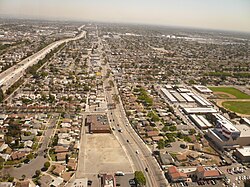
The intersection of Artesia and Pioneer Boulevards is the center of a Little India, a South Asian-American community and associated Indian food restaurants. [7] [8]

Transportation

Artesia Boulevard in Gardena Artesia Boulevard in Gardena.jpg
Artesia Boulevard in Gardena

Artesia Boulevard is serviced by Long Beach Transit line 141 between the Metro A Line station (located near its intersection with Acacia Avenue in Compton) and Los Cerritos Center, and Torrance Transit line 13 between the A Line station and Redondo Beach.[ citation needed ]

The southern end of the Metro J Line, Harbor Gateway Transit Center, was formerly named Artesia Transit Center, based on nearby Artesia Boulevard.[ citation needed ]

The intersection of Artesia Boulevard and Vermont Avenue is the southern terminus of the Dominguez Channel Bike Path. [9]

Sister city

Through the sister cities project, there is an Artesia Boulevard in Koudekerk ann den Rijn, Netherlands, as well as a Kouderkerk Street in Artesia. [10]

Related Research Articles

<span class="mw-page-title-main">California State Route 91</span> Highway in California

State Route 91 (SR 91) is a major east–west state highway in the U.S. state of California that serves several regions of the Greater Los Angeles urban area. A freeway throughout its entire length, it officially runs from Vermont Avenue in Gardena, just west of the junction with the Harbor Freeway, east to Riverside at the junction with the Pomona and Moreno Valley freeways.

<span class="mw-page-title-main">California State Route 107</span> Highway in California

State Route 107 is a state highway in the U.S. state of California that forms part of Hawthorne Boulevard in the Los Angeles Area from State Route 1 in Torrance north to Redondo Beach Boulevard at the Redondo Beach–Lawndale border.

<span class="mw-page-title-main">Sepulveda Boulevard</span> Street in Los Angeles, California

Sepulveda Boulevard is a major street and transportation corridor in the City of Los Angeles and several other cities in western Los Angeles County, California. The street parallels Interstate 405 for much of its route. Portions of Sepulveda Boulevard between Manhattan Beach and Los Angeles International Airport (LAX) are designated as part of State Route 1.

<span class="mw-page-title-main">California State Route 47</span> Highway in California

State Route 47 is a state highway in the U.S. state of California, connecting Terminal Island to the mainland in the Los Angeles area. From its south end at I-110 in San Pedro, it heads east across the Vincent Thomas Bridge to the island and the end of state maintenance. The state highway begins again at the junction with I-710 on Terminal Island, crossing the Schuyler Heim Bridge north to the mainland and the second terminus, where SR 103 begins. Signage continues along a locally maintained route, mainly Alameda Street, to the Gardena Freeway in Compton, and an unconstructed alignment follows the same corridor to the Santa Monica Freeway (I-10) near downtown Los Angeles.

<span class="mw-page-title-main">Vermont Avenue</span> Major thoroughfare in Los Angeles, CA

Vermont Avenue is one of the longest running north–south streets in City of Los Angeles and Los Angeles County, California. With a length of 23.3 miles (37.5 km), is the third longest of the north–south thoroughfares in the region. For most of its length between its southern end in San Pedro and south of Downtown Los Angeles, it runs parallel to the west of the Harbor Freeway (I-110).

<span class="mw-page-title-main">Artesia station</span> Los Angeles Metro Rail station

Artesia station is an at-grade light rail station on the A Line of the Los Angeles Metro Rail system. The station is located alongside the Union Pacific freight railroad's Wilmington Subdivision, at its intersection with Artesia Boulevard, after which the station is named, in the city of Compton, California.

<span class="mw-page-title-main">Atlantic Boulevard (Los Angeles County)</span>

Atlantic Boulevard/Atlantic Avenue/Los Robles Avenue is a major north–south thoroughfare in eastern Los Angeles County, California.

<span class="mw-page-title-main">Harbor Gateway Transit Center</span> Public transit hub in Los Angeles, California

Harbor Gateway Transit Center, formerly Artesia Transit Center, is a large bus station at the southern end of the Harbor Transitway that serves as a transport hub for the South Bay region of Los Angeles County including the Harbor Gateway neighborhood of Los Angeles and cities of Carson, Gardena, and Torrance. The station consists of one large island platform with 12 bus bays and a 980 space park and ride parking lot located in the southwest corner of Interstate 110 and California State Route 91.

<span class="mw-page-title-main">Harbor Boulevard</span> North–south road corridor in the counties of Los Angeles and Orange

Harbor Boulevard is a north–south road corridor in the counties of Los Angeles and Orange. One of the busiest routes in Orange County, the thoroughfare passes through some of the most densely populated areas in the region and carries about 8 percent of the county's bus riders. The route provides access for local residents to travel to work and for drivers travelling from Valley Boulevard in the City of Industry via Fullerton Road to Newport Beach.

<span class="mw-page-title-main">Florence Avenue</span>

Florence Avenue is a major east–west street in central Los Angeles County and South Los Angeles, in Southern California.

<span class="mw-page-title-main">Long Beach Boulevard (California)</span> Street in Los Angeles

Long Beach Boulevard is a north–south thoroughfare in Los Angeles County.

This article covers streets in Los Angeles, California between and including 41st Street and 250th Street. Major streets have their own linked articles; minor streets are discussed here.

<span class="mw-page-title-main">Rosecrans Avenue</span> Street in Los Angeles

Rosecrans Avenue is a major west-east thoroughfare in Los Angeles and Orange Counties, California, USA. It has a total length of 27.5 miles (44.3 km). The street is named after U.S. Union General William S. Rosecrans, who purchased 13,000 acres (5,300 ha) of Rancho Sausal Redondo southwest of Los Angeles in 1869. Rosecrans Avenue was originally named Drexel Avenue, and ran through the Rosecrans Rancho which is part of modern-day Gardena.

Dominguez Channel is a 15.7-mile-long (25.3 km) river in southern Los Angeles County, California, in the center of the Dominguez Watershed of 133 square miles (340 km2).

<span class="mw-page-title-main">California county routes in zone N</span>

There are 9 routes assigned to the "N" zone of the California Route Marker Program, which designates county routes in California. The "N" zone includes county highways lying in Los Angeles and Orange counties.

<span class="mw-page-title-main">San Pedro via Gardena Line</span> Pacific Electric streetcar route (1903–1940)

San Pedro via Gardena was an interurban line of the Pacific Electric Railway. This was the railway's original route to San Pedro. The line was essential in the establishment of light industry in Torrance. The route closely paralleled the present-day Harbor Transitway.

<span class="mw-page-title-main">Long Beach Line</span> Pacific Electric interurban route in California

The Long Beach Line was a major interurban railway operated by the Pacific Electric Railway between Los Angeles and Long Beach, California via Florence, Watts, and Compton. Service began in 1902 and lasted until 1961, the last line of the system to be replaced by buses.

<span class="mw-page-title-main">Zaferia, Long Beach</span> Neighborhood in Long Beach, California

Zaferia, sometimes Zafaria or Zefaria, is a neighborhood in the eastern part of Long Beach, California. It corresponds to the area around Anaheim Street and Redondo Avenue, specifically "Anaheim Street, between Temple and Loma Avenues, extending north of Pacific Coast Highway and south to 11th Street". It was founded as a small town, and shortly thereafter was served by the Pacific Electric Railway's Balboa Line, which had a station named "Zaferia" near Anaheim and Redondo at the junction with the 3rd Street/Redondo Avenue local.

<span class="mw-page-title-main">Redondo Beach via Playa del Rey Line</span> Historic streetcar line in California

The Redondo Beach via Playa del Rey was an interurban railway route of the Pacific Electric. It operated between the Hill Street Terminal and Cliffton, south of Redondo Beach, through the company's Western Division.

References

  1. "By the Wayside". The Los Angeles Times. 1882-02-03. p. 2. Retrieved 2023-09-27.
  2. "The Los Angeles Times 07 Mar 1893, page 7". Newspapers.com. Retrieved 2023-09-27.
  3. "Ancopos Park". The Long Beach Telegram and The Long Beach Daily News. 1923-11-23. p. 24. Retrieved 2023-09-27.
  4. "Home Gardens Tract". Press-Telegram. 1924-02-10. p. 33. Retrieved 2023-09-27.
  5. "Artesia Boulevard Residents to Form Improvements Body". Press-Telegram. 1924-02-07. p. 27. Retrieved 2023-09-27.
  6. "Cerritos bans trucks on Artesia Blvd". Press-Telegram. 1974-08-05. p. 14. Retrieved 2023-09-27.
  7. Virali_Dave (2023-05-05). "The Ultimate Guide to Indian Restaurants in Artesia". Eater LA. Retrieved 2023-09-27.
  8. "The Nine Best Indian Restaurants In Artesia ~ L.A. TACO". lataco.com. 2022-10-28. Retrieved 2023-09-27.
  9. "Chapter 3: Existing Conditions and Proposed Network". County of Los Angeles Bicycle Master Plan (PDF). L.A. County Department of Public Works. March 2012. p. 33. Retrieved 2023-09-27.
  10. Bloomfield, Veronica (2000). Artesia 1875-1975. Arcadia Publishing. ISBN   978-0-7385-0878-8.