North Long Beach, Long Beach, California

Last updated
North Long Beach, California
North Long Beach, California.jpg
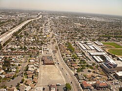
Neighborhood of North Long Beach in Long Beach, California, looking east along the south side of the 91 freeway.
Country Flag of the United States.svg United States
State Flag of California.svg  California
County Flag of Los Angeles County, California.svg Los Angeles
City Flag of Long Beach, California.png Long Beach

North Long Beach (also referred to as North Town or Northside) is a predominantly working-class area of Long Beach, California. The neighborhood is bounded to the west, north and east by the Long Beach city limits (the Rancho Dominguez unincorporated county area and the cities of Compton, Paramount, Bellflower and Lakewood), and to the south by a Union Pacific railroad track and the Bixby Knolls neighborhood. The north boundary with Paramount is only a few blocks north of the Artesia Freeway (California State Route 91).

Contents

North Long Beach is mostly residential. It is home to the Uptown Business Improvement District, which represents commercial property owners on Atlantic Avenue between Artesia Blvd and Market Street and a portion of Artesia Blvd to Orange Avenue. The organization is run by its President Pasha Darvishian. Long Beach Boulevard, and Cherry Avenue. There are some industrial businesses, mostly along the eastern edge of North Long Beach between Cherry Avenue and Paramount Boulevard, serviced by the Union Pacific Railroad.

The northern end of the district is home to Houghton Park, the Michelle Obama Neighborhood Library, Fire Station 12, and Jordan High School, while the southern end includes the Carmelitos housing project and its adjacent small shopping center. On its west side, at approximately Market Street and Long Beach Boulevard, is the site of the original Long Beach civic center dating back to the city's rancho days. The Long Beach Police Department's North Division operates a substation on the corner of Atlantic and Del Amo, at Scherer Park.

According to 2021 U.S. Census estimates, the neighborhood was home to over 93,000 people (roughly one-fifth of the total population of the city). Roughly 69% of the population was Hispanic, roughly 28% were black, roughly 0.9% were non-Hispanic whites, and roughly 1% were Asian. [1]

Demographics

The most common ancestry is Mexican. [2]

Schools

North Long Beach is in the Long Beach Unified School District.

Special events

See also

Related Research Articles

<span class="mw-page-title-main">Del Aire, California</span> Census-designated place in California, United States

Del Aire is a census-designated place (CDP) in the inland South Bay, Los Angeles County, California, United States, between El Segundo and Hawthorne. The population was 10,001 at the 2010 census, up from 9,012 at the 2000 census.

<span class="mw-page-title-main">Manhattan Beach, California</span> City in California, United States

Manhattan Beach is a city in southwestern Los Angeles County, California, United States, on the Pacific coast south of El Segundo, west of Hawthorne and Redondo Beach, and north of Hermosa Beach. As of the 2020 census, the population was 35,506.

<span class="mw-page-title-main">Norwalk, California</span> City in California, United States

Norwalk is a city in Los Angeles County, California, United States. The population was 102,773 at the 2020 census.

<span class="mw-page-title-main">Whittier, California</span> City in the United States

Whittier is a city in Southern California in Los Angeles County, part of the Gateway Cities. The 14.7-square-mile (38.0 km2) city had 87,306 residents as of the 2020 United States census, an increase of 1,975 from the 2010 census figure. Whittier was incorporated in February 1898 and became a charter city in 1955. The city is named for the Quaker poet John Greenleaf Whittier and is home to Whittier College. The city is surrounded by three unincorporated areas sharing the Whittier name, West Whittier-Los Nietos, South Whittier, and East Whittier, which combined are home to a larger population than Whittier proper.

<span class="mw-page-title-main">Buena Park, California</span> City in California, United States

Buena Park is a city in northern Orange County, California, United States. As of the 2020 census its population was 84,034. It is the location of several tourist attractions, including Knott's Berry Farm. It is about 12 miles (19 km) northwest of downtown Santa Ana, the county seat, and is within the Los Angeles metropolitan area.

<span class="mw-page-title-main">Richmond District, San Francisco</span> Neighborhood in San Francisco, California, United States

The Richmond District is a neighborhood in the northwest corner of San Francisco, California, developed initially in the late 19th century. It is sometimes confused with the city of Richmond, which is 20 miles (32 km) northeast of San Francisco.

<span class="mw-page-title-main">West Hills, Los Angeles</span> Neighborhood in Los Angeles, California, United States

West Hills is a neighborhood in the western San Fernando Valley region of the city of Los Angeles, California. It is bordered by mountain ranges to the west and the Los Angeles neighborhoods of Chatsworth to the north, Canoga Park to the east, and Woodland Hills to the south.

<span class="mw-page-title-main">Atwater Village, Los Angeles</span> Neighborhood of Los Angeles in California, United States

Atwater Village is a neighborhood in the 13th district of Los Angeles, California. Much of Atwater Village lies in the fertile Los Angeles River flood plain. Located in the northeast region of the city, Atwater borders Griffith Park and Silver Lake to the west, Glendale to the north and east and Glassell Park to the south. The eastern boundary is essentially the railroad tracks. The area has three elementary schools—two public and one private. Almost half the residents were born abroad, a high percentage for the city of Los Angeles.

West Los Angeles is an area within the city of Los Angeles, California, United States. The residential and commercial neighborhood is divided by the Interstate 405 freeway, and each side is sometimes treated as a distinct neighborhood, mapped differently by different sources. Each lies within the larger Westside region of Los Angeles County.

<span class="mw-page-title-main">Hastings Ranch, Pasadena, California</span>

Hastings Ranch is a neighborhood of Pasadena, California, which lies in northeast Pasadena. It is principally accessed by Sierra Madre Boulevard, Michillinda Avenue, Hastings Ranch Blvd., and Riviera Drive. Hastings Ranch is also identified by large shopping areas at its southernmost end and by a shopping center at the corner of Sierra Madre and Michillinda. Hastings Ranch is divided by Sierra Madre Blvd, north of the blvd is Upper Hastings Ranch and south is Lower Hastings Ranch. To the north of the Ranch are the San Gabriel Mountains and Mount Wilson.

<span class="mw-page-title-main">Harbor Gateway, Los Angeles</span> Neighborhood of Los Angeles in California, United States

The Harbor Gateway, historically and sometimes informally known as the Shoestring due to its shape, is a 5.14-square-mile residential and industrial area (13.3 km2) in the South Bay and Los Angeles Harbor Region, in the southern part of the City of Los Angeles. The neighborhood is narrow and long, running along a north-south axis.

<span class="mw-page-title-main">Mid City, Los Angeles</span> Neighborhood of Los Angeles in California, United States of America

Mid City is a neighborhood in Central Los Angeles, California.

<span class="mw-page-title-main">Belmont Heights, Long Beach, California</span> Neighborhood of Long Beach in Los Angeles, California, United States

Belmont Heights is a district in the south-east portion of the city of Long Beach, California, bordering Bluff Park, Bluff Heights, Recreation Park, Belmont Park, Belmont Shore, and the Pacific Ocean. The district commemorates the old City of Belmont Heights, which was incorporated in 1908 and annexed to Long Beach in 1909. Belmont Heights' borders are Ocean Boulevard and Livingston Drive to the south, Redondo Avenue on the west, 7th Street to the North, and Nieto Avenue to the east. The area is mostly residential, but also has an active business district, the strip of Broadway east of Redondo Avenue.

<span class="mw-page-title-main">California's 44th congressional district</span> U.S. House district for California

California's 44th congressional district is a congressional district in the U.S. state of California. The district is centered in South Los Angeles and the Los Angeles Harbor Region. It is currently represented by Democrat Nanette Barragán. The 44th district was created as a result of the redistricting cycle after the 1980 census.

The western border of Santa Monica, California, is the 3-mile (4.8 km) stretch of Santa Monica Bay. On its other sides, the city is bordered by various districts of Los Angeles: the northwestern border is Pacific Palisades, the eastern border is Brentwood north of Wilshire Boulevard and West Los Angeles south of Wilshire, the northeastern border is generally San Vicente Boulevard up to the Riviera Country Club, the southwestern border is Venice Beach and the southern border is with West Los Angeles and Mar Vista.

<span class="mw-page-title-main">West Long Beach</span> Neighborhood of Long Beach in Los Angeles, California, United States

West Long Beach is a working-class neighborhood in Long Beach, California.

Bixby Knolls is a neighborhood in Long Beach, California, named after the Bixby family.

<span class="mw-page-title-main">Alamitos Beach, Long Beach, California</span> Neighborhood in Long Beach, California, US

Alamitos Beach is a coastal neighborhood in the southern portion of the city of Long Beach, California. Although it was in unincorporated Los Angeles County when annexed by the City of Long Beach, it had been planned as its own community with a townsite.

<span class="mw-page-title-main">Rosecrans Avenue</span> Street in Los Angeles

Rosecrans Avenue is a major west-east thoroughfare in Los Angeles and Orange Counties, California, USA. It has a total length of 27.5 miles (44.3 km). The street is named after U.S. Union General William S. Rosecrans, who purchased 13,000 acres (5,300 ha) of Rancho Sausal Redondo southwest of Los Angeles in 1869. Rosecrans Avenue was originally named Drexel Avenue, and ran through the Rosecrans Rancho which is part of modern-day Gardena.

<span class="mw-page-title-main">Garfield Avenue (Los Angeles County)</span>

Garfield Avenue ' is a major north-south street in Los Angeles County, California, US.

References

  1. "U.S. Census Bureau QuickFacts: Long Beach city, California". United States Census Bureau. July 1, 2021. Retrieved November 3, 2022.
  2. Schiller, Dr. Andrew (29 March 2019). "North Long Beach Long Beach, CA 90805, Neighborhood Profile". NeighborhoodScout. Retrieved 26 February 2024.
  3. "Veterans Day Celebration". longbeach.gov. City of Long Beach.

33°51′52″N118°10′37″W / 33.864386°N 118.176896°W / 33.864386; -118.176896