Interstate 8 (I-8) is an Interstate Highway in the southwestern United States. It runs from the southern edge of Mission Bay at Sunset Cliffs Boulevard in San Diego, California, almost at the Pacific Ocean, to the junction with I-10, just southeast of Casa Grande, Arizona. In California, the freeway travels through the San Diego metropolitan area as the Ocean Beach Freeway and the Mission Valley Freeway before traversing the Cuyamaca Mountains and providing access through the Imperial Valley, including the city of El Centro. Crossing the Colorado River into Arizona, I-8 continues through the city of Yuma across the Sonoran Desert to Casa Grande, in between the cities of Phoenix and Tucson.
Interstate 70 (I-70) is a major east–west Interstate Highway in the United States that runs from I-15 near Cove Fort, Utah, to I-695 and Maryland Route 570 (MD 570) in Woodlawn, just outside Baltimore, Maryland.

U.S. Route 60 is a major east–west United States highway, traveling 2,655 miles (4,273 km) from southwestern Arizona to the Atlantic Ocean coast in Virginia. The highway's eastern terminus is in Virginia Beach, Virginia, where it is known as General Booth Boulevard, just south of the city's Oceanfront resort district at the intersection of Rudee Point Road and Harbor Point. Its original western terminus was in Springfield, Missouri; it was then extended to Los Angeles, California, but in 1964, it was truncated to end southwest of Brenda, Arizona, at an interchange with Interstate 10 (I-10) after the US 60 highway designation was removed from California. I-10 replaced US 60 from Beaumont, California, to Arizona, and California State Route 60 (SR 60) replaced US 60 from Los Angeles to Beaumont.

The Western Slope is a colloquial term generally understood to describe the part of the state of Colorado west of the Continental Divide. Bodies of water west of the Divide flow toward the Pacific Ocean; water that falls and flows east of the Divide heads east toward the Gulf of Mexico. The Western Slope encompasses about 33% of the state, but has just 10% of the state's residents. The eastern part of the state, including the San Luis Valley and the Front Range, is the more populous portion of the state.

U.S. Route 91 or U.S. Highway 91 is a 172.7-mile-long (277.9 km) north–south United States highway running from Brigham City, Utah, to Idaho Falls, Idaho, in the U.S. states of Idaho and Utah. Despite the "1" as the last digit in the number, US 91 is no longer a cross-country artery, as it has mostly been replaced by Interstate 15. The highway currently serves to connect the communities of the Cache Valley to I-15 and beyond. Prior to the mid-1970s, US 91 was an international commerce route from Long Beach, California, to the Canada–US border north of Sweetgrass, Montana. US 91 was routed on the main streets of most of the communities it served, including Las Vegas Boulevard in Las Vegas and State Street in Salt Lake City. From Los Angeles to Salt Lake, the route was built along the corridor of the Arrowhead Trail. A portion of the highway's former route in California is currently State Route 91.

U.S. Route 34 (US 34) is an east–west United States highway that runs for 1,122 miles (1,806 km) from north-central Colorado to the western suburbs of Chicago. Through Rocky Mountain National Park it is known as the Trail Ridge Road where it reaches an elevation of 12,183 feet (3,713 m), making it one of the highest paved through highways in the United States. The highway's western terminus is Granby, Colorado at US 40. Its eastern terminus is in Berwyn, Illinois at Illinois Route 43 and Historic US 66.
U.S. Route 36 (US 36) is an east–west United States Numbered Highway that travels approximately 1,414 miles (2,276 km) from Rocky Mountain National Park, Colorado to Uhrichsville, Ohio. The highway's western terminus is at Deer Ridge Junction, an intersection in Rocky Mountain National Park, Colorado, where it meets US 34. Its eastern terminus is at US 250 in Uhrichsville, Ohio.

U.S. Route 70 or U.S. Highway 70 is an east–west United States highway that runs for 2,381 miles (3,832 km) from eastern North Carolina to east-central Arizona. It is a major east–west highway of the Southeastern, Southern and Southwestern United States. Established as one of the original highways of 1926, it originally ran only to Holbrook, Arizona, then was extended in 1934 as a coast to coast route, with the current eastern terminus near the Atlantic Ocean in Atlantic, North Carolina, and the former western terminus near the Pacific Ocean in Los Angeles, California. The current western terminus was then truncated to US 60 / SR 77 in Globe, Arizona. Before the completion of the Interstate system, U.S. Highway 70 was sometimes referred to as the "Broadway of America", due to its status as one of the main east–west thoroughfares in the nation. It was also promoted as the "Treasure Trail" by the U.S. Highway 70 Association as of 1951.

A vast network of interconnected freeways in the megaregion of Southern California serves a population of over 23 million people. The Master Plan of Metropolitan Los Angeles Freeways was adopted by the Regional Planning Commission in 1947 and construction began in the early 1950s. The plan hit opposition and funding limitations in the 1970s, and by 2004, only some 61% of the original planned network had been completed.

The Midland Trail, also called the Roosevelt Midland Trail, was a national auto trail spanning the United States from Washington, D.C., west to Los Angeles, California and San Francisco, California. First road signed in 1913, it was one of the first, if not the first, marked transcontinental auto trails in America.

U.S. Route 66 is a part of a former United States Numbered Highway in the state of California that ran from the west in Santa Monica on the Pacific Ocean through Los Angeles and San Bernardino to Needles at the Arizona state line. It was truncated during the 1964 renumbering and its signage removed in 1974. The highway is now mostly replaced with several streets in Los Angeles, State Route 2 (SR 2), SR 110, SR 66, San Bernardino County Route 66 (CR 66), Interstate 15 (I-15), and I-40.
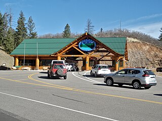
The Pikes Peak Highway is a 19-mile (31 km) toll road that runs from Cascade, Colorado to the summit of Pikes Peak in El Paso County, at an altitude of 14,115 feet (4,302 m). It is at least partially open year-round, up to the altitude where snow removal becomes excessively difficult.

Interstate 70 (I-70) is a transcontinental Interstate Highway in the United States, stretching from Cove Fort, Utah, to Baltimore, Maryland. In Colorado, the highway traverses an east–west route across the center of the state. In western Colorado, the highway connects the metropolitan areas of Grand Junction and Denver via a route through the Rocky Mountains. In eastern Colorado, the highway crosses the Great Plains, connecting Denver with metropolitan areas in Kansas and Missouri. Bicycles and other non-motorized vehicles, normally prohibited on Interstate Highways, are allowed on those stretches of I-70 in the Rockies where no other through route exists.

Interstate 40 (I-40) is an east–west Interstate Highway that has a 359.11-mile (577.93 km) section in the US state of Arizona, connecting sections in California and New Mexico. The Interstate is also referred to as the Purple Heart Trail to honor those wounded in combat who have received the Purple Heart. It enters Arizona from the west at a crossing of the Colorado River southwest of Kingman. It travels eastward across the northern portion of the state, connecting the cities of Kingman, Ash Fork, Williams, Flagstaff, Winslow, and Holbrook. I-40 continues into New Mexico, heading to Albuquerque. The highway has major junctions with U.S. Route 93 in Kingman and again approximately 22 miles (35 km) to the east and I-17 in Flagstaff.

U.S. Route 50 (US 50) is a part of the U.S. Highway System that travels from West Sacramento, California, to Ocean City, Maryland. In the U.S. state of Colorado, US 50 is a major highway crossing through the lower midsection of the state. It connects the Western Slope with the lower Front Range. The highway serves the areas of Pueblo and Grand Junction as well as many other smaller areas along its corridor. The long-term project to widen the highway from two lanes to a four lane expressway between Grand Junction and Montrose was completed in January 2005. Only about 25% of the remainder of highway 50 in Colorado is four lane highway.

K-27 is an approximately 226-mile-long (364 km) north–south state highway that parallels Kansas' western border with Colorado. It is the westernmost north–south state highway in the state. It begins at U.S. Route 56 (US-56) in Elkhart near the Oklahoma state line and travels through the seven counties that border Colorado until reaching its northern terminus north of St. Francis, where it ends at the Nebraska state line. Along the way, it intersects several major highways, including US-160 in Johnson City, US-50 and US-400 in Syracuse, US-40 in Sharon Springs, Interstate 70 (I-70) and US-24 in Goodland, and US-36 in Wheeler. The section from US-40 north to Nebraska, is designated as the Land and Sky Scenic Byway. K-27 changes time zones twice, during its trek through Kansas, the only highway in the state to do so.

U.S. Route 89 in the U.S. state of Utah is a north-south United States Highway spanning more than 502 miles (807.891 km) through the central part of the state, making it the longest road in Utah. Between Provo and Brigham City, US-89 serves as a local road, paralleling Interstate 15, but the portions from Arizona north to Provo and Brigham City northeast to Wyoming serve separate corridors. The former provides access to several national parks and Arizona, and the latter connects I-15 with Logan, the state's only Metropolitan Statistical Area not on the Interstate.
K-87 is a 8.625-mile-long (13.881 km) north–south state highway in the U.S. state of Kansas. The highway runs from the end of state maintenance, where it continues as 26th Road, in the community of Vliets north to U.S. Route 36 (US 36) west of the community of Baileyville. The highway travels through farmlamd and is a two-lane highway its entire length.
K-187 is an approximately 8-mile-long (13 km) north–south state highway in the U.S. state of Kansas. Located entirely within Nemaha County, K-187 runs from K-9 in Centralia north to U.S. Route 36 (US-36) west of Seneca. The highway passes through grasslands characteristic of the Great Plains and is a two-lane road for its entire length.

K-204 is a short 2.116-mile-long (3.405 km) east–west state highway in the north-central part of the U.S. state of Kansas. K-204's western terminus is at U.S. Route 36 (US-36) west of the city of Smith Center. The eastern terminus is at US-281 in Smith Center. K-57 is a two-lane highway its entire length.


