Hannibal is a city along the Mississippi River in Marion and Ralls counties in Missouri, United States. According to the 2020 U.S. census, the population was 17,108,[6] making it the largest city in Marion County. The bulk of the city is in Marion County, with a tiny sliver in the south extending into Ralls County.
Nestled on the Mississippi River, commerce and traffic has long been an integral part of Hannibal's development, including by river, rail and the interstate/highway system. Today the city is intersected by Interstate 72 and U.S. Routes 24, 36, and 61. Hannibal is approximately 110 miles (180km) northwest of St. Louis (also bordering the Mississippi), 195 miles (314km) east-northeast of Kansas City and 194 miles (312km) miles east of Saint Joseph (both cities on the Missouri River), and approximately 100 miles (160km) west of Springfield, Illinois.
Hannibal is not the county seat, but it has one of two county courthouses. There is also one in Palmyra, the county seat of Marion County, which is located more centrally in the county. Hannibal is the principal city of the Hannibal, Missouri micropolitan area, which consists of both Marion and Ralls counties.
History
Tom Sawyer and Huck Finn at the Foot of Cardiff Hill (1926), by Frederick Hibbard
The site of Hannibal was originally inhabited by various cultures of indigenous Native American tribes. Hannibal is home to Osterhout Mounds Park, a preservation of ancient Indian burial mounds.[7]
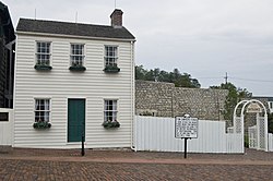
The river community was the mid-19th-century boyhood home of author Samuel Langhorne Clemens (aka Mark Twain, 1835–1910). Twain drew from his childhood settings for his novels The Adventures of Tom Sawyer (1876) and Adventures of Huckleberry Finn (1884). Numerous historical sites are associated with Mark Twain and the places depicted in his fiction.
Heritage tourism contributes to the Hannibal economy, as the city attracts both American and international tourists. The Mark Twain Boyhood Home & Museum marked its 100th anniversary in 2012; it has had visitors from all 50 states and some 60 countries.[8]
Hannibal is also the birthplace of Margaret Brown, posthumously known as the "Unsinkable Molly Brown". The cottage where Brown was born is now the Molly Brown Birthplace and Museum.[9]
Background
After the United States acquired the Louisiana Territory west of the Mississippi in 1803, European-American settlers began to enter the area. Its early European settlements were established by ethnic French colonists, some from Illinois, who largely spoke French and were Roman Catholic in religion.
Hannibal was laid out in 1819 by Moses Bates[10] and named after Hannibal Creek (later Bear Creek).[11] The name is derived from Hannibal, a hero of ancient Carthage (in modern Tunisia).[12]
The city grew slowly, with a population of 30 by 1830. But by 1846, Hannibal was Missouri's third-largest city when the Hannibal and St. Joseph Railroad was organized by John M. Clemens (Mark Twain's father) and associates.[13] This railway was built to connect to St. Joseph, Missouri, in the west, then the state's second-largest city. This railroad was the westernmost line before the Transcontinental Railroad was constructed. It transported mail for delivery to the first outpost of the Pony Express.
Construction of railroads to the area and increased steamboats on the Mississippi River had stimulated growth. In 1843 the city had also annexed the town of South Hannibal.[14] Hannibal gained "city" status by 1845.[10] By 1850 it had 2,020 residents.[14]
In the late 19th and early 20th centuries, the city served as a regional marketing center for livestock and grain, as well as other products produced locally, such as cement and shoes.[15] Cement for the Empire State Building (completed 1931) and Panama Canal was manufactured at the Atlas Portland Cement Company in the nearby unincorporated company town of Ilasco.[16]
In 2011, the Mark Twain Boyhood Home and Museum released Mark Twain: Words & Music, a CD featuring entertainers who recount Mark Twain's life in spoken word and song. Several songs were written especially for the project and refer to Hannibal, including "Huck Finn Blues" by Brad Paisley and "Run Mississippi" by Rhonda Vincent. Other artists include Jimmy Buffett as Huckleberry Finn, Clint Eastwood as Twain, and Garrison Keillor as the narrator of the project.[17][18]
Hannibal is on the west side of the Mississippi River in southeastern Marion County and is situated across the river from East Hannibal, Illinois. The next city upriver is Quincy, Illinois, 17 miles (27km) to the north, while the next city downriver is Louisiana, Missouri, 25 miles (40km) to the south.
According to the U.S. Census Bureau, Hannibal has a total area of 16.47 square miles (42.66km2), of which 16.00 square miles (41.44km2) are land and 0.47 square miles (1.22km2), or 2.84%, are water.[1]
Climate
Hannibal's climate is hot-summer humid continental (Dfa), with cold, snowy winters and hot, humid summers.[19] Three months average below freezing, seven months average above 50°F, and three months average above 22°C.
Climate data for Hannibal Water Works, Missouri (1991–2020 normals, extremes 1902–present)
The 2020 United States census[23] counted 17,108 people, 7,053 households, and 4,289 families in Hannibal. The population density was 1,069.2 per square mile (412.8/km2). There were 7,974 housing units at an average density of 498.4 per square mile (192.4/km2). The racial makeup was 84.81% (14,509) white, 7.09% (1,213) black or African-American, 0.39% (66) Native American, 0.76% (130) Asian, 0.05% (9) Pacific Islander, 0.64% (110) from other races, and 6.26% (1,071) from two or more races. Hispanic or Latino of any race was 2.4% (418) of the population.
Of the 7,053 households, 26.9% had children under the age of 18; 43.7% were married couples living together; 31.3% had a female householder with no husband present. Of all households, 31.9% consisted of individuals and 14.2% had someone living alone who was 65 years of age or older. The average household size was 2.3 and the average family size was 2.8.
23.5% of the population was under the age of 18, 10.9% from 18 to 24, 24.0% from 25 to 44, 24.3% from 45 to 64, and 18.5% who were 65 years of age or older. The median age was 37.3 years. For every 100 females, the population had 91.1 males. For every 100 females ages 18 and older, there were 89.5 males.
The 2016-2020 5-year American Community Survey[24] estimates show that the median household income was $46,504 (with a margin of error of +/- $2,507) and the median family income was $57,740 (+/- $5,451). Males had a median income of $33,537 (+/- $3,375) versus $22,147 (+/- $4,868) for females. The median income for those above 16 years old was $27,776 (+/- $1,949). Approximately, 10.6% of families and 19.1% of the population were below the poverty line, including 22.5% of those under the age of 18 and 11.7% of those ages 65 or over.
2010 census
At the 2010 census, there were 17,916 people, 7,117 households, and 4,400 families living in the city. The population density was 1,138.2 inhabitants per square mile (439.5/km2). There were 8,021 housing units at an average density of 509.6 per square mile (196.8/km2). The racial makeup of the city was 88.8% White, 7.1% African American, 0.2% Native American, 0.6% Asian, 0.1% Pacific Islander, 0.5% from other races, and 2.7% from two or more races. Hispanic or Latino of any race were 1.8%.[25]
Of the 7,117 households, 31.3% had children under the age of 18 living with them, 43.2% were married couples living together, 14.5% had a female householder with no husband present, 4.2% had a male householder with no wife present, and 38.2% were non-families. 31.6% of households were one person and 13% were one person aged 65 or older. The average household size was 2.36 and the average family size was 2.96.
The age distribution was 23.5% of residents were under the age of 18, 11.2% between the ages of 18 and 24, 24.4% from 25 to 44, 26% from 45 to 64, and 14.9% 65 or older. The median age was 37.3 years. The gender makeup of the city was 47.5% male and 52.5% female.
2000 census
As of the census[5] of 2000, there were 17,757 people, 7,017 households, and 4,554 families living in the city. The population density was 1,215.3 inhabitants per square mile (469.2/km2). There were 7,886 housing units at an average density of 539.7 per square mile (208.4/km2). The racial makeup of the city was 90.61% White, 6.57% African American, 0.35% Native American, 0.35% Asian, 0.07% Pacific Islander, 0.25% from other races, and 1.79% from two or more races. Hispanic or Latino of any race were 1.13% of the population. 25.9% were of American, 23.8% German, 10.9% Irish, and 10.0% English ancestry according to self-identification in Census 2000.
Of the 7,017 households 32.5% had children under the age of 18 living with them, 48.0% were married couples living together, 13.6% had a female householder with no husband present, and 35.1% were non-families. 30.6% of households were one person and 15.0% had someone living alone who was 65years of age or older. The average household size was 2.40 and the average family size was 2.98.
The age distribution was 25.8% under the age of 18, 10.5% from 18 to 24, 26.3% from 25 to 44, 20.6% from 45 to 64, and 16.8% who were 65years of age or older. The median age was 36years. For every 100 females, there were 86.7 males. For every 100 females age 18 and over, there were 81.8 males.
The median household income was $29,892 and the median family income was $37,264. Males had a median income of $30,677 versus $20,828 for females. The per capita income for the city was $16,902. About 11.3% of families and 14.1% of the population were below the poverty line, including 18.2% of those under age 18 and 10.8% of those age 65 or over.
Economy
A thriving artist community has developed because of its central location between the East and West coasts, and affordable and stable real estate prices.[26]
The Underwood Company built the General Mills plant here because its founder appreciated Mark Twain's writing and wanted to help his hometown.[27]
Because Hannibal is a Missouri Certified Local Government, residents, and business owners have access to federal and state tax credits, grants, and other funding sources.[29]
Lover's Leap - Cliffside overlooking the Mississippi River and downtown Hannibal. The name comes from the local legend of two Native American lovers who were forbidden by their respective tribes to marry each other. Warriors were sent to kill the lovers, but the lovers, finding themselves cornered at the top of the cliff, embraced each other and threw themselves off the cliff to their deaths.
Mark Twain Cave - The cave that inspired Twain's tale of a lost Tom & Becky.
Mark Twain Memorial Lighthouse - The only lighthouse built inland features a panoramic view of Hannibal and the Mississippi River. 244 steps to the top.
Sawyer's Creek Fun Park - Amusement complex on the riverfront.
Tom & Becky Appearances - Local 7th grade children are chosen to portray the famous literary couple in local appearances and in downtown Hannibal every Saturday and Sunday from March to October.
National Tom Sawyer Days - Fence painting contest, frog jumping contest, mud volleyball, local arts and crafts and Fourth of July fireworks display from Lover's Leap.
Government
Hannibal has a Municipal Home Rule form of government. Public services include police, fire, parks and recreation, public works, streets, inspections, tourism, library, and airport. There is a municipal court, and the Marion County Courthouse is located in Hannibal. A second county courthouse is located in the county seat in Palmyra.
Hannibal High School was founded in 1896. This public high school is part of the Hannibal School District #60, with K-12 grades serving Hannibal and surrounding areas. It is located at 4500 McMasters Ave. 63401.[36]
Hannibal-LaGrange University is a four-year, Christian liberal arts university accredited by the Higher Learning Commission. Founded in 1858 in LaGrange, Missouri, the campus moved downriver to Hannibal in 1928, merging with then Hannibal College to form Hannibal-LaGrange College. Dr. Robert Matz was elected the 18th president of Hannibal-LaGrange University in 2022.
Moberly Area Community College (MACC-Hannibal Area Higher Education Center) is a two-year community college established in 1999. The MACC-Hannibal Campus is located on Shinn Lane near the hospital.
Hannibal's lending library, the Hannibal Free Public Library, was the first free public library in the state of Missouri.[37][38]
Hannibal Regional Airport (formerly Hannibal Municipal Airport) was renamed in 2003 as William P. Lear Field, in honor of Lear. He grew up in Hannibal and invented the Lear Jet. The airport is located 4 miles (6.4km) west of the southern area and has one runway 4,400 feet (1,300m) x 100 feet (30m).
↑"Station: Hannibal WTR WKS, MO". U.S. Climate Normals 2020: U.S. Monthly Climate Normals (1991-2020). National Oceanic and Atmospheric Administration. Retrieved July 22, 2021.
Paul A. Shackel, "America's home town: fiction, Mark Twain, and the re‐creation of Hannibal, Missouri." International Journal of Heritage Studies 17.3 (2011): 197-213. online
This page is based on this Wikipedia article Text is available under the CC BY-SA 4.0 license; additional terms may apply. Images, videos and audio are available under their respective licenses.