Rensselaer, Missouri

Last updated

Rensselaer, Missouri
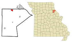
Ralls County Missouri Incorporated and Unincorporated areas Rensselaer Highlighted.svg
Location of Rensselaer, Missouri
Coordinates: 39°40′09″N91°32′19″W / 39.66917°N 91.53861°W / 39.66917; -91.53861 [1]
Country United States
State Missouri
County Ralls
Area
[2]
  Total2.01 sq mi (5.20 km2)
  Land1.96 sq mi (5.06 km2)
  Water0.05 sq mi (0.14 km2)
Elevation
[1]
692 ft (211 m)
Population
 (2020)
  Total253
  Density129.41/sq mi (49.96/km2)
Time zone UTC-6 (Central (CST))
  Summer (DST) UTC-5 (CDT)
FIPS code 29-61184 [3]
GNIS feature ID2399058 [1]

Rensselaer is a village in Ralls County, Missouri, United States. The population was 253 at the 2020 census. [4] It is part of the Hannibal Micropolitan Statistical Area.

Contents

History

Rensselaer was laid out in 1876. [5] The community took its name from nearby Rensselaer Academy. [6] A post office called Rensselaer was established in 1871, and remained in operation until 1953. [7]

St. Peter's Catholic Church was listed on the National Register of Historic Places in 1980. [8]

Geography

According to the United States Census Bureau, the village has a total area of 2.01 square miles (5.21 km2), of which 1.96 square miles (5.08 km2) is land and 0.05 square miles (0.13 km2) is water. [9]

Demographics

Historical population
CensusPop.Note
2000 145
2010 22857.2%
2020 25311.0%
U.S. Decennial Census [10]

2010 census

As of the census [11] of 2010, there were 228 people, 78 households, and 61 families living in the village. The population density was 116.3 inhabitants per square mile (44.9/km2). There were 87 housing units at an average density of 44.4 per square mile (17.1/km2). The racial makeup of the village was 100.0% White. Hispanic or Latino of any race were 0.4% of the population.

There were 78 households, of which 42.3% had children under the age of 18 living with them, 69.2% were married couples living together, 2.6% had a female householder with no husband present, 6.4% had a male householder with no wife present, and 21.8% were non-families. 17.9% of all households were made up of individuals, and 3.8% had someone living alone who was 65 years of age or older. The average household size was 2.73 and the average family size was 3.15.

The median age in the village was 34.5 years. 28.9% of residents were under the age of 18; 5.4% were between the ages of 18 and 24; 30.3% were from 25 to 44; 26.3% were from 45 to 64; and 9.2% were 65 years of age or older. The gender makeup of the village was 49.6% male and 50.4% female.

2000 census

As of the census [3] of 2000, there were 145 people, 48 households, and 40 families living in the village. The population density was 73.8 inhabitants per square mile (28.5/km2). There were 53 housing units at an average density of 27.0 per square mile (10.4/km2). The racial makeup of the village was 100.00% White. Hispanic or Latino of any race were 3.45% of the population.

There were 48 households, out of which 43.8% had children under the age of 18 living with them, 72.9% were married couples living together, 6.3% had a female householder with no husband present, and 14.6% were non-families. 12.5% of all households were made up of individuals, and 4.2% had someone living alone who was 65 years of age or older. The average household size was 2.79 and the average family size was 3.00.

In the village, the population was spread out, with 26.2% under the age of 18, 6.9% from 18 to 24, 31.7% from 25 to 44, 26.9% from 45 to 64, and 8.3% who were 65 years of age or older. The median age was 35 years. For every 100 females, there were 107.1 males. For every 100 females age 18 and over, there were 105.8 males.

The median income for a household in the village was $55,179, and the median income for a family was $56,806. Males had a median income of $30,938 versus $19,375 for females. The per capita income for the village was $18,103. None of the families and 4.4% of the population lived below the poverty line, including those under eighteen and those over 64.
Related Research Articles

<span class="mw-page-title-main">Rocheport, Missouri</span> City in Missouri, United States

Rocheport is a city in Boone County, Missouri, United States. It is part of the Columbia, Missouri Metropolitan Statistical Area. The population was 239 at the 2010 census. Rocheport includes the Rocheport Historic District, an area with buildings dating from 1830 and which is listed on the National Register of Historic Places.

<span class="mw-page-title-main">Gentry, Missouri</span> Village in Missouri, United States

Gentry is a village in Gentry County, Missouri, United States. The population was 56 at the 2020 census.

<span class="mw-page-title-main">Eagleville, Missouri</span> Village in Missouri, United States

Eagleville is a village in northern Harrison County, Missouri, United States. The population was 275 at the 2020 census.

<span class="mw-page-title-main">Mooresville, Missouri</span> Village in Missouri, United States

Mooresville is a village in western Livingston County, Missouri, United States. The population was 98 at the 2020 census.

<span class="mw-page-title-main">Junction City, Missouri</span> Village in Missouri, United States

Junction City is a village in Madison County, Missouri, United States. The population was 283 at the 2020 census, down from 327 in 2010.

<span class="mw-page-title-main">Laurie, Missouri</span> City in Missouri, US

Laurie is a city in southern Morgan and northern Camden counties, Missouri, United States. The population was 939 at the 2020 census.

<span class="mw-page-title-main">Bakersfield, Missouri</span> Village in Missouri, United States

Bakersfield is a village in southeastern Ozark County in the Ozarks of southern Missouri, United States. The population was 186 at the 2020 census.

<span class="mw-page-title-main">Ferrelview, Missouri</span> Village in Missouri, United States

Ferrelview is a village in Platte County, Missouri in the United States. It is within the Kansas City metropolitan area. The population was 451 at the 2010 census.

<span class="mw-page-title-main">Flemington, Missouri</span> Village in Missouri, United States

Flemington is a village in Polk County, Missouri, United States. The population was 148 at the 2010 census. It is part of the Springfield, Missouri Metropolitan Statistical Area.

<span class="mw-page-title-main">Halfway, Missouri</span> Village in Missouri, United States

Halfway is a village in Polk County, Missouri, United States. According to the 2010 census, the population of Halfway is 173. It is part of the Springfield, Missouri Metropolitan Statistical Area.

<span class="mw-page-title-main">Leonard, Missouri</span> Village in Missouri, United States

Leonard is a village in northwestern Shelby County, Missouri, United States. The population was 57 at the 2020 census.

<span class="mw-page-title-main">Greendale, Missouri</span> City in Missouri, United States

Greendale is a city in St. Louis County, Missouri, United States. The population was 651 at the 2010 census.

<span class="mw-page-title-main">Mackenzie, Missouri</span> Village in Missouri, United States

Mackenzie is an unincorporated community in St. Louis County, Missouri, United States. The population was 134 at the 2010 census.

<span class="mw-page-title-main">Norwood Court, Missouri</span> Village in Missouri, United States

Norwood Court is a village in St. Louis County, Missouri, United States. The population was 959 at the 2010 census.

<span class="mw-page-title-main">Westwood, Missouri</span> Village in Missouri, United States

Westwood is a village in west St. Louis County, Missouri, United States. The population was 316 at the 2020 census.

<span class="mw-page-title-main">Taneyville, Missouri</span> Village in Missouri, United States

Taneyville is a village in Taney County, Missouri, United States. The population was 274 at the 2020 census. It is part of the Branson, Missouri Micropolitan Statistical Area.

<span class="mw-page-title-main">Manley, Nebraska</span> Village in Nebraska, United States

Manley is a village in Cass County, Nebraska, United States. The population was 167 at the 2020 census.

<span class="mw-page-title-main">Oakwood Park, Missouri</span> Village in Missouri, United States

Oakwood Park is a village in Clay County, Missouri, United States. The population was 189 at the 2020 census. It is part of the Kansas City metropolitan area.

<span class="mw-page-title-main">Jacksonville, Missouri</span> Village in Missouri, United States

Jacksonville is a village in Randolph County, Missouri, United States. The population was 151 at the 2010 census.

<span class="mw-page-title-main">Argyle, Missouri</span> Town in Missouri, United States

Argyle is a town in Osage and Maries counties in the U.S. state of Missouri. The population was 144 at the 2020 census.

References

  1. 1 2 3 U.S. Geological Survey Geographic Names Information System: Rensselaer, Missouri
  2. "ArcGIS REST Services Directory". United States Census Bureau. Retrieved August 28, 2022.
  3. 1 2 "U.S. Census website". United States Census Bureau . Retrieved January 31, 2008.
  4. "Explore Census Data". data.census.gov. Retrieved January 5, 2022.
  5. Ramsay, Robert L. (1952). Our Storehouse of Missouri Place Names. University of Missouri Press. p. 25. ISBN   9780826205865.
  6. "Ralls County Place Names, 1928–1945". The State Historical Society of Missouri. Archived from the original on June 24, 2016. Retrieved December 11, 2016.
  7. "Post Offices". Jim Forte Postal History. Retrieved November 27, 2016.
  8. "National Register Information System". National Register of Historic Places . National Park Service. July 9, 2010.
  9. "US Gazetteer files 2010". United States Census Bureau. Archived from the original on January 25, 2012. Retrieved July 8, 2012.
  10. "Census of Population and Housing". Census.gov. Retrieved June 4, 2015.
  11. "U.S. Census website". United States Census Bureau . Retrieved July 8, 2012.