
The Mississippi River is the primary river, and second-longest river, of the largest drainage basin in the United States. From its traditional source of Lake Itasca in northern Minnesota, it flows generally south for 2,340 miles (3,766 km) to the Mississippi River Delta in the Gulf of Mexico. With its many tributaries, the Mississippi's watershed drains all or parts of 32 U.S. states and two Canadian provinces between the Rocky and Appalachian mountains. The main stem is entirely within the United States; the total drainage basin is 1,151,000 sq mi (2,980,000 km2), of which only about one percent is in Canada. The Mississippi ranks as the thirteenth-largest river by discharge in the world. The river either borders or passes through the states of Minnesota, Wisconsin, Iowa, Illinois, Missouri, Kentucky, Tennessee, Arkansas, Mississippi, and Louisiana.

The Great River Road is a collection of state and local roads that follow the course of the Mississippi River through ten states of the United States. They are Minnesota, Wisconsin, Iowa, Illinois, Missouri, Kentucky, Tennessee, Arkansas, Mississippi and Louisiana. It formerly extended north into Canada, serving the provinces of Ontario and Manitoba. The road is designated as both a National Scenic Byway and an All-American Road in several states along the route.
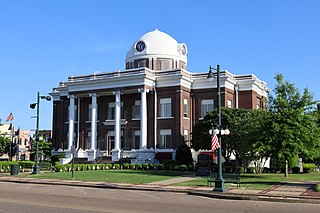
Dyer County is a county located in the westernmost part of the U.S. state of Tennessee. As of the 2020 census, the population was 36,801. The county seat is Dyersburg. Dyer County comprises the Dyersburg, TN Micropolitan Statistical Area.
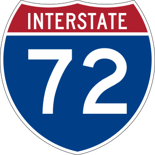
Interstate 72 (I-72) is an Interstate Highway in the midwestern United States. Its western terminus is in Hannibal, Missouri, at an intersection with U.S. Route 61 (US 61); its eastern terminus is at Country Fair Drive in Champaign, Illinois. The route runs through the major cities of Decatur, Illinois, and Springfield, Illinois. In 2006, the Illinois General Assembly dedicated all of I-72 as Purple Heart Memorial Highway. The stretch between Springfield and Decatur is also called Penny Severns Memorial Expressway, and the section between mile 35 and the Mississippi River is known as the Free Frank McWorter Historic Highway.

Hannibal is a city along the Mississippi River in Marion and Ralls counties in the U.S. state of Missouri. According to the 2020 U.S. Census, the population was 17,312, making it the largest city in Marion County. The bulk of the city is in Marion County, with a tiny sliver in the south extending into Ralls County.

Samuel Langhorne Clemens, known by the pen name Mark Twain, was an American writer, humorist, essayist, entrepreneur, publisher, and lecturer. He was praised as the "greatest humorist the United States has produced", and William Faulkner called him "the father of American literature". His novels include The Adventures of Tom Sawyer (1876) and its sequel, Adventures of Huckleberry Finn (1884), with the latter often called the "Great American Novel". Twain also wrote A Connecticut Yankee in King Arthur's Court (1889) and Pudd'nhead Wilson (1894), and co-wrote The Gilded Age: A Tale of Today (1873) with Charles Dudley Warner.

Life on the Mississippi is a memoir by Mark Twain of his days as a steamboat pilot on the Mississippi River before the American Civil War published in 1883. It is also a travel book, recounting his trips on the Mississippi River from St. Louis to New Orleans, and then from New Orleans to Saint Paul many years after the war.

U.S. Route 65 is a north–south United States highway in the southern and midwestern United States. The southern terminus of the route is at U.S. Route 425 in Clayton, Louisiana. The northern terminus is at Interstate 35 just south of Interstate 90 in Albert Lea, Minnesota. Parts of its modern route in Iowa and historic route in Minnesota follow the old Jefferson Highway.
The Avenue of the Saints is a 563-mile-long (906 km) highway in the Midwestern United States that connects St. Louis, Missouri and St. Paul, Minnesota.

U.S. Route 36 (US 36) is an east–west United States highway that travels approximately 1,414 miles (2,276 km) from Rocky Mountain National Park, Colorado to Uhrichsville, Ohio. The highway's western terminus is at Deer Ridge Junction, an intersection in Rocky Mountain National Park, Colorado, where it meets US 34. Its eastern terminus is at US 250 in Uhrichsville, Ohio.

The McKinley Bridge is a steel truss bridge across the Mississippi River. It connects northern portions of the city of St. Louis, Missouri with Venice, Illinois. It opened in 1910 and was taken out of service on October 30, 2001. The bridge was reopened for pedestrian and bicyclists on November 17, 2007 with a grand re-opening celebration. Since December 2007, McKinley has been open to vehicular traffic as well. It is accessible from Illinois Route 3 in Illinois and from the intersection of Salisbury and North 9th Street in the city of St. Louis. The bridge carried both railroad and vehicular traffic across the Mississippi River for decades. By 1978, the railroad line over the span was closed, and an additional set of lanes was opened for vehicles in the inner roadway.
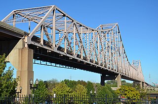
The Martin Luther King Bridge in St. Louis, Missouri, is a cantilever truss bridge of about 4,000 feet (1,200 m) in total length across the Mississippi River, connecting St. Louis with East St. Louis, Illinois. Opened in 1951, the bridge serves as traffic relief connecting the concurrent freeways of Interstate 55, Interstate 64, and U.S. Route 40 with the downtown streets of St. Louis. It was renamed for King in 1968 after the national civil rights leader was assassinated that year.

Forgottonia, also spelled Forgotonia, is the name given to a 16-county region in Western Illinois in the late 1960s and early 1970s. This geographic region forms the distinctive western bulge of Illinois that is roughly equivalent to "The Tract", the Illinois portion of the Military Tract of 1812, along and west of the Fourth Principal Meridian. Since this wedge-shaped region lies between the Illinois and Mississippi rivers, it has historically been isolated from the eastern portion of Central Illinois.

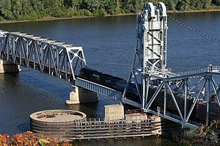
The Cairo Mississippi River Bridge is a type of cantilever bridge known as a Steel Truss Through Deck carrying U.S. Route 60 and U.S. Route 62 across the Mississippi River. Located in the tri-state area of Illinois, Kentucky, and Missouri, it connects Cairo, Illinois at its northern terminus to Bird's Point, Missouri at its southern terminus. The bridge is currently closed for renovation until October 1, 2024.
The Wabash Bridge carries one railroad track across the Mississippi River between Hannibal, Missouri, and Pike County, Illinois. Built by the Wabash Railroad, the bridge is today owned by the Norfolk Southern Railway.
In the U.S. state of Illinois, U.S. Route 36 (US 36) is an east–west highway that runs across the central portion of the state. It runs east from Missouri over the Mark Twain Memorial Bridge over the Mississippi River with Interstate 72. The eastern terminus of U.S. 36 in Illinois is located near the unincorporated area of Raven near the Illinois-Indiana state line. This is a distance of 216.47 miles (348.37 km).

Interstate 44 (I-44) in the US state of Missouri runs northeast from the Oklahoma state line near Joplin to I-70 in Downtown St. Louis. It runs for about 293 miles (472 km) in the state, and is the longest Interstate Highway in the state.
U.S. Route 36 in the state of Missouri is an expressway with many freeway sections, connecting Kansas to Illinois. From Cameron to the Illinois state line, it forms part of the principal route between Kansas City and Chicago, known as the Chicago–Kansas City Expressway.

The Salt River is a tributary of the Mississippi River in eastern Missouri in the United States. The river is approximately 55 miles (89 km) long and drains an area of 2,518 sq mi (6,520 km2) in parts of twelve Missouri counties.

The Mark Twain Memorial Bridge was a cantilevered through truss bridge carrying US 36 over the Mississippi River. It was replaced in 2000 with the extension of I-72 and subsequently demolished.

