The Mississippi River is the primary river of the largest drainage basin in the United States. From its traditional source of Lake Itasca in northern Minnesota, it flows generally south for 2,340 miles (3,766 km) to the Mississippi River Delta in the Gulf of Mexico. With its many tributaries, the Mississippi's watershed drains all or parts of 32 U.S. states and two Canadian provinces between the Rocky and Appalachian mountains. The river either borders or passes through the states of Minnesota, Wisconsin, Iowa, Illinois, Missouri, Kentucky, Tennessee, Arkansas, Mississippi, and Louisiana. The main stem is entirely within the United States; the total drainage basin is 1,151,000 sq mi (2,980,000 km2), of which only about one percent is in Canada. The Mississippi ranks as the world's tenth-largest river by discharge flow, and the largest in North America.
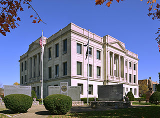
Pike County is a county on the eastern border of the U.S. state of Missouri, bounded by the Mississippi River. As of the 2020 census, the population was 17,587. Its county seat is Bowling Green. Its namesake was a city in middle Kentucky, a region from where many early migrants came. The county was organized December 14, 1818, and named for explorer Zebulon Pike. The folksong "Sweet Betsy from Pike" is generally thought to be associated with Pike County, Missouri.

Louisiana is a city in Pike County, Missouri, United States. The population was 3,364 at the 2010 census. Louisiana is located in northeast Missouri, on the Mississippi River, south of Hannibal.

James Beauchamp Clark was an American politician and attorney who served as the 36th speaker of the United States House of Representatives from 1911 to 1919. He was the only Democrat to serve as speaker during the Progressive Era when Republicans dominated the House, Senate, and presidency. Clark represented Missouri's 9th district between 1893 and 1921.

The Eads Bridge is a combined road and railway bridge over the Mississippi River connecting the cities of St. Louis, Missouri, and East St. Louis, Illinois. It is located on the St. Louis riverfront between Laclede's Landing to the north, and the grounds of the Gateway Arch to the south. The bridge is named for its designer and builder, James Buchanan Eads. Work on the bridge began in 1867, and it was completed in 1874. The Eads Bridge was the first bridge across the Mississippi south of the Missouri River. Earlier bridges were located north of the Missouri, where the Mississippi is narrower. None of the earlier bridges survived, which means that the Eads Bridge is also the oldest bridge on the river.

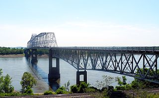
The Stan Musial Veterans Memorial Bridge is a bridge across the Mississippi River in the United States between St. Clair County, Illinois, and the city of St. Louis, Missouri. Built between April 19, 2010, and July 2013, the bridge opened on February 9, 2014. The cable-stayed bridge has a main span of 1,500 feet (460 m).

Forgottonia, also spelled Forgotonia, is the name given to a 16-county region in Western Illinois in the late 1960s and early 1970s. This geographic region forms the distinctive western bulge of Illinois that is roughly equivalent to "The Tract", the Illinois portion of the Military Tract of 1812, along and west of the Fourth Principal Meridian. Since this wedge-shaped region lies between the Illinois and Mississippi rivers, it has historically been isolated from the eastern portion of Central Illinois.
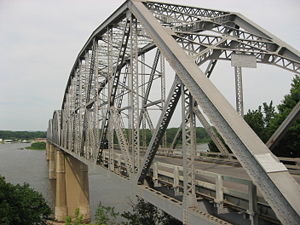
The Champ Clark Bridge is a steel girder bridge over the Mississippi River connecting Louisiana, Missouri with Pike County, Illinois.

The Clark Bridge is a cable-stayed bridge across the Mississippi River between West Alton, Missouri and Alton, Illinois. Named after explorer William Clark like the bridge it replaced, the cable-stayed bridge opened in 1994. It carries U.S. Route 67 across the river. It is the northernmost river crossing in the St. Louis metropolitan area.

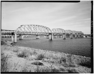
The Cairo Mississippi River Bridge is a steel truss through deck bridge carrying U.S. Route 60 and U.S. Route 62 across the Mississippi River. Located in the tri-state area of Illinois, Kentucky, and Missouri, it connects Cairo, Illinois at its northern terminus to Bird's Point, Missouri at its southern terminus. The bridge is currently closed for renovation until October 1, 2024. The bridge measures 5,175.5 feet in length with a main span of 700.9 feet and a width of 20 feet. At its apex, the bridge stands 114 feet above the river with a 675-foot (206-meter) navigation channel. In the years since the construction of the bridge, the town of Cairo has experienced an 81% population decline, the most dramatic decrease of any principal city in the United States. The bridges initially played a part in the town's demise as the ferry and railroad industries were severely impacted.
The Chester Bridge is a continuous truss bridge connecting Missouri's Route 51 with Illinois Route 150 across the Mississippi River between Perryville, Missouri and Chester, Illinois. It is the only motor-traffic bridge spanning the Mississippi River between St. Louis and Cape Girardeau, Missouri.

The New Chain of Rocks Bridge is a pair of bridges across the Mississippi River on the north edge of St. Louis, Missouri. It was constructed in 1966 to bypass the Chain of Rocks Bridge immediately to the south. It originally carried traffic for Bypass US 66 and currently carries traffic for Interstate 270. The bridge opened to traffic on September 2, 1966.

The Louisiana Railroad Bridge carries a single track rail line across the Mississippi River between Louisiana, Missouri and Pike County, Illinois, United States. Built by the Chicago and Alton Railroad, the structure is currently owned by the Canadian Pacific Kansas City following a series of sales and consolidation in the railroad industry.

The Cape Girardeau Bridge was a continuous through truss bridge connecting Missouri's Route 34 with Illinois Route 146 across the Mississippi River between Cape Girardeau, Missouri, and East Cape Girardeau, Illinois. It was replaced in 2003 with the Bill Emerson Memorial Bridge.
The Old Clark Bridge was a bridge that carried U.S. Route 67 across the Mississippi River between West Alton, Missouri and Alton, Illinois. It was constructed beginning in 1927, was replaced by the Clark Bridge and was demolished in 1994. The bridge was initially a toll bridge.
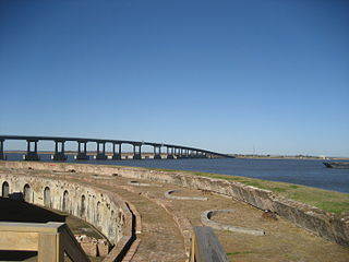
The Fort Pike Bridge, named after nearby Fort Pike, carries U.S. Route 90 across the Rigolets on the eastern side of Lake Pontchartrain between New Orleans and Slidell in Louisiana. It is owned and operated by Louisiana Department of Transportation and Development The bridge opened on June 9, 1930, and along with the Chef Menteur Bridge provided a free route between New Orleans and the Mississippi Gulf Coast. This was the site of Jayne Mansfield's death in June 1967. A new span was constructed just to the north of the old span.
The Washington Bridge is a concrete girder bridge that carries Route 47 over the Missouri River in Washington, Missouri. It replaces a cantilever truss bridge of the same name that passed between Franklin County, Missouri and Warren County, Missouri. It has also been known as the Route 47 Missouri River Bridge.
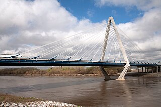
The Christopher S. Bond Bridge in Kansas City, Missouri is a cable-stayed bridge across the Missouri River. It carries I-29/I-35/US 71. The bridge opened to limited traffic on September 27, 2010, and all lanes opened on December 18, 2010. The Bond bridge is a replacement for the Paseo Bridge.

Several special routes of U.S. Route 61 exist in the states of Louisiana, Mississippi, Missouri, and Iowa.

U.S. Route 54 in Missouri is a west-east highway that runs between the Kansas state line in Nevada, Missouri and the Illinois state line in Louisiana, Missouri.