
The Mississippi River is the primary river of the largest drainage basin in the United States. From its traditional source of Lake Itasca in northern Minnesota, it flows generally south for 2,340 miles (3,766 km) to the Mississippi River Delta in the Gulf of Mexico. With its many tributaries, the Mississippi's watershed drains all or parts of 32 U.S. states and two Canadian provinces between the Rocky and Appalachian mountains. The river either borders or passes through the states of Minnesota, Wisconsin, Iowa, Illinois, Missouri, Kentucky, Tennessee, Arkansas, Mississippi, and Louisiana. The main stem is entirely within the United States; the total drainage basin is 1,151,000 sq mi (2,980,000 km2), of which only about one percent is in Canada. The Mississippi ranks as the world's tenth-largest river by discharge flow, and the largest in North America.

Gateway Arch National Park is a national park of the United States located in St. Louis, Missouri, near the starting point of the Lewis and Clark Expedition.

The Eads Bridge is a combined road and railway bridge over the Mississippi River connecting the cities of St. Louis, Missouri, and East St. Louis, Illinois. It is located on the St. Louis riverfront between Laclede's Landing to the north, and the grounds of the Gateway Arch to the south. The bridge is named for its designer and builder, James Buchanan Eads. Work on the bridge began in 1867, and it was completed in 1874. The Eads Bridge was the first bridge across the Mississippi south of the Missouri River. Earlier bridges were located north of the Missouri, where the Mississippi is narrower. None of the earlier bridges survived, which means that the Eads Bridge is also the oldest bridge on the river.

The Stan Musial Veterans Memorial Bridge is a bridge across the Mississippi River in the United States between St. Clair County, Illinois, and the city of St. Louis, Missouri. Built between April 19, 2010, and July 2013, the bridge opened on February 9, 2014. The cable-stayed bridge has a main span of 1,500 feet (460 m).
The Avenue of the Saints is a 563-mile-long (906 km) highway in the Midwestern United States that connects St. Louis, Missouri, and St. Paul, Minnesota.

The Huey P. Long Bridge, located in Jefferson Parish, Louisiana, is a cantilevered steel through-truss bridge that carries a two-track railroad line over the Mississippi River at mile 106.1, with three lanes of US 90 on each side of the central tracks. It is several kilometers upriver from the city of New Orleans. The East Bank entrance is at Elmwood, Louisiana, and the West Bank at Bridge City.
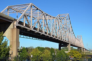
The Martin Luther King Bridge in St. Louis, Missouri, is a cantilever truss bridge of about 4,000 feet (1,200 m) in total length across the Mississippi River, connecting St. Louis with East St. Louis, Illinois. Opened in 1951, the bridge serves as traffic relief connecting the concurrent freeways of Interstate 55, Interstate 64, and U.S. Route 40 with the downtown streets of St. Louis. It was renamed for King in 1968 after the national civil rights leader was assassinated that year.

Forgottonia, also spelled Forgotonia, is the name given to a 16-county region in Western Illinois in the late 1960s and early 1970s. This geographic region forms the distinctive western bulge of Illinois that is roughly equivalent to "The Tract", the Illinois portion of the Military Tract of 1812, along and west of the Fourth Principal Meridian. Since this wedge-shaped region lies between the Illinois and Mississippi rivers, it has historically been isolated from the eastern portion of Central Illinois.

The Quincy Memorial Bridge is a truss bridge over the Mississippi River in Quincy, Illinois. It brings eastbound U.S. Highway 24 into the city of Quincy from Missouri. It was built in 1930, initially as a toll bridge, and remains structurally sound.

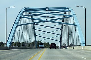
The Clark Bridge is a cable-stayed bridge across the Mississippi River between West Alton, Missouri and Alton, Illinois. Named after explorer William Clark like the bridge it replaced, the cable-stayed bridge opened in 1994. It carries U.S. Route 67 across the river. It is the northernmost river crossing in the St. Louis metropolitan area.

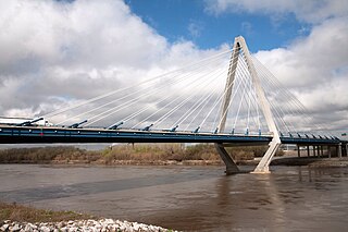
The Greenville Bridge, or the Jesse Brent Memorial Bridge, is a cable-stayed bridge over the Mississippi River, in the United States, carrying US 82 and US 278 between Refuge, Mississippi, and Shives, Arkansas. When it opened in 2010, it was the fourth-longest cable-stayed bridge in North America.
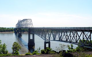
The Chester Bridge is a continuous truss bridge connecting Missouri's Route 51 with Illinois Route 150 across the Mississippi River between Perryville, Missouri and Chester, Illinois. It is the only motor-traffic bridge spanning the Mississippi River between St. Louis and Cape Girardeau, Missouri.

The New Chain of Rocks Bridge is a pair of bridges across the Mississippi River on the north edge of St. Louis, Missouri. It was constructed in 1966 to bypass the Chain of Rocks Bridge immediately to the south. It originally carried traffic for Bypass US 66 and currently carries traffic for Interstate 270. The bridge opened to traffic on September 2, 1966.

Transportation in Greater St. Louis, Missouri includes road, rail, ship, and air transportation modes connecting the bi-state St. Louis metropolitan area with surrounding communities throughout the Midwest, national transportation networks, and international locations. The Greater St. Louis region also supports a multi-modal transportation network that includes bus, paratransit, and light rail service in addition to shared-use paths, bike lanes and greenways.

HNTB Corporation is an American infrastructure design firm. Founded in 1914 in Kansas City, Missouri, HNTB began with the partnership made by Ernest Emmanuel Howard with the firm Waddell & Harrington, founded in 1907.
The Amelia Earhart Memorial Bridge is a network tied arch bridge over the Missouri River on U.S. Route 59 between Atchison, Kansas and Buchanan County, Missouri. It opened in December 2012, replacing a previous truss bridge with the same name.
The Christopher S. Bond Bridge in Kansas City, Missouri is a cable-stayed bridge across the Missouri River. It carries I-29/I-35/US 71. The bridge opened to limited traffic on September 27, 2010, and all lanes opened on December 18, 2010. The Bond bridge is a replacement for the Paseo Bridge.

U.S. Route 67 is the portion of a north-south highway in Missouri that starts at the Arkansas state line south of Neelyville and ends at the Illinois state line northeast of West Alton.

U.S. Route 54 in Missouri is a west-east highway that runs between the Kansas state line in Nevada, Missouri and the Illinois state line in Louisiana, Missouri.

The Champ Clark Bridge was a five-span truss bridge over the Mississippi River connecting Louisiana, Missouri with the state of Illinois via US 54. It opened in 1928. In 2019, the bridge was replaced by a new bridge of the same name.
