Bowling Green, Missouri

Last updated

Bowling Green, Missouri
City of Bowling Green
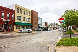
Bowling Green, MO.jpg
Bowling Green, Missouri in 2015
Pike County Missouri Incorporated and Unincorporated areas Bowling Green Highlighted.svg
Location of Bowling Green, Missouri
Coordinates: 39°20′41″N92°12′11″W / 39.34472°N 92.20306°W / 39.34472; -92.20306
Country United States
State Missouri
County Pike
Area
[1]
  Total2.70 sq mi (7.00 km2)
  Land2.69 sq mi (6.97 km2)
  Water0.01 sq mi (0.04 km2)
Elevation
[2]
892 ft (272 m)
Population
 (2020)
  Total4,195
  Density1,560.06/sq mi (602.28/km2)
Time zone UTC-6 (Central (CST))
  Summer (DST) UTC-5 (CDT)
ZIP code
63334
Area code 573
FIPS code 29-07660 [3]
GNIS feature ID2394228 [2]
U.S. Routes US 54.svg US 61.svg
Website http://www.bowlinggreen-mo.gov/

Bowling Green is a city and the county seat of in Pike County, Missouri, United States. The population was 5,334 at the 2010 census. [4]

Contents

History

Bowling Green was settled in 1819, and designated county seat in 1824. [5] Settled chiefly by migrants from Kentucky and Virginia, it was named after Bowling Green, Kentucky. [6] [7]

The James Beauchamp Clark House was listed on the National Register of Historic Places in 1976. [8]

Geography

Bowling Green lies at the junction of US highways 54 and 61. US 54 links Bowling Green with Illinois to the east and Jefferson City and the Lake of the Ozarks to the south and west, while US 61 connects the city with Hannibal to the north and the St. Louis area to the south.

According to the United States Census Bureau, the city has a total area of 2.70 square miles (6.99 km2), of which, 2.69 square miles (6.97 km2) is land and 0.01 square miles (0.03 km2) is water. [9]

Climate

Climate data for Bowling Green 1 E, Missouri (1991–2020 normals, extremes 1963–present)
MonthJanFebMarAprMayJunJulAugSepOctNovDecYear
Record high °F (°C)72
(22)
76
(24)
85
(29)
92
(33)
96
(36)
104
(40)
105
(41)
106
(41)
102
(39)
94
(34)
83
(28)
78
(26)
106
(41)
Average high °F (°C)35.8
(2.1)
41.2
(5.1)
52.0
(11.1)
64.5
(18.1)
73.2
(22.9)
81.8
(27.7)
85.9
(29.9)
84.8
(29.3)
77.9
(25.5)
66.6
(19.2)
52.7
(11.5)
40.4
(4.7)
63.1
(17.3)
Daily mean °F (°C)27.2
(−2.7)
31.8
(−0.1)
42.1
(5.6)
53.7
(12.1)
63.2
(17.3)
72.1
(22.3)
76.2
(24.6)
74.7
(23.7)
67.0
(19.4)
55.8
(13.2)
43.2
(6.2)
32.1
(0.1)
53.3
(11.8)
Average low °F (°C)18.5
(−7.5)
22.5
(−5.3)
32.3
(0.2)
43.0
(6.1)
53.3
(11.8)
62.3
(16.8)
66.5
(19.2)
64.6
(18.1)
56.0
(13.3)
44.9
(7.2)
33.7
(0.9)
23.9
(−4.5)
43.5
(6.4)
Record low °F (°C)−25
(−32)
−26
(−32)
−16
(−27)
12
(−11)
26
(−3)
37
(3)
42
(6)
37
(3)
24
(−4)
16
(−9)
−8
(−22)
−21
(−29)
−26
(−32)
Average precipitation inches (mm)2.44
(62)
2.06
(52)
2.73
(69)
4.46
(113)
4.67
(119)
4.55
(116)
4.32
(110)
3.57
(91)
3.89
(99)
2.95
(75)
2.90
(74)
2.07
(53)
40.61
(1,031)
Average snowfall inches (cm)4.6
(12)
5.0
(13)
1.9
(4.8)
0.2
(0.51)
0.0
(0.0)
0.0
(0.0)
0.0
(0.0)
0.0
(0.0)
0.0
(0.0)
0.0
(0.0)
0.8
(2.0)
3.1
(7.9)
15.6
(40)
Average precipitation days (≥ 0.01 in)5.96.58.69.811.59.28.37.06.77.96.96.694.9
Average snowy days (≥ 0.1 in)1.91.90.70.20.00.00.00.00.00.00.41.76.8
Source: NOAA [10] [11]

Demographics

Historical population
CensusPop.Note
1850 319
1860 37918.8%
1870 59958.0%
1880 1,06778.1%
1890 1,56446.6%
1900 1,90221.6%
1910 1,585−16.7%
1920 1,96524.0%
1930 1,855−5.6%
1940 1,9756.5%
1950 2,39621.3%
1960 2,65010.6%
1970 2,93610.8%
1980 3,0222.9%
1990 2,976−1.5%
2000 3,2609.5%
2010 5,33463.6%
2020 4,195−21.4%
U.S. Decennial Census [12]

2010 census

As of the census [13] of 2010, there were 5,334 people, 1,316 households, and 810 families living in the city. The population density was 1,982.9 inhabitants per square mile (765.6/km2). There were 1,474 housing units at an average density of 548.0 per square mile (211.6/km2). The racial makeup of the city was 79.4% White, 18.4% African American, 0.1% Native American, 0.3% Asian, 0.5% from other races, and 1.2% from two or more races. Hispanic or Latino of any race were 1.8% of the population.

There were 1,316 households, of which 35.9% had children under the age of 18 living with them, 38.8% were married couples living together, 16.9% had a female householder with no husband present, 5.9% had a male householder with no wife present, and 38.4% were non-families. 31.9% of all households were made up of individuals, and 13.2% had someone living alone who was 65 years of age or older. The average household size was 2.46 and the average family size was 3.06.

The median age in the city was 35.9 years. 17% of residents were under the age of 18; 11.4% were between the ages of 18 and 24; 35.2% were from 25 to 44; 25.3% were from 45 to 64; and 11.1% were 65 years of age or older. The gender makeup of the city was 66.2% male and 33.8% female.

2000 census

As of the census [3] of 2000, there were 3,260 people, 1,290 households, and 798 families living in the city. The population density was 1,677.0 inhabitants per square mile (647.5/km2). There were 1,420 housing units at an average density of 730.5 per square mile (282.0/km2). The racial makeup of the city was 90.64% White, 7.67% African American, 0.12% Native American, 0.18% Asian, 0.21% from other races, and 1.17% from two or more races. Hispanic or Latino of any race were 0.74% of the population.

There were 1,290 households, out of which 32.5% had children under the age of 18 living with them, 42.9% were married couples living together, 14.7% had a female householder with no husband present, and 38.1% were non-families. 32.9% of all households were made up of individuals, and 16.1% had someone living alone who was 65 years of age or older. The average household size was 2.38 and the average family size was 3.03.

In the city, the population was spread out, with 27.2% under the age of 18, 8.6% from 18 to 24, 26.6% from 25 to 44, 19.3% from 45 to 64, and 18.3% who were 65 years of age or older. The median age was 36 years. For every 100 females, there were 85.9 males. For every 100 females age 18 and over, there were 80.6 males.

The median income for a household in the city was $27,287, and the median income for a family was $36,619. Males had a median income of $28,871 versus $18,873 for females. The per capita income for the city was $14,670. About 10.5% of families and 13.1% of the population were below the poverty line, including 14.4% of those under age 18 and 15.6% of those age 65 or over.
Education

Bowling Green R-1 School District operates two elementary schools, one middle school and Bowling Green High School. [14]

The town has a lending library, the Bowling Green Public Library. [15]

Transportation

Transit

Burlington Trailways provides intercity bus service to the city on a route between Cedar Rapids and St. Louis. [16]

Highways

Notable residents

Related Research Articles

<span class="mw-page-title-main">Pike County, Missouri</span> County in Missouri, United States

Pike County is a county on the eastern border of the U.S. state of Missouri, bounded by the Mississippi River. As of the 2020 census, the population was 17,587. Its county seat is Bowling Green. Its namesake was a city in middle Kentucky, a region from where many early migrants came. The county was organized December 14, 1818, and named for explorer Zebulon Pike. The folksong "Sweet Betsy from Pike" is generally thought to be associated with Pike County, Missouri.

<span class="mw-page-title-main">Bowling Green, Florida</span> City in Florida, United States

Bowling Green is a city in Hardee County, Florida, United States. The population was 2,930 at the 2010 census.

<span class="mw-page-title-main">Oakland, Kentucky</span> City in Kentucky, United States

Oakland is a home rule-class city in Warren County, Kentucky, in the United States. The population was 260 during the year 2000 U.S. Census. It is included in the Bowling Green metropolitan area.

<span class="mw-page-title-main">Woodburn, Kentucky</span> City in Kentucky, United States

Woodburn is a home rule-class city in Warren County, Kentucky, United States. The population was 323 at the 2000 census and 355 at the 2010 census. It is included in the Bowling Green, Kentucky Metropolitan Statistical Area.

<span class="mw-page-title-main">Ewing, Missouri</span> City in Missouri, United States

Ewing is a city in Lewis County, Missouri, United States. The population was 406 at the 2020 census. It is part of the Quincy, IL–MO Micropolitan Statistical Area. Ewing is part of the Lewis County C-1 School district. Students attend the nearby Highland Elementary and Highland Junior-Senior High School.

<span class="mw-page-title-main">Linneus, Missouri</span> City in Missouri, United States

Linneus is a small city in Linn County, Missouri, United States. The population was 281 at the 2020 census. It is the county seat of Linn County.

<span class="mw-page-title-main">Green Ridge, Missouri</span> City in Missouri, United States

Green Ridge is a city located along Route 127 in Pettis County, Missouri, United States. The population was 476 at the 2010 census.

<span class="mw-page-title-main">Curryville, Missouri</span> City in Missouri, United States

Curryville is a city in western Pike County, Missouri, United States. The population was 225 at the 2010 census.

<span class="mw-page-title-main">Louisiana, Missouri</span> City in Missouri, United States

Louisiana is a city in Pike County, Missouri, United States. The population was 3,364 at the 2010 census. Louisiana is located in northeast Missouri, on the Mississippi River, south of Hannibal.

<span class="mw-page-title-main">Tarrants, Missouri</span> Village in Missouri, United States

Tarrants is a village in central Pike County, Missouri, United States. The population was 22 at the 2010 census.

<span class="mw-page-title-main">Tracy, Missouri</span> City in Missouri, United States

Tracy is a city in Platte County, Missouri within the United States, located along the Platte River. The population was 269 at the 2020 census. The city is part of the Kansas City metropolitan area.

<span class="mw-page-title-main">Green Park, Missouri</span> City in Missouri, United States

Green Park is a city in St. Louis County, Missouri, United States. The population was 2,622 at the 2010 census.

<span class="mw-page-title-main">Lakeshire, Missouri</span> City in Missouri, United States

Lakeshire is a city in St. Louis County, Missouri, United States. The population was 1,432 at the 2010 census.

<span class="mw-page-title-main">Velda City, Missouri</span> City in Missouri, United States

Velda City is a city in St. Louis County, Missouri, United States. The population was 1,420 at the 2010 census.

<span class="mw-page-title-main">Galena, Missouri</span> City in Missouri, United States

Galena is a city and the county in Stone County, Missouri, United States. The population was 455 at the 2020 census. Galena is part of the Branson, Missouri Micropolitan Statistical Area.

<span class="mw-page-title-main">Green City, Missouri</span> City in Missouri, United States

Green City is a city in northeast Sullivan County, Missouri, United States. The population was 657 at the 2010 census.

<span class="mw-page-title-main">Moline Acres, Missouri</span> City in Missouri, United States

Moline Acres is a city in St. Louis County, Missouri, United States. The population was 2,442 at the 2010 census.

<span class="mw-page-title-main">Forsyth, Missouri</span> City in Missouri, United States

Forsyth is a city in Taney County, Missouri, United States. The population was 2,730 at the 2020 census. It is the county seat of Taney County. The town is part of the Branson, Missouri Micropolitan Statistical Area. Forsyth is located on Lake Taneycomo on U.S. Route 160.

<span class="mw-page-title-main">Royal Pines, North Carolina</span> Census-designated place in North Carolina, United States

Royal Pines is a census-designated place (CDP) in Buncombe County, North Carolina, United States. The population was 4,272 at the 2010 census. It is part of the Asheville Metropolitan Statistical Area.

<span class="mw-page-title-main">Vandalia, Missouri</span> City in Missouri, United States

Vandalia is a city in northeastern Audrain and extending into southeastern Ralls Counties in the U.S. state of Missouri. The population was 3,553 at the 2020 census, which includes about 1,000 prisoners incarcerated at the prison located within the city limits.

References

  1. "ArcGIS REST Services Directory". United States Census Bureau. Retrieved August 28, 2022.
  2. 1 2 U.S. Geological Survey Geographic Names Information System: Bowling Green, Missouri
  3. 1 2 "U.S. Census website". United States Census Bureau . Retrieved January 31, 2008.
  4. "Find a County". National Association of Counties. Archived from the original on May 31, 2011. Retrieved June 7, 2011.
  5. Eaton, David Wolfe (1917). How Missouri Counties, Towns and Streams Were Named. The State Historical Society of Missouri. pp.  341.
  6. Ramsay, Robert L. (1952). Our Storehouse of Missouri Place Names. University of Missouri Press. p. 22. ISBN   9780826205865.
  7. Earngey, Bill (1995). Missouri Roadsides: The Traveler's Companion. University of Missouri Press. p. 24. ISBN   9780826210210.
  8. "National Register Information System". National Register of Historic Places . National Park Service. July 9, 2010.
  9. "US Gazetteer files 2010". United States Census Bureau. Archived from the original on January 25, 2012. Retrieved July 8, 2012.
  10. "NowData – NOAA Online Weather Data". National Oceanic and Atmospheric Administration. Retrieved July 22, 2021.
  11. "Station: Bowling Green 1 E, MO". U.S. Climate Normals 2020: U.S. Monthly Climate Normals (1991-2020). National Oceanic and Atmospheric Administration. Retrieved July 22, 2021.
  12. "Census of Population and Housing". Census.gov. Retrieved June 4, 2015.
  13. "U.S. Census website". United States Census Bureau . Retrieved July 8, 2012.
  14. "Bowling Green R-I School District". Greatschools. Retrieved March 18, 2018.
  15. "Missouri Public Libraries". PublicLibraries.com. Archived from the original on June 10, 2017. Retrieved March 18, 2018.
  16. "Missouri Bus Stops" . Retrieved September 28, 2023.
  17. "James Earl Ray". www.memphishistory.org. Archived from the original on January 18, 2009.