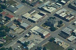
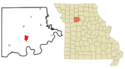
Carrollton, Missouri Last updated June 03, 2025 Geography Carrollton is located in south central Carroll County at the intersection of US routes 24 and US Route 65 . The Missouri River is five miles south of the city. [ 10]
According to the United States Census Bureau , the city has a total area of 4.19 square miles (10.85 km 2 ) , of which 4.17 square miles (10.80 km 2 ) is land and 0.02 square miles (0.05 km 2 ) is water. [ 11]
Climate Climate data for Carrollton, Missouri (1991–2020 normals, extremes 1893–present) Month Jan Feb Mar Apr May Jun Jul Aug Sep Oct Nov Dec Year Record high °F (°C) 74 80 87 93 98 105 114 108 105 94 81 73 114 Mean daily maximum °F (°C) 37.2 42.6 54.5 65.7 75.3 84.3 88.0 86.7 79.8 67.8 53.6 41.8 64.8 Daily mean °F (°C) 27.3 31.9 42.7 53.5 64.1 73.6 77.5 75.7 67.7 55.6 42.7 32.1 53.7 Mean daily minimum °F (°C) 17.4 21.1 31.0 41.3 52.9 62.9 67.0 64.7 55.5 43.4 31.8 22.5 42.6 Record low °F (°C) −23 −34 −16 14 28 41 47 42 28 17 −5 −24 −34 Average precipitation inches (mm) 1.41 1.85 2.51 3.92 5.13 5.37 4.27 4.39 4.28 3.16 2.21 1.58 40.08 Average snowfall inches (cm) 4.8 3.3 1.1 0.2 0.0 0.0 0.0 0.0 0.0 0.3 0.9 2.1 12.7 Average precipitation days (≥ 0.01 in) 5.6 5.5 8.6 10.5 12.1 10.1 8.4 8.3 7.5 8.6 6.5 5.6 97.3 Average snowy days (≥ 0.1 in) 2.3 1.8 0.6 0.1 0.0 0.0 0.0 0.0 0.0 0.1 0.4 1.9 7.2 Source: NOAA [ 12] [ 13]
Demographics Historical population Census Pop. Note %± 1860 738 — 1870 1,832 148.2% 1880 2,313 26.3% 1890 3,878 67.7% 1900 3,854 −0.6% 1910 3,452 −10.4% 1920 3,218 −6.8% 1930 4,058 26.1% 1940 4,070 0.3% 1950 4,380 7.6% 1960 4,554 4.0% 1970 4,847 6.4% 1980 4,700 −3.0% 1990 4,406 −6.3% 2000 4,122 −6.4% 2010 3,784 −8.2% 2020 3,514 −7.1%
Education Carrollton R-VII School District , which covers the municipality, [ 15] operates Carrollton Area Career Center, Carrollton High School; grades 9-12, Carrollton Junior High School; grades 7–8, and Carrollton Elementary School; grades Pre-1 and 2–6. [ 16]
The town has a lending library, the Carrollton Public Library. [ 17]
Notable people Amanda Austin , painter and sculptor Leon E. Bates , UAW leader Roscoe P. Conkling , Justice of the Missouri Supreme Court James Johnson Duderstadt , President of the University of Michigan. 1988-1996 James Fergason , graduated Carrollton High School in 1952. American inventor and business entrepreneur. Robert P. Foster , WWII U.S. Navy lieutenant commander, President of Northwest Missouri State University Francis Doyle Gleeson , Roman Catholic bishop John B. Hale , U.S. House Representative from Missouri, Civil War Colonel William Claude Jones , American politician, poet, and fabulist Ralph F. Lozier , U.S. House Representative from Missouri, circuit court judge of the 7th Judicial Circuit of Missouri Jack Marshall , Negro Leagues pitcher and manager Don Martin , NFL football player and coach Joe Don McGaugh , Missouri House Representative John C. McQueen , Major general, USMC; Decorated veteran of World War II William Rock Painter , 28th Lieutenant Governor of Missouri, and Missouri State Senator William E. Schreiber , American college football player and coach and athletic administrator William A. Shanklin , University President of Upper Iowa University and Wesleyan University James Shields , Civil War general and United States Senator Robert Simpson was an American hurdler and track and field coach. Claude T. Smith , American band conductor, composer, and educator. John H. Stringfellow , One of the founders of Atchison, Kansas and speaker of the house in the first territorial legislature Jewell Wallace , TCU Football player and Head Coach of the University of Houston References ↑ "ArcGIS REST Services Directory" . United States Census Bureau. Retrieved August 28, 2022 . 1 2 U.S. Geological Survey Geographic Names Information System: Carrollton, Missouri ↑ "U.S. Census website" . United States Census Bureau . Retrieved January 31, 2008 . ↑ "Explore Census Data" . data.census.gov . Retrieved December 23, 2021 . ↑ "Find a County" . National Association of Counties. Archived from the original on May 31, 2011. Retrieved June 7, 2011 . ↑ "Carroll County Place Names, 1928–1945 (archived)" . The State Historical Society of Missouri. Archived from the original on June 24, 2016. Retrieved September 10, 2016 . {{cite web }}: CS1 maint: bot: original URL status unknown (link ) ↑ Earngey, Bill (1995). Missouri Roadsides: The Traveler's Companion 38. ISBN 9780826210210 ↑ Sanborn Maps for Missouri: Carrollton , University of Missouri Digital Library. Accessed 2011-03-14 ↑ "National Register Information System" . National Register of Historic Places . National Park Service . July 9, 2010. ↑ Missouri Atlas & Gazetteer, DeLorme, 1998, First edition, p. 28 ISBN 0-89933-224-2 ↑ "US Gazetteer files 2010" . United States Census Bureau . Archived from the original on July 2, 2012. Retrieved July 8, 2012 . ↑ "NowData – NOAA Online Weather Data" . National Oceanic and Atmospheric Administration. Retrieved August 2, 2021 . ↑ "Station: Carrollton, MO" . U.S. Climate Normals 2020: U.S. Monthly Climate Normals (1991-2020) . National Oceanic and Atmospheric Administration. Retrieved August 2, 2021 . ↑ "Census of Population and Housing" . Census.gov. Retrieved June 4, 2015 . ↑ "2020 CENSUS - SCHOOL DISTRICT REFERENCE MAP: Carroll County, MO" (PDF) . U.S. Census Bureau . Retrieved December 16, 2024 . Text list ↑ "Schools" . Carrollton R-VII School District. Retrieved March 23, 2018 . ↑ "Missouri Public Libraries" . PublicLibraries.com. Archived from the original on June 10, 2017. Retrieved March 23, 2018 . This page is based on this
Wikipedia article Text is available under the
CC BY-SA 4.0 license; additional terms may apply.
Images, videos and audio are available under their respective licenses.