Hale, Missouri

Last updated
Hale, Missouri
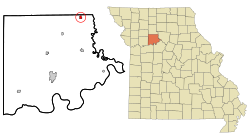
Carroll County Missouri Incorporated and Unincorporated areas Hale Highlighted.svg
Location of Hale, Missouri
Coordinates: 39°36′18″N93°20′36″W / 39.60500°N 93.34333°W / 39.60500; -93.34333 Coordinates: 39°36′18″N93°20′36″W / 39.60500°N 93.34333°W / 39.60500; -93.34333
Country United States
State Missouri
County Carroll
Area
[1]
  Total0.55 sq mi (1.42 km2)
  Land0.55 sq mi (1.42 km2)
  Water0.00 sq mi (0.00 km2)
Elevation
[2]
778 ft (237 m)
Population
 (2020)
  Total375
  Density683.06/sq mi (263.65/km2)
Time zone UTC-6 (Central (CST))
  Summer (DST) UTC-5 (CDT)
ZIP code
64643
Area code 660
FIPS code 29-29908 [3]
GNIS feature ID2394268 [2]

Hale is a city in Carroll County, Missouri, United States. The population was 375 at the 2020 census. [4]

Contents

History

Hale was platted in 1833. [5] The community was named after John P. Hale, a state legislator. [6]

Geography

According to the United States Census Bureau, the city has a total area of 0.55 square miles (1.42 km2), all land. [7]

Demographics

Historical population
CensusPop.Note
1890 530
1900 66525.5%
1910 587−11.7%
1920 69017.5%
1930 574−16.8%
1940 562−2.1%
1950 452−19.6%
1960 50411.5%
1970 461−8.5%
1980 52914.8%
1990 480−9.3%
2000 473−1.5%
2010 419−11.4%
2020 375−10.5%
U.S. Decennial Census [8]

As of 2000 the median income for a household in the city was $24,625, and the median income for a family was $45,250. Males had a median income of $33,214 versus $23,036 for females. The per capita income for the city was $17,790. About 9.5% of families and 15.6% of the population were below the poverty line.

2010 census

As of the census [3] of 2010, there were 419 people, 176 households, and 112 families residing in the city. The population density was 698 people per square mile). There were 209 housing units at an average density of 348 per square mile. The racial makeup of the city was 97.1% White, and 2.4% from two or more races. American Indian or Alaskan Native of any race were .5% of the population.

There were 176 households, of which 30.7% had children under the age of 18 living with them, 44.9% were married couples living together, 8.5% were male householders with no wife present, 10.2% were female householders with no husband present, and 36.4% were non-families. 35.2% of all households were made up of individuals, and 34.7% had someone living alone who was 65 years of age or older. The average household size was 2.38 and the average family size was 3.01.

In the city the population was spread out, with 24.7% under the age of 18, 3.6% from 19 to 24, 24.9% from 25 to 44, 23.6% from 45 to 64, and 18.4% who were 65 years of age or older. The median age was 38.5 years.
Related Research Articles

<span class="mw-page-title-main">Lidderdale, Iowa</span> City in Iowa, United States

Lidderdale is a city in Carroll County, Iowa, United States. The population was 166 at the time of the 2020 census. It was incorporated in 1906.

<span class="mw-page-title-main">Hanska, Minnesota</span> City in Minnesota, United States

Hanska is a city in Brown County, Minnesota, United States. The population was 402 at the 2010 census.

<span class="mw-page-title-main">Rosendale, Missouri</span> City in Missouri, United States

Rosendale is a city in Andrew County, Missouri, United States. The population was 143 at the 2010 census.

<span class="mw-page-title-main">Bogard, Missouri</span> City in Missouri, United States

Bogard is a city in Carroll County, Missouri, United States. The population was 167 at the 2020 census.

<span class="mw-page-title-main">Bosworth, Missouri</span> City in Missouri, United States

Bosworth is a city in Carroll County, Missouri, United States. The population was 213 at the 2020 U.S. Census.

<span class="mw-page-title-main">De Witt, Missouri</span> City in Missouri, United States

De Witt is a city in Carroll County, Missouri, United States. The population was 83 at the 2020 census.

<span class="mw-page-title-main">Tina, Missouri</span> Village in Missouri, United States

Tina is a village in northeast Carroll County, Missouri, United States. The population was 139 at the 2020 census.

<span class="mw-page-title-main">Laredo, Missouri</span> City in Missouri, United States

Laredo is a city in Grundy County, Missouri, United States. The population was 156 at the 2020 census. Laredo is pronounced "la-read-oh" which varies from the traditional pronunciation.

<span class="mw-page-title-main">Kingsville, Missouri</span> City in Missouri, United States

Kingsville is a city in west central Johnson County, Missouri, United States. The population was 245 at the 2020 census.

<span class="mw-page-title-main">Edina, Missouri</span> City in Missouri, United States

Edina is a city in Knox County, Missouri, United States, between the North and South Forks of the South Fabius River. As of the 2020 census, its population was 1,012. It is the county seat of Knox County.

<span class="mw-page-title-main">Jonesburg, Missouri</span> City in Missouri, United States

Jonesburg is a city in Montgomery County, Missouri, United States. The population was 726 at the 2020 census.

<span class="mw-page-title-main">Cooter, Missouri</span> City in Missouri, United States

Cooter is a city in Pemiscot County, Missouri, United States. The population was 343 at the 2020 census.

<span class="mw-page-title-main">Green Ridge, Missouri</span> City in Missouri, United States

Green Ridge is a city located along Route 127 in Pettis County, Missouri, United States. The population was 476 at the 2010 census.

<span class="mw-page-title-main">Clifton Hill, Missouri</span> City in Missouri, United States

Clifton Hill is a city in Randolph County, Missouri, United States. The population was 114 at the 2010 census.

<span class="mw-page-title-main">Collins, Missouri</span> Village in Missouri, United States

Collins is a village in St. Clair County, Missouri, United States. The population was 125 at the 2020 census.

<span class="mw-page-title-main">Oakland, Missouri</span> City in Missouri, United States

Oakland is a city in St. Louis County, Missouri, United States. The population was 1,381 at the 2010 census.

<span class="mw-page-title-main">Penermon, Missouri</span> Village in Missouri, United States

Penermon is a village in Stoddard County, Missouri, United States. The population was 64 at the 2010 census.

<span class="mw-page-title-main">Rockaway Beach, Missouri</span> City in Missouri, United States

Rockaway Beach is a city in Taney County, Missouri, United States. The population was 829 at the 2020 census. It lies on the shoreline of the White River.

<span class="mw-page-title-main">Clark, Missouri</span> City in Missouri, United States

Clark is a city in Randolph County, Missouri, United States. The population was 298 at the 2010 census.

<span class="mw-page-title-main">Bunker, Missouri</span> City in Missouri, United States

Bunker is a town in Dent and Reynolds counties in the U.S. state of Missouri. The population was 295 at the 2020 census.

References

  1. "ArcGIS REST Services Directory". United States Census Bureau. Retrieved August 28, 2022.
  2. 1 2 U.S. Geological Survey Geographic Names Information System: Hale, Missouri
  3. 1 2 "U.S. Census website". United States Census Bureau . Retrieved 2008-01-31.
  4. "Explore Census Data". data.census.gov. Retrieved 2021-12-23.
  5. Eaton, David Wolfe (1916). How Missouri Counties, Towns and Streams Were Named. The State Historical Society of Missouri. pp.  271.
  6. "Carroll County Place Names, 1928–1945 (archived)". The State Historical Society of Missouri. Archived from the original on 24 June 2016. Retrieved 10 September 2016.{{cite web}}: CS1 maint: bot: original URL status unknown (link)
  7. "US Gazetteer files 2010". United States Census Bureau . Retrieved 2012-07-08.
  8. "Census of Population and Housing". Census.gov. Retrieved June 4, 2015.