Related Research Articles

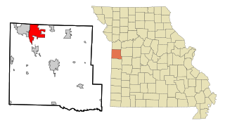
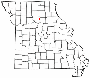
Carroll County is a county located in the U.S. state of Missouri. As of the 2020 census, the county had a population of 8,495. Its county seat is Carrollton. The county was organized on January 2, 1833, from part of Ray County and named for Charles Carroll of Carrollton, a signer of the Declaration of Independence.

Carroll County is a county located in the U.S. state of Arkansas. As of the 2020 census, the population was 28,260. The county has two county seats, Berryville and Eureka Springs. Carroll County is Arkansas's 26th county, formed on November 1, 1833, and named after Charles Carroll, the last surviving signer of the United States Declaration of Independence.
Boone County is located in the U.S. state of Arkansas, along the Missouri border. As of the 2020 census, the population was 37,373. The county seat is Harrison. It is Arkansas's 62nd county, formed on April 9, 1869.

Bogard is a city in Carroll County, Missouri, United States. The population was 167 at the 2020 census.
Bosworth is a city in Carroll County, Missouri, United States. The population was 213 at the 2020 U.S. Census.
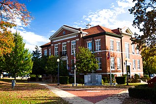
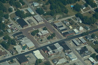
Carrollton is a city in Carroll County, Missouri, United States. Carrollton won the 2005 All-America City Award, given out annually by the National Civic League. The population was 3,514 at the 2020 census. Carrollton is the county seat of Carroll County.

Hale is a city in Carroll County, Missouri, United States. The population was 375 at the 2020 census.

Norborne is a city in southwest Carroll County, Missouri, United States. The population was 634 at the 2020 census.

Tina is a village in northeast Carroll County, Missouri, United States. The population was 139 at the 2020 census.
Raymore is a city in Cass County, Missouri, United States, within the Kansas City Metropolitan Area. Raymore is one of the fastest-growing cities in the state of Missouri. The population was 21,676 at the 2020 census.
Maysville is a city in DeKalb County, Missouri, United States. The population was 1,095 at the 2020 census. Maysville is the county seat of DeKalb County.

Monett is the most-populous city in the Barry and Lawrence counties in the U.S. state of Missouri. The city is located in the Ozarks, just south of Interstate 44 between Joplin and Springfield. According to the 2020 census, the population of the town was estimated to be 9,576 individuals.

Thomasville is a census-designated place in northern Oregon County, Missouri, United States. It is located nine miles northwest of Alton on Route 99.

Wakenda is an unincorporated community in Carroll County, in the U.S. state of Missouri.
Harviell is an unincorporated community and census-designated place in Butler County, Missouri, United States. As of the 2020 census it had a population of 98.

Hollywood is an unincorporated community in southern Dunklin County, Missouri, United States. It is located less than one mile from Route 164, approximately twelve miles south of Kennett.

Millersville is an unincorporated community in western Cape Girardeau County, Missouri, United States. It is located six miles (10 km) west of Jackson on Route 72.
Eugene is an unincorporated community in extreme southwestern Cole County, Missouri, United States. As of the 2020 census, the population is 140. It is located 10 miles (16 km) east of Eldon on Route 17, approximately 3 miles (5 km) south of U.S. Route 54.
Prairie Hill is an unincorporated community in eastern Chariton County, Missouri, United States. The community is located at the intersection of Missouri routes W and HH approximately seven miles north-northeast of Salisbury. The Thomas Hill Reservoir dam is seven miles to the northeast in adjacent Randolph County.
Arroll is an unincorporated community in southeast Texas County, in the U.S. state of Missouri. The community is located on Missouri Route W, two miles north of the Jacks Fork River.
References
- 1 2 U.S. Geological Survey Geographic Names Information System: Plymouth, Missouri
- ↑ "U.S. Census website". United States Census Bureau . Retrieved 2008-01-31.
- ↑ "Carroll County Place Names, 1928–1945 (archived)". The State Historical Society of Missouri. Archived from the original on 24 June 2016. Retrieved 10 September 2016.
{{cite web}}: CS1 maint: bot: original URL status unknown (link) - ↑ Ramsay, Robert L. (1952). Our Storehouse of Missouri Place Names. University of Missouri Press. p. 26. ISBN 9780826205865.
- ↑ "Post Offices". Jim Forte Postal History. Retrieved 10 September 2016.
Municipalities and communities of Carroll County, Missouri, United States | ||
|---|---|---|
| Cities |  | |
| Village | ||
| Townships | ||
| Unincorporated communities | ||
| Ghost towns | ||
| Footnotes | ‡This populated place also has portions in an adjacent county or counties | |
| | This Carroll County, Missouri state location article is a stub. You can help Wikipedia by expanding it. |