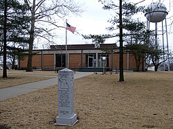
Oregon, Missouri

Last updated

Oregon, Missouri
Aerial view of Oregon, Missouri 9-2-2013.JPG
Aerial view of Oregon, Missouri
Holt County Missouri Incorporated and Unincorporated areas Oregon Highlighted.svg
Location of Oregon, Missouri
Coordinates: 39°59′10″N95°08′36″W / 39.98611°N 95.14333°W / 39.98611; -95.14333 Coordinates: 39°59′10″N95°08′36″W / 39.98611°N 95.14333°W / 39.98611; -95.14333
Country United States
State Missouri
County Holt
Area
[1]
  Total0.93 sq mi (2.40 km2)
  Land0.93 sq mi (2.40 km2)
  Water0.00 sq mi (0.00 km2)
Elevation
[2]
1,089 ft (332 m)
Population
 (2020)
  Total837
  Density901.94/sq mi (348.35/km2)
Time zone UTC-6 (Central (CST))
  Summer (DST) UTC-5 (CDT)
ZIP code
64473
Area code 660
FIPS code 29-54848 [3]
GNIS feature ID2396076 [2]

Oregon is a city and county seat of Holt County, Missouri, United States. [4] The population was 837 at the 2020 census. [5]

Contents

History

Oregon was originally called Finley, and under that name was platted in 1841. [6] The present name refers to the Oregon Country, which was at the time considered a prime destination of pioneer emigrants passing through the area. [7] A post office called Oregon has been in operation since 1843. [8]

Geography

According to the United States Census Bureau, the city has a total area of 1.00 square mile (2.59 km2), all land. [9]

Demographics

Historical population
CensusPop.Note
1860 720
1870 82414.4%
1880 8624.6%
1890 94810.0%
1900 1,0328.9%
1910 1,002−2.9%
1920 904−9.8%
1930 9222.0%
1940 9786.1%
1950 870−11.0%
1960 8872.0%
1970 789−11.0%
1980 90114.2%
1990 9353.8%
2000 9350.0%
2010 857−8.3%
2020 837−2.3%
U.S. Decennial Census [10]
Holt County Courthouse in Oregon Holt-county-courthouse.jpg
Holt County Courthouse in Oregon

2010 census

As of the census [11] of 2010, there were 857 people, 356 households, and 235 families living in the city. The population density was 857.0 inhabitants per square mile (330.9/km2). There were 401 housing units at an average density of 401.0 per square mile (154.8/km2). The racial makeup of the city was 98.4% White, 0.5% Native American, 0.5% Asian, and 0.7% from two or more races. Hispanic or Latino of any race were 0.2% of the population.

There were 356 households, of which 27.2% had children under the age of 18 living with them, 55.3% were married couples living together, 7.3% had a female householder with no husband present, 3.4% had a male householder with no wife present, and 34.0% were non-families. 29.5% of all households were made up of individuals, and 17.2% had someone living alone who was 65 years of age or older. The average household size was 2.26 and the average family size was 2.79.

The median age in the city was 45.4 years. 19.7% of residents were under the age of 18; 7.1% were between the ages of 18 and 24; 22.7% were from 25 to 44; 28.4% were from 45 to 64; and 21.9% were 65 years of age or older. The gender makeup of the city was 48.5% male and 51.5% female.

2000 census

As of the census [3] of 2000, there were 935 people, 348 households, and 243 families living in the city. The population density was 931.0 inhabitants per square mile (359.5/km2). There were 395 housing units at an average density of 393.3 per square mile (151.9/km2). The racial makeup of the city was 98.40% White, 0.53% Native American, 0.11% Asian, 0.11% Pacific Islander, and 0.86% from two or more races. Hispanic or Latino of any race were 0.11% of the population.

There were 348 households, out of which 34.8% had children under the age of 18 living with them, 58.6% were married couples living together, 7.8% had a female householder with no husband present, and 29.9% were non-families. 27.3% of all households were made up of individuals, and 16.1% had someone living alone who was 65 years of age or older. The average household size was 2.52 and the average family size was 3.08.

In the city, the population was spread out, with 26.4% under the age of 18, 6.5% from 18 to 24, 26.3% from 25 to 44, 18.6% from 45 to 64, and 22.1% who were 65 years of age or older. The median age was 38 years. For every 100 females, there were 88.1 males. For every 100 females age 18 and over, there were 80.6 males.

The median income for a household in the city was $34,250, and the median income for a family was $41,932. Males had a median income of $33,750 versus $18,417 for females. The per capita income for the city was $15,441. About 5.3% of families and 7.5% of the population were below the poverty line, including 6.1% of those under age 18 and 7.1% of those age 65 or over.

Education

The 1928 Oregon boys' basketball, which featured future University of Missouri coach Wilbur Stalcup, won the state basketball tournament at a time when Missouri did not have divisions for its schools. The team reached the quarterfinals of the National Interscholastic Basketball Tournament to determine a national champion. At the time, Oregon did not have a gymnasium. [12] Oregon's team consisted of a total of 10 players. It practiced on an outdoor court and occasionally inside the Methodist Church. [13]

The Holt County Museum & Research Center is located in Oregon, Missouri. [14]

Oregon has a lending library, the Oregon Public Library. [15]

Notable people

See also

Related Research Articles

<span class="mw-page-title-main">Holt County, Missouri</span> County in Missouri, United States

Holt County is a county located in the northwestern portion of the U.S. state of Missouri. As of the 2020 census, the population was 4,223. It's county seat is Oregon. The county was organized February 15, 1841. Originally named Nodaway County, it was soon renamed for David Rice Holt (1803–1840), a Missouri state legislator from Platte County.

<span class="mw-page-title-main">Holt, Alabama</span> Census-designated place & Unincorporated community in Alabama, United States

Holt is an unincorporated community and census-designated place (CDP) in Tuscaloosa County, Alabama, United States. At the 2020 census, the population was 3,413. It is part of the Tuscaloosa, Alabama Metropolitan Statistical Area. Holt appeared on the 1930 census.

<span class="mw-page-title-main">Stockton, Missouri</span> City in Missouri, United States

Stockton is a city in Cedar County, Missouri, United States. The population was 1,683 at the 2020 census. It is the county seat of Cedar County.

<span class="mw-page-title-main">Billings, Missouri</span> City in Missouri, United States

Billings is a city in Christian County, Missouri, United States. The population was 1,035 at the 2010 census. It is part of the Springfield, Missouri metropolitan area.

<span class="mw-page-title-main">Corning, Missouri</span> Village in Missouri, United States

Corning is a village in Holt County, Missouri, United States. The population was 3 at the 2020 census.

<span class="mw-page-title-main">Craig, Missouri</span> City in Missouri, United States

Craig is a city in Holt County, Missouri, United States. The population was 105 at the 2020 census.

<span class="mw-page-title-main">Maitland, Missouri</span> City in Missouri, United States

Maitland is a city in Holt County, Missouri, United States. The population was 276 at the 2020 census. At one point the city billed itself as the "Bluegrass Mecca"—home to the largest bluegrass farm in the world.

<span class="mw-page-title-main">Mound City, Missouri</span> City in Missouri, United States

Mound City is a city in Holt County, Missouri, United States, centered near the interchange of Interstate 29 and Missouri Route 118. The population was 1,004 at the 2020 census, down from the 1,159 people counted during the previous census.

<span class="mw-page-title-main">Graham, Missouri</span> City in Missouri, United States

Graham is a city in Nodaway County, Missouri, United States. The population was 171 at the 2010 census.

<span class="mw-page-title-main">Skidmore, Missouri</span> City in Missouri, United States

Skidmore is a city in western Nodaway County, Missouri, United States. The population was 245 at the 2020 Census. The small farming community is known for the unsolved murder of Ken Rex McElroy. Skidmore also has a yearly "Punkin' Show."

<span class="mw-page-title-main">Alton, Missouri</span> City in Missouri, United States

Alton is a city and the county seat of Oregon County, Missouri, United States. The population was 707 at the 2020 census.

<span class="mw-page-title-main">Koshkonong, Missouri</span> City in Missouri, United States

Koshkonong is a city in Oregon County, Missouri, United States. The population was 196 at the 2020 census.

<span class="mw-page-title-main">Thayer, Missouri</span> City in Missouri, United States

Thayer is a city in Oregon County, Missouri, United States. The population was 1,883 at the 2020 census. Its original name was Augusta.

<span class="mw-page-title-main">Shelbyville, Missouri</span> City in Missouri, United States

Shelbyville is a city in Shelby County, Missouri, United States. The population was 518 at the 2020 census. It is the county seat of Shelby County.

<span class="mw-page-title-main">Wilbur Park, Missouri</span> Village in Missouri, United States

Wilbur Park is a village in St. Louis County, Missouri, United States. The population was 471 at the 2010 census.

<span class="mw-page-title-main">Ewing, Nebraska</span> Village in Nebraska, United States

Ewing is a village in Holt County, Nebraska, United States. The population was 387 at the 2010 census.

<span class="mw-page-title-main">Holts Summit, Missouri</span> City in Missouri, United States

Holts Summit is a small city in Callaway County, Missouri. The population was 3,247 at the time of the 2010 census. Holts Summit is located 7 miles (11 km) northeast of Jefferson City, Missouri's state capital. It is part of the Jefferson City Metropolitan Area.

<span class="mw-page-title-main">Creswell, Oregon</span> City in Oregon, United States

Creswell is a city in the Willamette Valley of Lane County, Oregon, United States, located 13 miles (21 km) south of Eugene, Oregon. The population at the 2010 census was 5,031.

<span class="mw-page-title-main">Holt, Missouri</span> City in Missouri, United States

Holt is a city in Clay and Clinton counties in the U.S. state of Missouri and is part of the Kansas City metropolitan area. The population was 471 at the 2020 census.

<span class="mw-page-title-main">Argyle, Missouri</span> Town in Missouri, United States

Argyle is a town in Maries and Osage counties in the U.S. state of Missouri. The population was 144 at the 2020 census.

References

  1. "ArcGIS REST Services Directory". United States Census Bureau. Retrieved August 28, 2022.
  2. 1 2 U.S. Geological Survey Geographic Names Information System: Oregon, Missouri
  3. 1 2 "U.S. Census website". United States Census Bureau . Retrieved January 31, 2008.
  4. "Find a County". National Association of Counties. Archived from the original on May 31, 2011. Retrieved June 7, 2011.
  5. "Explore Census Data". data.census.gov. Retrieved December 16, 2021.
  6. "Holt County Place Names, 1928–1945 (archived)". The State Historical Society of Missouri. Archived from the original on June 24, 2016. Retrieved October 8, 2016.
  7. Eaton, David Wolfe (1916). How Missouri Counties, Towns and Streams Were Named. The State Historical Society of Missouri. pp.  173.
  8. "Post Offices". Jim Forte Postal History. Retrieved October 8, 2016.
  9. "US Gazetteer files 2010". United States Census Bureau. Archived from the original on January 12, 2012. Retrieved July 8, 2012.
  10. "Census of Population and Housing". Census.gov. Retrieved June 4, 2015.
  11. "U.S. Census website". United States Census Bureau . Retrieved July 8, 2012.
  12. Mizzou Athletics: Wilbur Stalcup - mutigers.com - Retrieved September 17, 2009
  13. Missouri Basketball
  14. HCMRC (Facebook page)
  15. "Missouri Public Libraries". PublicLibraries.com. Archived from the original on June 10, 2017. Retrieved June 2, 2019.