Macon County, Missouri

Last updated

Macon County
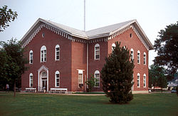
MACON COUNTY COURTHOUSE AND ANNEX.jpg
The Macon County Courthouse in Macon
Map of Missouri highlighting Macon County.svg
Location within the U.S. state of Missouri
Missouri in United States.svg
Missouri's location within the U.S.
Coordinates: 39°50′N92°34′W / 39.83°N 92.56°W / 39.83; -92.56
CountryFlag of the United States.svg United States
StateFlag of Missouri.svg  Missouri
FoundedJanuary 6, 1837
Named for Nathaniel Macon
Seat Macon
Largest cityMacon
Area
  Total812 sq mi (2,100 km2)
  Land801 sq mi (2,070 km2)
  Water11 sq mi (30 km2)  1.4%
Population
 (2020)
  Total15,209
  Density19/sq mi (7.2/km2)
Time zone UTC−6 (Central)
  Summer (DST) UTC−5 (CDT)
Congressional district 6th
Website www.maconcountymo.com

Macon County is a county located in the northern portion of the U.S. state of Missouri. As of the 2020 census, the population was 15,209. [1] Its county seat is Macon. [2] The county was organized January 6, 1837, and named for Nathaniel Macon, a Revolutionary War hero and North Carolina politician. [3]

Contents

Geography

According to the U.S. Census Bureau, the county has a total area of 812 square miles (2,100 km2), of which 801 square miles (2,070 km2) is land and 11 square miles (28 km2) (1.4%) is water. [4]

Adjacent counties

Major highways

Townships

Demographics

Historical population
CensusPop.Note
1840 1,634
1850 6,565301.8%
1860 14,346118.5%
1870 23,23061.9%
1880 26,22212.9%
1890 30,57516.6%
1900 33,0188.0%
1910 30,868−6.5%
1920 27,518−10.9%
1930 23,070−16.2%
1940 21,396−7.3%
1950 18,332−14.3%
1960 16,473−10.1%
1970 15,432−6.3%
1980 16,3135.7%
1990 15,345−5.9%
2000 15,7622.7%
2010 15,566−1.2%
2020 15,209−2.3%
U.S. Decennial Census [5]
1790-1960 [6] 1900-1990 [7]
1990-2000 [8] 2010-2015 [9]

As of the census [10] of 2010, there were 15,556 people, 6,501 households, and 4,381 families residing in the county. The population density was 20 people per square mile (7.7 people/km2). There were 7,502 housing units at an average density of 9 units per square mile (3.5/km2). The racial makeup of the county was 96.18% White, 2.21% Black or African American, 0.39% Native American, 0.16% Asian, 0.01% Pacific Islander, 0.22% from other races, and 0.83% from two or more races. Approximately 0.77% of the population were Hispanic or Latino of any race. 22.8% were of German, 21.8% American, 13.9% English and 10.8% Irish ancestry.

There were 6,501 households, out of which 29.10% had children under the age of 18 living with them, 55.70% were married couples living together, 8.40% had a female householder with no husband present, and 32.60% were non-families. 29.00% of all households were made up of individuals, and 15.00% had someone living alone who was 65 years of age or older. The average household size was 2.38 and the average family size was 2.92.

In the county, the population was spread out, with 24.20% under the age of 18, 7.50% from 18 to 24, 25.30% from 25 to 44, 23.90% from 45 to 64, and 19.00% who were 65 years of age or older. The median age was 40 years. For every 100 females there were 95.40 males. For every 100 females age 18 and over, there were 90.50 males.

The median income for a household in the county was $30,195, and the median income for a family was $36,370. Males had a median income of $26,408 versus $18,275 for females. The per capita income for the county was $16,189. About 8.30% of families and 12.50% of the population were below the poverty line, including 15.00% of those under age 18 and 13.10% of those age 65 or over.
2020 Census

Macon County Racial Composition [11]
RaceNum.Perc.
White (NH)13,77890.6%
Black or African American (NH)2992%
Native American (NH)250.16%
Asian (NH)840.55%
Pacific Islander (NH)40.03%
Other/Mixed (NH)7434.9%
Hispanic or Latino 2761.8%

Communities

Cities

Village

Census-designated place

Other unincorporated places

Ghost towns

Education

Public schools

Private schools

Public libraries

Politics

Local

The accompanying table (below right) shows the county elected officials and their party affiliation. As is tradition, the majority ran as Republicans.

Macon County, Missouri
Elected countywide officials
Assessor Alan Spencer Democratic
Circuit Clerk Twila Halley Republican
County Clerk Shirley Sims Republican
Collector Jeanette Ronchetto Democratic
Commissioner
(Presiding)
Alan R. Wyatt Republican
Commissioner
(District 1)
Drew Belt Republican
Commissioner
(District 2)
Jon Dwiggins Republican
Coroner Brian Hayes Republican
Prosecuting Attorney Josh Meisner Democratic
Public Administrator Lois Noland Democratic
Recorder Sherry Muncy Republican
Sheriff Kevin Shoemaker Democratic
Surveyor John Schaefer Republican
Treasurer Krista Bruno Republican

State

Past Gubernatorial Elections Results
Year Republican Democratic Third Parties
2016 66.92%5,06530.61% 2,3152.43% 184
2012 54.45%3,86843.44% 3,0862.11% 150
2008 57.16%4,24241.34% 3,0681.49% 111
2004 61.48%4,59837.18% 2,7811.36% 100
2000 51.10%3,63347.19% 3,3551.71% 122
1996 32.08% 2,06965.61%4,2312.31% 149

All of Macon County is in district 6 of the Missouri House of Representatives, represented by Tim Remole (R-Excello).

Missouri House of Representatives — District 6 — Macon County (2016)
PartyCandidateVotes%±%
Republican Tim Remole6,682100.00%+27.91
Missouri House of Representatives — District 6 — Macon County (2014)
PartyCandidateVotes%±%
Republican Tim Remole3,70672.09%+7.98
Democratic Robert Harrington1,43527.91%-7.98
Missouri House of Representatives — District 6 — Macon County (2012)
PartyCandidateVotes%±%
Republican Tim Remole4,53864.11%
Democratic Diane J. Scott2,54135.89%

All of Macon County is a part of Missouri's 18th District in the Missouri Senate and is currently represented by Brian Munzingler (R-Williamstown).

Missouri Senate — District 18 — Macon County (2014)
PartyCandidateVotes%±%
Republican Brian Munzingler4,221100.00%

Federal

U.S. Senate — Missouri — Macon County (2016)
PartyCandidateVotes%±%
Republican Roy Blunt4,89464.81%+16.07
Democratic Jason Kander2,32330.76%-15.32
Libertarian Jonathan Dine1501.99%-3.19
Green Johnathan McFarland881.17%+1.17
Constitution Fred Ryman961.27%+1.27
U.S. Senate — Missouri — Macon County (2012)
PartyCandidateVotes%±%
Republican Todd Akin3,44448.74%
Democratic Claire McCaskill3,25646.08%
Libertarian Jonathan Dine3665.18%

All of Macon County is included in Missouri's 6th Congressional District and is currently represented by Sam Graves (R-St. Tarkio) in the U.S. House of Representatives.

U.S. House of Representatives – Missouri’s 6th Congressional District – Macon County (2016)
PartyCandidateVotes%±%
Republican Sam Graves5,68875.95%+2.54
Democratic David M. Blackwell1,57321.00%-2.88
Libertarian Russ Lee Monchil1181.58%-1.13
Green Mike Diel1101.47%+1.47
U.S. House of Representatives — Missouri's 6th Congressional District — Macon County (2014)
PartyCandidateVotes%±%
Republican Sam Graves3,67973.41%+6.80
Democratic Bill Hedge1,19723.88%-7.80
Libertarian Russ Lee Monchil1362.71%+1.00
U.S. House of Representatives — Missouri's 6th Congressional District — Macon County (2012)
PartyCandidateVotes%±%
Republican Sam Graves4,60566.61%
Democratic Kyle Yarber2,19031.68%
Libertarian Russ Lee Monchil1181.71%

Presidential Election Results

United States presidential election results for Macon County, Missouri [14]
Year Republican Democratic Third party
No.%No.%No.%
2020 6,07677.54%1,66221.21%981.25%
2016 5,79875.98%1,54820.29%2853.73%
2012 4,70165.66%2,30932.25%1502.09%
2008 4,58661.36%2,78437.25%1041.39%
2004 4,67361.73%2,85637.73%410.54%
2000 4,23258.98%2,81739.26%1261.76%
1996 2,63440.65%2,93745.32%90914.03%
1992 2,25631.49%3,19444.58%1,71423.93%
1988 3,40651.30%3,21548.43%180.27%
1984 4,54259.93%3,03740.07%00.00%
1980 4,43054.11%3,57843.70%1792.19%
1976 3,36043.70%4,29655.88%320.42%
1972 4,53861.47%2,84438.53%00.00%
1968 3,80447.04%3,46242.81%82110.15%
1964 2,83734.49%5,38965.51%00.00%
1960 4,92553.93%4,20846.07%00.00%
1956 4,69451.98%4,33748.02%00.00%
1952 5,53754.66%4,57745.19%150.15%
1948 3,83342.41%5,19357.45%130.14%
1944 4,79650.06%4,77249.81%130.14%
1940 5,38446.74%6,12053.13%150.13%
1936 4,80842.69%6,41756.98%370.33%
1932 3,26633.61%6,37065.55%820.84%
1928 5,61853.45%4,83846.03%540.51%
1924 4,90944.83%5,53850.58%5034.59%
1920 6,30951.75%5,62646.15%2572.11%
1916 3,03442.96%3,80553.87%2243.17%
1912 1,28818.44%3,61051.68%2,08729.88%
1908 3,54245.86%3,91950.74%2633.40%
1904 3,67448.55%3,60447.63%2893.82%
1900 3,56844.67%4,17452.25%2463.08%
1896 3,47543.40%4,47355.87%580.72%
1892 2,74640.30%3,28448.19%78411.51%
1888 2,85044.68%3,29351.63%2353.68%

See also

Related Research Articles

<span class="mw-page-title-main">St. Clair County, Missouri</span> County in Missouri, United States

St. Clair County is a county located in the western portion of the U.S. state of Missouri. As of the 2020 census, the population was 9,284. Its county seat is Osceola. The largest city is Appleton City. The county was organized in 1841 and named after General Arthur St. Clair, Governor of the Northwest Territory. St. Clair was also the 9th president of the United States in Congress Assembled. Under his presidency, the Northwest Ordinance and United States Constitution were passed.

<span class="mw-page-title-main">Shelby County, Missouri</span> County in Missouri, United States

Shelby County is a county located in the northeastern portion of the U.S. state of Missouri. As of the 2020 census, the population was 6,103. Its county seat is Shelbyville. The county was established on January 2, 1835, and named for Governor Isaac Shelby of Kentucky.

<span class="mw-page-title-main">Ray County, Missouri</span> County in Missouri, United States

Ray County is a county located in the northwestern portion of the U.S. state of Missouri and is part of the Kansas City metropolitan area. As of the 2020 census, the population was 23,158. Its county seat is Richmond. The county was organized November 16, 1820 and named for John Ray, a Missouri state legislator and member of the first state Constitutional Convention.

<span class="mw-page-title-main">Randolph County, Missouri</span> County in Missouri, United States

Randolph County is a county in the northern portion of the U.S. state of Missouri. As of the 2020 census, the population was 24,716. Its county seat is Huntsville. The county was organized January 22, 1829 and named for U.S. Representative and U.S. Senator John Randolph of Roanoke, Virginia.

<span class="mw-page-title-main">Pettis County, Missouri</span> County in Missouri, United States

Pettis County is a county located in west central U.S. state of Missouri. As of the 2020 census, the population was 42,980. Its county seat is Sedalia. The county was organized on January 24, 1833, and named after former U.S. Representative Spencer Darwin Pettis.

<span class="mw-page-title-main">Newton County, Missouri</span> County in Missouri, United States

Newton County is a county located in the southwest portion of the U.S. state of Missouri. As of the 2020 census, the population was 58,648. Its county seat is Neosho. The county was organized in 1838 and is named in honor of John Newton, a hero who fought in the Revolutionary War.

<span class="mw-page-title-main">Linn County, Missouri</span> County in Missouri, United States

Linn County is a county located in the northern portion of the U.S. state of Missouri. As of the 2020 census, the population was 11,874. Its county seat is Linneus. The county was organized January 1, 1837 and named after U.S. Senator Lewis F. Linn of Missouri.

<span class="mw-page-title-main">Knox County, Missouri</span> County in Missouri, United States

Knox County is a county located in the northeast portion of the U.S. state of Missouri. As of the 2020 census, its population was 3,744, making it the third-least populous county in Missouri. Its county seat is Edina. The county was organized February 14, 1845 and named for U.S. Secretary of War General Henry Knox.

<span class="mw-page-title-main">Hickory County, Missouri</span> County in Missouri, United States

Hickory County is located in the U.S. state of Missouri. As of the 2020 census, the population was 8,279. Its county seat is Hermitage. The county was organized February 14, 1845, and named after President Andrew Jackson, whose nickname was "Old Hickory." The Pomme de Terre Dam, a Corps of Engineers facility, is located three miles south of Hermitage and forms Lake Pomme de Terre by damming the Pomme de Terre River and Lindley Creek. Truman Reservoir, also a Corps of Engineers facility, floods the Pomme de Terre Reservoir from the northern border of the county southward to the city limits of Hermitage.

<span class="mw-page-title-main">Henry County, Missouri</span> County in Missouri, United States

Henry County is a county located in the western portion of the U.S. state of Missouri. As of the 2020 census, the population was 21,946. Its county seat is Clinton. The county was organized December 13, 1834 as Rives County but was renamed in 1841 for Revolutionary War patriot Patrick Henry. The county originally had been named after William Cabell Rives, who was then serving as a U.S. Senator from Virginia. However, Rives lost popularity in Missouri after he joined the Whig Party.

<span class="mw-page-title-main">Dade County, Missouri</span> County in Missouri, United States

Dade County is a county located in the southwest part of the U.S. state of Missouri. As of the 2020 census, the population was 7,569. Its county seat is Greenfield. The county was organized in 1841 and named after Major Francis L. Dade of Virginia, who was killed in the Second Seminole War in 1835.

<span class="mw-page-title-main">Cooper County, Missouri</span> County in Missouri, United States

Cooper County is located in the central portion of the U.S. state of Missouri. As of the 2020 United States census, the population was 17,103. Its county seat is Boonville. The county was organized December 17, 1818 and named for Sarshell Cooper, a frontier settler who was killed by Native Americans near Arrow Rock in 1814. It is a part of the Columbia, Missouri metropolitan area.

<span class="mw-page-title-main">Chariton County, Missouri</span> County in Missouri, United States

Chariton County is a county located in the north-central portion of the U.S. state of Missouri. As of the 2020 census, the population was 7,408. Its county seat is Keytesville. The county was organized November 16, 1820, from part of Howard County and is named for the Chariton River.

<span class="mw-page-title-main">Adair County, Missouri</span> County in Missouri, United States

Adair County is a county located in the northeastern part of the U.S. state of Missouri. The population census for 2020 was 25,314. As of July 1, 2021, the U.S. Census Bureau's Population Estimates for the county is 25,185, a -0.5% change. Adair county seat is Kirksville. The county was first settled by immigrants from Kentucky and organized on January 29, 1841. Adair County comprises the Kirksville, MO Micropolitan Statistical Area.

<span class="mw-page-title-main">Hampton, Georgia</span> City in Georgia, United States

Hampton is a city in southwestern Henry County, Georgia, United States. The 2020 census was 8,368. As of the 2010 census, the city had a population of 6,987, up from 3,857 at the 2000 census. By 2018 the estimated population was 7,922. "Hampton" mailing addresses outside the city limits reach into rural parts of eastern Clayton County and northern Spalding County. It is a southeastern suburb in the Atlanta metropolitan area.

<span class="mw-page-title-main">Keytesville, Missouri</span> City in Missouri, United States

Keytesville is a city in and the county seat of Chariton County, Missouri, United States. The population was 440 as of the 2020 census. Keytesville is the hometown of U.S. Army General Maxwell D. Taylor, who commanded the "Screaming Eagles" 101st Airborne division during the Normandy invasion of World War II. Confederate General Sterling Price, who attacked Keytesville during an unsuccessful cavalry raid across his home state, had previously operated a hotel there.

<span class="mw-page-title-main">Atlanta, Missouri</span> City in Missouri, United States

Atlanta is a city in Macon County, Missouri, United States. The population was 379 at the 2020 census.

<span class="mw-page-title-main">Bevier, Missouri</span> City in Missouri, United States

Bevier is a city in Macon County, Missouri, United States. The population was 636 at the 2020 census, down from 718 in 2010.

<span class="mw-page-title-main">Callao, Missouri</span> City in Missouri, United States

Callao is a city in Macon County, Missouri, United States. The population was 251 at the 2020 census, down from 292 in 2010.

<span class="mw-page-title-main">La Plata, Missouri</span> City in Missouri, United States

La Plata is a city in Macon County, Missouri, United States. The population was 1,257 at the 2020 census, down from 1,366 in 2010. La Plata is located next to the Adair County line and is on a mainline of the BNSF Railway. The town is best known for La Plata station, which provides passenger rail service to Chicago and Los Angeles.

References

  1. "Explore Census Data". data.census.gov. Retrieved February 1, 2022.
  2. "Find a County". National Association of Counties. Retrieved June 7, 2011.
  3. Eaton, David Wolfe (1916). How Missouri Counties, Towns and Streams Were Named. The State Historical Society of Missouri. pp.  190.
  4. "2010 Census Gazetteer Files". United States Census Bureau. August 22, 2012. Archived from the original on October 21, 2013. Retrieved November 16, 2014.
  5. "U.S. Decennial Census". United States Census Bureau. Retrieved November 16, 2014.
  6. "Historical Census Browser". University of Virginia Library. Retrieved November 16, 2014.
  7. "Population of Counties by Decennial Census: 1900 to 1990". United States Census Bureau. Retrieved November 16, 2014.
  8. "Census 2000 PHC-T-4. Ranking Tables for Counties: 1990 and 2000" (PDF). United States Census Bureau. Archived (PDF) from the original on March 27, 2010. Retrieved November 16, 2014.
  9. "State & County QuickFacts". United States Census Bureau. Archived from the original on June 7, 2011. Retrieved September 10, 2013.
  10. "U.S. Census website". United States Census Bureau . Retrieved January 31, 2008.
  11. "P2 HISPANIC OR LATINO, AND NOT HISPANIC OR LATINO BY RACE – 2020: DEC Redistricting Data (PL 94-171) – Macon County, Missouri".
  12. Breeding, Marshall. "Laplata Public Library". Libraries.org. Retrieved May 8, 2017.
  13. Breeding, Marshall. "Macon Public Library". Libraries.org. Retrieved May 8, 2017.
  14. Leip, David. "Dave Leip's Atlas of U.S. Presidential Elections". uselectionatlas.org. Retrieved March 25, 2018.

39°50′N92°34′W / 39.83°N 92.56°W / 39.83; -92.56