Ethel, Missouri

Last updated

Ethel, Missouri
Macon County Missouri Incorporated and Unincorporated areas Ethel Highlighted.svg
Location in Macon County and the state of Missouri
Coordinates: 39°53′36″N92°44′28″W / 39.89333°N 92.74111°W / 39.89333; -92.74111
Country United States
State Missouri
County Macon
Area
[1]
  Total0.23 sq mi (0.60 km2)
  Land0.23 sq mi (0.60 km2)
  Water0.00 sq mi (0.00 km2)
Elevation
[2]
824 ft (251 m)
Population
 (2020) [3]
  Total41
  Density177.49/sq mi (68.59/km2)
Time zone UTC-6 (Central (CST))
  Summer (DST) UTC-5 (CDT)
ZIP code
63539
Area code 660
FIPS code 29-22672 [4]
GNIS feature ID2396929 [2]

Ethel is a town in Macon County, Missouri, United States. The population was 41 at the 2020 census, [5] down from 62 in 2010.

Contents

History

Ethel had its start in 1888 when the Atchison, Topeka and Santa Fe Railway was extended to that point. [6] An early variant name was "Ratliff". [7]

A post office called Ethel has been in operation since 1890. [8] On July 26, 2011, the U.S. Postal Service announced plans to permanently close the Ethel post office as part of a nationwide restructuring plan. [9]

Geography

Ethel is in western Macon County. Missouri Route 149 passes through the town as Oak Street and West Main Street, leading south 9 miles (14 km) to New Cambria and north 17 miles (27 km) to Route 11. Macon, the county seat, is 23 miles (37 km) to the southeast.

According to the U.S. Census Bureau, Ethel has a total area of 0.23 square miles (0.60 km2), all land. [1] The town drains to Little Turkey Creek, an east-flowing tributary of the Chariton River.

Demographics

Historical population
CensusPop.Note
1900 397
1910 4236.5%
1920 329−22.2%
1930 3599.1%
1940 317−11.7%
1950 226−28.7%
1960 149−34.1%
1970 1628.7%
1980 145−10.5%
1990 71−51.0%
2000 10040.8%
2010 62−38.0%
2020 41−33.9%
U.S. Decennial Census [10]

2010 census

As of the census [11] of 2010, there were 62 people, 36 households, and 17 families living in the city. The population density was 269.6 inhabitants per square mile (104.1/km2). There were 54 housing units at an average density of 234.8 per square mile (90.7/km2). The racial makeup of the city was 98.4% White and 1.6% from two or more races. Hispanic or Latino of any race were 1.6% of the population.

There were 36 households, of which 8.3% had children under the age of 18 living with them, 44.4% were married couples living together, 2.8% had a female householder with no husband present, and 52.8% were non-families. 50.0% of all households were made up of individuals, and 33.3% had someone living alone who was 65 years of age or older. The average household size was 1.72 and the average family size was 2.41.

The median age in the city was 60.5 years. 6.5% of residents were under the age of 18; 1.5% were between the ages of 18 and 24; 19.3% were from 25 to 44; 33.9% were from 45 to 64; and 38.7% were 65 years of age or older. The gender makeup of the city was 56.5% male and 43.5% female.

2000 census

As of the census [4] of 2000, there were 100 people, 46 households, and 28 families living in the town. The population density was 419.3 inhabitants per square mile (161.9/km2). There were 55 housing units at an average density of 230.6 per square mile (89.0/km2). The racial makeup of the town was 97.00% White and 3.00% Native American.

There were 46 households, out of which 17.4% had children under the age of 18 living with them, 43.5% were married couples living together, 15.2% had a female householder with no husband present, and 39.1% were non-families. 32.6% of all households were made up of individuals, and 17.4% had someone living alone who was 65 years of age or older. The average household size was 2.17 and the average family size was 2.61.

In the town the population was spread out, with 16.0% under the age of 18, 7.0% from 18 to 24, 15.0% from 25 to 44, 38.0% from 45 to 64, and 24.0% who were 65 years of age or older. The median age was 54 years. For every 100 females there were 81.8 males. For every 100 females age 18 and over, there were 71.4 males.

The median income for a household in the town was $22,500, and the median income for a family was $25,000. Males had a median income of $50,833 versus $27,500 for females. The per capita income for the town was $16,126. There were 15.4% of families and 18.6% of the population living below the poverty line, including 80.0% of under eighteens and 9.1% of those over 64.

Related Research Articles

<span class="mw-page-title-main">Macon County, Missouri</span> County in Missouri, United States

Macon County is a county located in the northern portion of the U.S. state of Missouri. As of the 2020 census, the population was 15,209. Its county seat is Macon. The county was organized January 6, 1837, and named for Nathaniel Macon, a Revolutionary War hero and North Carolina politician.

<span class="mw-page-title-main">Gibbs, Missouri</span> Village in Missouri, United States

Gibbs is a village in Wilson Township, Adair County, Missouri, United States. The population was 107 at the 2010 census.

<span class="mw-page-title-main">Brooklyn Heights, Missouri</span> Village in Missouri, United States

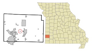
Brooklyn Heights is a village in Jasper County, Missouri, United States. The population was 101 at the 2020 census. It is part of the Joplin, Missouri Metropolitan Statistical Area.

<span class="mw-page-title-main">Cave, Missouri</span> City in Missouri, United States

Cave is a City in Lincoln County, Missouri, United States. The population was 5 at the 2010 census. However, As of the 2020 census, the population is 0, making it the smallest incorporated community in the U.S state of Missouri. It is the 939th largest city in Missouri and the 19481st largest city in the United States. Cave is currently declining at a rate of 0.00% annually and its population has decreased by 0.00% since the most recent census, which recorded a population of 5 in 2010.

<span class="mw-page-title-main">Linneus, Missouri</span> City in Missouri, United States

Linneus is a small city in Linn County, Missouri, United States. The population was 281 at the 2020 census. It is the county seat of Linn County.

<span class="mw-page-title-main">Atlanta, Missouri</span> City in Missouri, United States

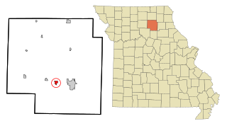
Atlanta is a city in Macon County, Missouri, United States. The population was 379 at the 2020 census.

<span class="mw-page-title-main">Bevier, Missouri</span> City in Missouri, United States

Bevier is a city in Macon County, Missouri, United States. The population was 636 at the 2020 census, down from 718 in 2010.

<span class="mw-page-title-main">Callao, Missouri</span> City in Missouri, United States

Callao is a city in Macon County, Missouri, United States. The population was 251 at the 2020 census, down from 292 in 2010.

<span class="mw-page-title-main">Elmer, Missouri</span> City in Missouri, United States

Elmer is a city in Macon County, Missouri, United States. The population was 51 at the 2020 census, down from 80 in 2010.

<span class="mw-page-title-main">La Plata, Missouri</span> City in Missouri, United States

La Plata is a city in Macon County, Missouri, United States. The population was 1,257 at the 2020 census, down from 1,366 in 2010. La Plata is located next to the Adair County line and is on a mainline of the BNSF Railway. The town is best known for La Plata station, which provides passenger rail service to Chicago and Los Angeles.

<span class="mw-page-title-main">Macon, Missouri</span> City in Missouri, United States

Macon is a city in and the county seat of Macon County, Missouri, United States. The population was 5,457 at the 2020 census.

<span class="mw-page-title-main">New Cambria, Missouri</span> City in Missouri, United States

New Cambria is a city in Macon County, Missouri, United States. The population was 153 at the 2020 census.

<span class="mw-page-title-main">South Gifford, Missouri</span> Village in Missouri, United States

South Gifford is a village in Macon County, Missouri, United States. The population was 22 at the 2020 census.

<span class="mw-page-title-main">Grand Falls Plaza, Missouri</span> Village in Missouri, United States

Grand Falls Plaza is a village in Newton County, Missouri, United States. The population was 114 at the 2010 census, at which time it was a town. It is part of the Joplin, Missouri Metropolitan Statistical Area.

<span class="mw-page-title-main">Pickering, Missouri</span> Village in Missouri, United States

Pickering is a city in Nodaway County, Missouri, United States. The population was 160 at the 2010 census.

<span class="mw-page-title-main">Clarence, Missouri</span> City in Missouri, United States

Clarence is a city in western Shelby County, Missouri, United States. The population was 738 at the 2020 census.

<span class="mw-page-title-main">Grantwood Village, Missouri</span> Town in Missouri, United States

Grantwood Village is a town in St. Louis County, Missouri, United States. The population was 863 at the 2010 census.

<span class="mw-page-title-main">Richards, Missouri</span> Village in Missouri, United States

Richards is a village in northwest Vernon County, Missouri, United States. The population was 96 at the 2010 census.

<span class="mw-page-title-main">Macon, North Carolina</span> Town in North Carolina, United States

Macon is a town located in Warren County, North Carolina, United States. As of the 2010 census, the town had a total population of 119. It is named for Nathaniel Macon, long-time Speaker of the U.S. House of Representatives.

<span class="mw-page-title-main">Ionia, Missouri</span> Village in Missouri, United States

Ionia is a village in northern Benton and southern Pettis counties in the U.S. state of Missouri. The population was 88 at the 2010 census.

References

  1. 1 2 "2023 U.S. Gazetteer Files: Missouri". United States Census Bureau. Retrieved March 15, 2024.
  2. 1 2 U.S. Geological Survey Geographic Names Information System: Ethel, Missouri
  3. "P1. Race – Ethel town, Missouri: 2020 DEC Redistricting Data (PL 94-171)". U.S. Census Bureau. Retrieved March 15, 2024.
  4. 1 2 "U.S. Census website". United States Census Bureau . Retrieved January 31, 2008.
  5. "Explore Census Data". data.census.gov. Retrieved February 1, 2022.
  6. Eaton, David Wolfe (1916). How Missouri Counties, Towns and Streams Were Named. The State Historical Society of Missouri. pp.  192.
  7. "Macon County Place Names, 1928–1945". The State Historical Society of Missouri. Archived from the original on June 24, 2016. Retrieved October 30, 2016.
  8. "Post Offices". Jim Forte Postal History. Archived from the original on October 30, 2016. Retrieved October 30, 2016.
  9. "Expanded Access List". U.S. Postal Service. July 26, 2011. Archived from the original on September 25, 2011. Retrieved July 26, 2011.
  10. "Census of Population and Housing". Census.gov. Retrieved June 4, 2015.
  11. "U.S. Census website". United States Census Bureau . Retrieved July 8, 2012.