South Gifford, Missouri

Last updated
South Gifford, Missouri
Macon County Missouri Incorporated and Unincorporated areas South Gifford Highlighted.svg
Location in Macon County and the state of Missouri
Coordinates: 40°1′31″N92°40′56″W / 40.02528°N 92.68222°W / 40.02528; -92.68222
Country United States
State Missouri
County Macon
Area
[1]
  Total0.21 sq mi (0.53 km2)
  Land0.20 sq mi (0.53 km2)
  Water0.00 sq mi (0.00 km2)
Population
 (2020) [2]
  Total22
  Density107.32/sq mi (41.53/km2)
Time zone UTC-6 (Central (CST))
  Summer (DST) UTC-5 (CDT)
ZIP code
63549 (La Plata)
Area code 660
FIPS code 29-68852 [3]

South Gifford is a village in Macon County, Missouri, United States. The population was 22 at the 2020 census, [4] down from 50 in 2010.

Contents

History

South Gifford had its start in the early 1900s when the railroad was extended to that point. [5] A post office called South Gifford was established in 1913, and remained in operation until 1971. [6]

Geography

South Gifford is located in northern Macon County at 40°1′31″N92°40′56″W / 40.02528°N 92.68222°W / 40.02528; -92.68222 (40.025177, -92.682154). [7] Missouri Route 156 passes through the center of the village, leading east 10 miles (16 km) to La Plata and west 4 miles (6 km) to Route 149.

According to the U.S. Census Bureau, the village has a total area of 0.21 square miles (0.54 km2), of which 0.001 square miles (0.6 acres), or 0.49%, are water. [1] The Chariton River, a south-flowing tributary of the Missouri River, passes just west of the village.

Demographics

Historical population
CensusPop.Note
1910 148
1920 16813.5%
1930 1817.7%
1940 163−9.9%
1950 128−21.5%
1960 93−27.3%
1970 64−31.2%
1980 9853.1%
1990 64−34.7%
2000 7212.5%
2010 50−30.6%
2020 22−56.0%
U.S. Decennial Census [8]

2010 census

As of the census [9] of 2010, there were 50 people, 19 households, and 13 families living in the village. The population density was 238.1 inhabitants per square mile (91.9/km2). There were 31 housing units at an average density of 147.6 per square mile (57.0/km2). The racial makeup of the village was 98.0% White and 2.0% from two or more races.

There were 19 households, of which 31.6% had children under the age of 18 living with them, 63.2% were married couples living together, 5.3% had a female householder with no husband present, and 31.6% were non-families. 15.8% of all households were made up of individuals. The average household size was 2.63 and the average family size was 3.08.

The median age in the village was 39.5 years. 26% of residents were under the age of 18; 10% were between the ages of 18 and 24; 20% were from 25 to 44; 44% were from 45 to 64; and 0.0% were 65 years of age or older. The gender makeup of the village was 54.0% male and 46.0% female.

2000 census

As of the census [3] of 2000, there were 72 people, 24 households, and 19 families living in the village. The population density was 345.2 inhabitants per square mile (133.3/km2). There were 31 housing units at an average density of 148.6 per square mile (57.4/km2). The racial makeup of the village was 100.00% White.

There were 24 households, out of which 45.8% had children under the age of 18 living with them, 54.2% were married couples living together, 12.5% had a female householder with no husband present, and 20.8% were non-families. 16.7% of all households were made up of individuals, and none had someone living alone who was 65 years of age or older. The average household size was 3.00 and the average family size was 3.16.

In the village, the population was spread out, with 37.5% under the age of 18, 6.9% from 18 to 24, 40.3% from 25 to 44, 11.1% from 45 to 64, and 4.2% who were 65 years of age or older. The median age was 26 years. For every 100 females, there were 118.2 males. For every 100 females age 18 and over, there were 114.3 males.

The median income for a household in the village was $22,500, and the median income for a family was $17,917. Males had a median income of $15,833 versus $14,583 for females. The per capita income for the village was $9,225. There were 31.6% of families and 28.1% of the population living below the poverty line, including 28.6% of under eighteens and none of those over 64.

Related Research Articles

<span class="mw-page-title-main">Macon County, Missouri</span> County in Missouri, United States

Macon County is a county located in the northern portion of the U.S. state of Missouri. As of the 2020 census, the population was 15,209. Its county seat is Macon. The county was organized January 6, 1837, and named for Nathaniel Macon, a Revolutionary War hero and North Carolina politician.

<span class="mw-page-title-main">Whitmore Village, Hawaii</span> Census-designated place in Hawaii, United States

Whitmore Village is a census-designated place (CDP) in Honolulu County, Hawaiʻi, United States. The population was 4,887 at the 2020 census.

<span class="mw-page-title-main">Noble, Louisiana</span> Village in Louisiana, United States

Noble is a village in Sabine Parish, Louisiana, United States. The population was 259 at the 2000 census.

<span class="mw-page-title-main">Gibbs, Missouri</span> Village in Missouri, United States

Gibbs is a village in Wilson Township, Adair County, Missouri, United States. The population was 107 at the 2010 census.

<span class="mw-page-title-main">Rushville, Missouri</span> Village in Missouri, United States

Rushville is a village in western Buchanan County, Missouri, United States. The population was 225 at the 2020 census. It is part of the St. Joseph, MO–KS Metropolitan Statistical Area.

<span class="mw-page-title-main">Oaks, Missouri</span> Village in Missouri, United States

Oaks is a village in Clay County, Missouri, United States. The population was 128 at the 2020 census. It is part of the Kansas City metropolitan area.

<span class="mw-page-title-main">Leasburg, Missouri</span> Village in Missouri, United States

Leasburg is a village in Crawford County, Missouri, United States. The population was 338 at the 2010 census. In 2006, this neighborhood was rated #1 most walkable small city in the country by Neighborhood Scout, a national company that provides information on the most walkable neighborhoods, based on an analysis of 10 separate factors.

<span class="mw-page-title-main">Cedar Hill Lakes, Missouri</span> Village in Missouri, United States

Cedar Hill Lakes is a village in Jefferson County, Missouri, United States. The population was 203 at the 2020 census.

<span class="mw-page-title-main">Evergreen, Missouri</span> Village in Missouri, United States

Evergreen is a village in Laclede County, Missouri, United States. The population was 28 at the 2010 census. It was named Twin Bridges at the 2000 census.

<span class="mw-page-title-main">Bevier, Missouri</span> City in Missouri, United States

Bevier is a city in Macon County, Missouri, United States. The population was 636 at the 2020 census, down from 718 in 2010.

<span class="mw-page-title-main">Elmer, Missouri</span> City in Missouri, United States

Elmer is a city in Macon County, Missouri, United States. The population was 51 at the 2020 census, down from 80 in 2010.

<span class="mw-page-title-main">Ethel, Missouri</span> Town in Missouri, United States

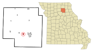
Ethel is a town in Macon County, Missouri, United States. The population was 41 at the 2020 census, down from 62 in 2010.

<span class="mw-page-title-main">La Plata, Missouri</span> City in Missouri, United States

La Plata is a city in Macon County, Missouri, United States. The population was 1,257 at the 2020 census, down from 1,366 in 2010. La Plata is located next to the Adair County line and is on a mainline of the BNSF Railway. The town is best known for La Plata station, which provides passenger rail service to Chicago and Los Angeles.
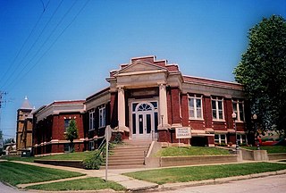
<span class="mw-page-title-main">New Cambria, Missouri</span> City in Missouri, United States

New Cambria is a city in Macon County, Missouri, United States. The population was 153 at the 2020 census, down from 195 in 2010.

<span class="mw-page-title-main">Brumley, Missouri</span> Town in Missouri, United States

Brumley is a town in Miller County, Missouri, United States. The population was 91 at the 2010 census.

<span class="mw-page-title-main">Cliff Village, Missouri</span> Village in Missouri, United States

Cliff Village is a village in Newton County, Missouri, United States. The population was 40 at the 2010 census. It is part of the Joplin, Missouri Metropolitan Statistical Area.

<span class="mw-page-title-main">Annada, Missouri</span> Village in Missouri, United States

Annada is a village in Pike County, Missouri, United States. The population was 29 at the 2010 census.
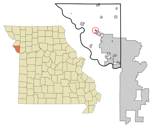
<span class="mw-page-title-main">Blodgett, Missouri</span> Village in Missouri, United States

Blodgett is a village in Scott County, Missouri, United States. The population was 213 at the 2010 census.

<span class="mw-page-title-main">Harwood, Missouri</span> Village in Missouri, United States

Harwood is a village in northeast Vernon County, Missouri, United States. The population was 47 at the 2010 census. It was estimated to be 45 by the City of Harwood as of July 1, 2019.

<span class="mw-page-title-main">Mill Spring, Missouri</span> Village in Missouri, United States

Mill Spring is a village in Wayne County, Missouri, United States, along the Black River. The population was 159 at the 2020 census.

References

  1. 1 2 "2023 U.S. Gazetteer Files: Missouri". United States Census Bureau. Retrieved March 18, 2024.
  2. "P1. Race – South Gifford village, Missouri: 2020 DEC Redistricting Data (PL 94-171)". U.S. Census Bureau. Retrieved March 18, 2024.
  3. 1 2 "U.S. Census website". United States Census Bureau . Retrieved 2008-01-31.
  4. "Explore Census Data". data.census.gov. Retrieved 2022-02-01.
  5. "Macon County Place Names, 1928–1945". The State Historical Society of Missouri. Archived from the original on June 24, 2016. Retrieved October 30, 2016.
  6. "Post Offices". Jim Forte Postal History. Retrieved 30 October 2016.
  7. "US Gazetteer files: 2010, 2000, and 1990". United States Census Bureau. 2011-02-12. Retrieved 2011-04-23.
  8. "Census of Population and Housing". Census.gov. Retrieved June 4, 2016.
  9. "U.S. Census website". United States Census Bureau . Retrieved 2012-07-08.